File:Karte Stadtteile Flensburg (da).png
Jump to navigation
Jump to search
Size of this preview: 620 × 599 pixels. Other resolutions: 248 × 240 pixels | 496 × 480 pixels | 794 × 768 pixels | 1,059 × 1,024 pixels | 1,451 × 1,403 pixels.
Original file (1,451 × 1,403 pixels, file size: 378 KB, MIME type: image/png)
Captions
Captions
Add a one-line explanation of what this file represents
Summary
[edit]| Description |
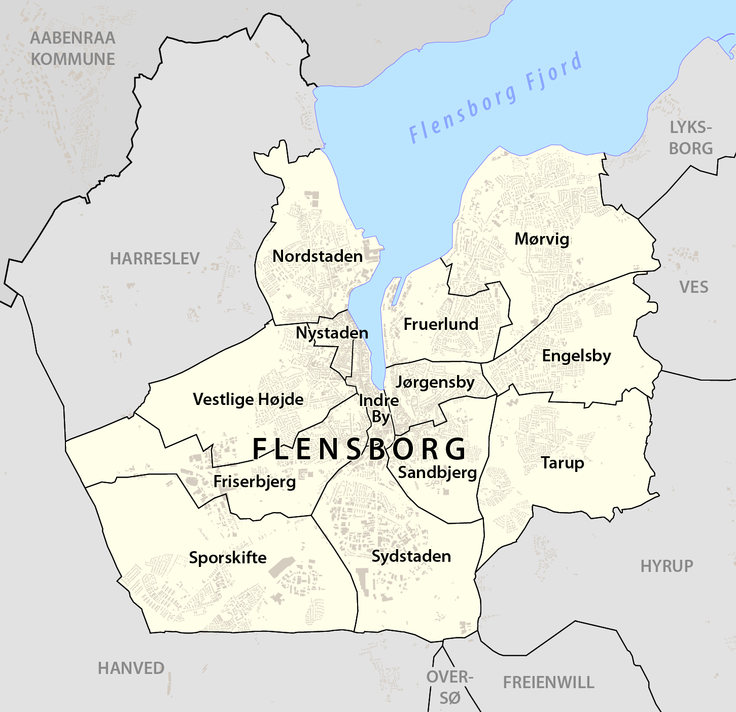
Deutsch: Karte Stadtteile Flensburg |
|||
| Date | see file history | |||
| Source |
Own work, using
|
|||
| Author | Maximilian Dörrbecker (Chumwa) | |||
| Permission (Reusing this file) |
This file is licensed under the Creative Commons Attribution-Share Alike 2.0 Generic license.
Sie dürfen das Bild zu den folgenden Bedingungen nutzen:
|
|||
| Other versions |
|


.png&action=edit§ion=1)
File history
Click on a date/time to view the file as it appeared at that time.
| Date/Time | Thumbnail | Dimensions | User | Comment | |
|---|---|---|---|---|---|
| current | 18:09, 28 February 2023 | | 1,451 × 1,403 (378 KB) | NordNordWest (talk | contribs) | upd |
| 17:11, 26 August 2016 |  | 1,451 × 1,403 (601 KB) | Chumwa (talk | contribs) | Vestlig Høj -> Vestlige Højde | |
| 20:40, 28 August 2014 |  | 1,451 × 1,403 (602 KB) | Chumwa (talk | contribs) | ||
| 20:44, 22 August 2014 |  | 1,451 × 1,403 (603 KB) | Chumwa (talk | contribs) | == {{int:filedesc}} == {{Information |Description = {{de|1=Karte Stadtteile Flensburg}} |Source={{own}}, using * OpenStreetMap data for the background * Stadt Flensburg - Fachbereich Jugend, Soziales, Gesundheit: [https://akopol.files.wordpress.... |
You cannot overwrite this file.
File usage on Commons
The following page uses this file:
File usage on other wikis
The following other wikis use this file:
- Usage on da.wikipedia.org
- Flensborg
- Frueskov
- Mørvig
- Tarup (Flensborg)
- Fruerlund (Flensborg)
- Duborg (distrikt)
- Sporskifte (Flensborg)
- Jørgensby
- Fiskergaarden
- Tved (Flensborg)
- Tvedskov
- Engelsby
- Sønderup (Flensborg)
- Adelby
- Rude (Flensborg)
- Friserbjerg
- Klus
- Osbæk (Flensborg)
- Skabelon:Flensborgs bydele
- Nystaden (Flensborg)
- Kilseng
- Adelbylund
- Nordstaden
- Indre By (Flensborg)
- Sandbjerg (Flensborg)
- Østersøbadet (Flensborg)
- Farensodde
- Exe (Flensborg)
- Harnæs (Flensborg)
- Blæsbjerg (Flensborg)
- Galvig
- Troelsby
- Skæferhus
- Fuglsang (Flensborg)
- Vandløs (Flensborg)
- Kavslund (Flensborg)
- Vejrgab
- Byparken (Flensborg)
- Hulvejene
- Vestlige Højde
- Fredshøj
- Tved Plads
- Friedheim
- Pælevad
- Sophiegård (Flensborg)
- Martinsbjerg
- Sydstaden
- Bulbjerg (Flensborg)
- Katgab
- Fruerlundgård
View more global usage of this file.
.png)
.png&oldid=737192372)