File:Karte Seebecken.png
Jump to navigation
Jump to search
Size of this preview: 800 × 460 pixels. Other resolutions: 320 × 184 pixels | 640 × 368 pixels | 1,024 × 588 pixels | 1,280 × 735 pixels | 2,000 × 1,149 pixels.
Original file (2,000 × 1,149 pixels, file size: 2.46 MB, MIME type: image/png)
Captions
Captions
Add a one-line explanation of what this file represents
Summary
[edit]
| Description |
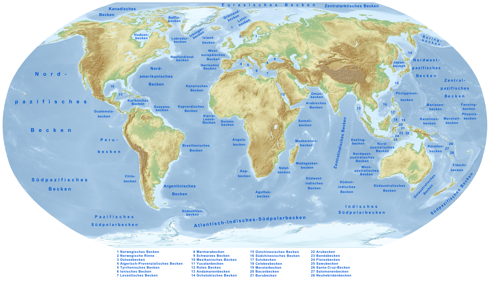
Deutsch: Karte der weltweiten Seebecken. Es ist zu beachten, dass das Ostseebecken (3) kein Seebecken im eigentlichen Sinne ist, sondern ein epikontinentales Meeresbecken.
English: Map of oceanic basins. Note that the Baltic Sea basin (3) is not an oceanic basin but an epicontinental sea basin.
Français : Carte des bassins océaniques. Notez que le bassin de Mer Baltique (3) n'est pas un bassin océanique mais un bassin de la mer épicontinentale. |
| Date | |
| Source |
own work, used:
|
| Author | Lencer |

|
This map has been made or improved in the German Kartenwerkstatt (Map Lab). You can propose maps to improve as well.
|
Licensing
[edit]
This file is licensed under the Creative Commons Attribution-Share Alike 3.0 Unported license.
- You are free:
- to share – to copy, distribute and transmit the work
- to remix – to adapt the work
- Under the following conditions:
- attribution – You must give appropriate credit, provide a link to the license, and indicate if changes were made. You may do so in any reasonable manner, but not in any way that suggests the licensor endorses you or your use.
- share alike – If you remix, transform, or build upon the material, you must distribute your contributions under the same or compatible license as the original.
File history
Click on a date/time to view the file as it appeared at that time.
| Date/Time | Thumbnail | Dimensions | User | Comment | |
|---|---|---|---|---|---|
| current | 17:58, 28 March 2009 | | 2,000 × 1,149 (2.46 MB) | Lencer (talk | contribs) | formatfix |
| 17:50, 28 March 2009 |  | 2,000 × 1,149 (2.46 MB) | Lencer (talk | contribs) | {{Information| |Description=Karte der weltweiten Seebecken |Source=own work, used: * Generic Mapping Tools and ETOPO2-data for relief, thx to NNW for rework Greenland |Date=März 2009 |Author=[[User:Lenc |
You cannot overwrite this file.
File usage on Commons
The following page uses this file:
File usage on other wikis
The following other wikis use this file:
- Usage on ca.wikipedia.org
- Usage on de.wikipedia.org
- Usage on eo.wikipedia.org
- Usage on fr.wikipedia.org
- Usage on pt.wikipedia.org
- Usage on www.wikidata.org