File:Karte Schliengen Mauchen Steinenstadt 1768.jpg
Jump to navigation
Jump to search

Size of this preview: 721 × 600 pixels. Other resolutions: 289 × 240 pixels | 577 × 480 pixels | 923 × 768 pixels | 1,231 × 1,024 pixels | 2,461 × 2,048 pixels | 5,005 × 4,165 pixels.
Original file (5,005 × 4,165 pixels, file size: 2.84 MB, MIME type: image/jpeg)
Captions
Captions
Add a one-line explanation of what this file represents
Summary
[edit]
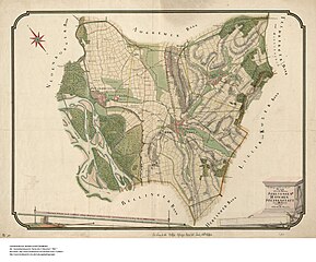
| Description | Topographischer Plan über die Baenne Schliengen Mauchen Steinenstatt disseits Rheins |
| Date | |
| Source | Landesarchiv Baden-Württemberg. Generallandesarchiv Karlsruhe. H Mauchen 1 [1] |
| Author | C. F. Erhardt, Geometer |
Licensing
[edit]
|
This work is in the public domain in its country of origin and other countries and areas where the copyright term is the author's life plus 70 years or fewer. This work is in the public domain in the United States because it was published (or registered with the U.S. Copyright Office) before January 1, 1929. | |
| This file has been identified as being free of known restrictions under copyright law, including all related and neighboring rights. | |
File history
Click on a date/time to view the file as it appeared at that time.
| Date/Time | Thumbnail | Dimensions | User | Comment | |
|---|---|---|---|---|---|
| current | 17:53, 30 November 2022 | | 5,005 × 4,165 (2.84 MB) | Zieglhar (talk | contribs) | {{Information |Description=Topographischer Plan über die Baenne Schliengen Mauchen Steinenstatt disseits Rheins |Source=Landesarchiv Baden-Württemberg. Generallandesarchiv Karlsruhe. H Mauchen 1 [http://www.landesarchiv-bw.de/plink/?f=4-1725835] |Date=1768 |Author=C. F. Erhardt, Geometer |Permission= |other_versions= }} 1768 Category:Mauchen |
You cannot overwrite this file.
File usage on Commons
There are no pages that use this file.