File:Karte Radebeul Stadtteile.png
Jump to navigation
Jump to search

Size of this preview: 800 × 581 pixels. Other resolutions: 320 × 232 pixels | 640 × 465 pixels | 1,024 × 743 pixels | 1,200 × 871 pixels.
Original file (1,200 × 871 pixels, file size: 341 KB, MIME type: image/png)
Captions
Captions
Add a one-line explanation of what this file represents
Summary
[edit]
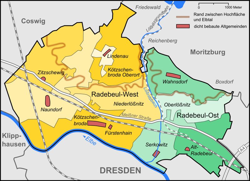
| Description | Karte der Stadtteile und Umlandgemeinden Radebeuls |
| Date | |
| Source |
"own work", used: |
| Author | Lencer |

|
This map has been made or improved in the German Kartenwerkstatt (Map Lab). You can propose maps to improve as well.
|
Licensing
[edit]
This file is licensed under the Creative Commons Attribution-Share Alike 3.0 Unported license.
- You are free:
- to share – to copy, distribute and transmit the work
- to remix – to adapt the work
- Under the following conditions:
- attribution – You must give appropriate credit, provide a link to the license, and indicate if changes were made. You may do so in any reasonable manner, but not in any way that suggests the licensor endorses you or your use.
- share alike – If you remix, transform, or build upon the material, you must distribute your contributions under the same or compatible license as the original.
File history
Click on a date/time to view the file as it appeared at that time.
| Date/Time | Thumbnail | Dimensions | User | Comment | |
|---|---|---|---|---|---|
| current | 22:48, 9 June 2015 | | 1,200 × 871 (341 KB) | Cmdrjameson (talk | contribs) | Compressed with pngout. Reduced by 115kB (25% decrease). |
| 10:47, 24 February 2008 |  | 1,200 × 871 (457 KB) | Lencer (talk | contribs) | ||
| 08:50, 19 February 2008 |  | 1,200 × 871 (457 KB) | Devilm25 (talk | contribs) | ||
| 15:47, 18 February 2008 |  | 1,200 × 871 (346 KB) | Lencer (talk | contribs) | {{Information |Description= Karte der Stadtteile und Umlandgemeinden Radebeuls |Source="own work", used: * http://home.arcor.de/mr1rbl/altgemeinden/altgem-plan.htm * http://www.openstreetmap.org |Date=Februar 2008 |Author=[[User:Len |
You cannot overwrite this file.
File usage on Commons
The following page uses this file:
File usage on other wikis
The following other wikis use this file:
- Usage on azb.wikipedia.org
- Usage on ceb.wikipedia.org
- Usage on da.wikipedia.org
- Usage on de.wikipedia.org
- Radebeul
- Elbebrücken Niederwartha
- Benutzer:Lencer
- Benutzer:Lencer/Galerie
- Benutzer:Jbergner/baustelle2
- Radebeuler Zentren
- Lößnitzgrund
- Wikipedia:Kartenwerkstatt/Archiv/2008-02
- Lößnitz (Großlage)
- Radebeuler Goldener Wagen
- Radebeuler Steinrücken
- Radebeuler Johannisberg
- Benutzer:Lencer/Unterseite
- Historische Weinberglandschaft Radebeul
- Benutzer:Jbergner/baustelle5
- Liste der denkmalgeschützten Kleinarchitekturen in Radebeul
- Liste der Radebeuler Kulturdenkmale der Lößnitzgrundbahn
- Liste der Schlösser und Herrenhäuser in Radebeul
- Liste von Winzerhäusern in Radebeul
- Liste historischer Gasthäuser in Radebeul
- Liste von historischen Schulen in Radebeul
- Liste der denkmalgeschützten Bauernhäuser in Radebeul
- Liste von denkmalgeschützten Wohnhäusern in Radebeul
- Liste der denkmalgeschützten Wohn- und Geschäftshäuser, Siedlungs- und Mietshäuser in Radebeul
- Liste von historischen Heil-, Pflege- und Sozialeinrichtungen in Radebeul
- Liste von historischen Infrastruktureinrichtungen in Radebeul
- Liste der denkmalgeschützten Industriegebäude in Radebeul
- Liste der denkmalgeschützten Denkmale und Skulpturen in Radebeul
- Liste der denkmalpflegerischen Sachgesamtheiten in Radebeul
- Liste der Werke der Landschafts- und Gartengestaltung in Radebeul
- Liste der denkmalpflegerischen Nebenanlagen in Radebeul
- Liste der Kulturdenkmale in Radebeul
- Portal:Dresden/Galerie der Besten
- Liste der Straßen und Plätze in Radebeul
- Liste von Sakralbauten in Radebeul
- Liste der Friedhöfe in Radebeul
- Portal:Straßen/Ausgezeichnete Artikel
- Liste der Stadtteile und Gemarkungen von Radebeul
- Lößnitzbach (Elbe)
- Liste der Denkmale der Kulturgeschichte in Radebeul
- Liste der Kunstdenkmäler nach Dehio 1905 in Radebeul
- Liste der Kunstdenkmäler nach Gurlitt 1904 in Radebeul
- Liste historischer Mühlen der Lößnitz
- Liste von Brunnen und Wasserspielen in Radebeul
- Meißner Straße
- Liste denkmalgeschützter Glasmalerei in Radebeul
- Liste der Technischen Denkmale in Radebeul
View more global usage of this file.