File:Karte Nahverkehr Potsdam.svg
Jump to navigation
Jump to search

Size of this PNG preview of this SVG file: 800 × 472 pixels. Other resolutions: 320 × 189 pixels | 640 × 377 pixels | 1,024 × 604 pixels | 1,280 × 755 pixels | 2,560 × 1,509 pixels | 1,294 × 763 pixels.
Original file (SVG file, nominally 1,294 × 763 pixels, file size: 762 KB)
Captions
Captions
Add a one-line explanation of what this file represents
Summary
[edit]
| Description |
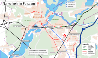
English: Map of the public transport infrastructure in Potsdam.
Deutsch: Karte der Infrastruktur des öffentlichen Personennahverkehrs in Potsdam. |
| Date | |
| Source | Own work, based on Karte Region Berlin by Maximilian Dörrbecker (Chumwa) |
| Author | Michael F. Mehnert (Nervousenergy) |
.svg)
| Camera location | | View this and other nearby images on: OpenStreetMap |
|---|
Licensing
[edit]
I, the copyright holder of this work, hereby publish it under the following licenses:

|
Permission is granted to copy, distribute and/or modify this document under the terms of the GNU Free Documentation License, Version 1.2 or any later version published by the Free Software Foundation; with no Invariant Sections, no Front-Cover Texts, and no Back-Cover Texts. A copy of the license is included in the section entitled GNU Free Documentation License. |
This file is licensed under the Creative Commons Attribution-Share Alike 3.0 Unported, 2.5 Generic, 2.0 Generic and 1.0 Generic license.
- You are free:
- to share – to copy, distribute and transmit the work
- to remix – to adapt the work
- Under the following conditions:
- attribution – You must give appropriate credit, provide a link to the license, and indicate if changes were made. You may do so in any reasonable manner, but not in any way that suggests the licensor endorses you or your use.
- share alike – If you remix, transform, or build upon the material, you must distribute your contributions under the same or compatible license as the original.
You may select the license of your choice.
File history
Click on a date/time to view the file as it appeared at that time.
| Date/Time | Thumbnail | Dimensions | User | Comment | |
|---|---|---|---|---|---|
| current | 12:17, 15 November 2015 | | 1,294 × 763 (762 KB) | Nervousenergy (talk | contribs) | Minor Fix: Converted Text to Path |
| 12:12, 15 November 2015 |  | 1,294 × 763 (785 KB) | Nervousenergy (talk | contribs) | Minor Fixes: Typo »Wannsee«, former Tram routes more visible. | |
| 10:53, 23 April 2010 |  | 1,294 × 763 (706 KB) | Michael Kümmling (talk | contribs) | small fixes | |
| 17:27, 7 April 2009 |  | 1,294 × 763 (971 KB) | Nervousenergy (talk | contribs) | Minor corrections. Added historc streetcar corridors and loops. Historische Streckenverläufe und Wendeschleifen hinzugefügt. Kleine Korrekturen. | |
| 15:04, 5 February 2009 |  | 1,294 × 763 (967 KB) | Nervousenergy (talk | contribs) | Minor improvements, neutral symbols for regional railway stations, added legend for tram/railway lines and symbols | |
| 15:28, 1 February 2009 |  | 1,294 × 763 (874 KB) | Nervousenergy (talk | contribs) | Fixed some minor Errors. (My first SVG-file) | |
| 14:33, 1 February 2009 |  | 1,353 × 996 (414 KB) | Nervousenergy (talk | contribs) | {{Information |Description={{en|1=Map of the public transport infrastructure in Potsdam.}} {{de|1=Karte der Infrastruktur des öffentlichen Personennahverkehrs in Potsdam.}} |Source=Own work, based on [[:File:Ka |
You cannot overwrite this file.
File usage on Commons
The following page uses this file:
File usage on other wikis
The following other wikis use this file:
- Usage on de.wikipedia.org