File:Karte La Palma.jpg
Jump to navigation
Jump to search
Size of this preview: 354 × 599 pixels. Other resolutions: 142 × 240 pixels | 283 × 480 pixels | 899 × 1,522 pixels.
Original file (899 × 1,522 pixels, file size: 116 KB, MIME type: image/jpeg)
Captions
Captions
Add a one-line explanation of what this file represents
Summary
[edit]| Description |
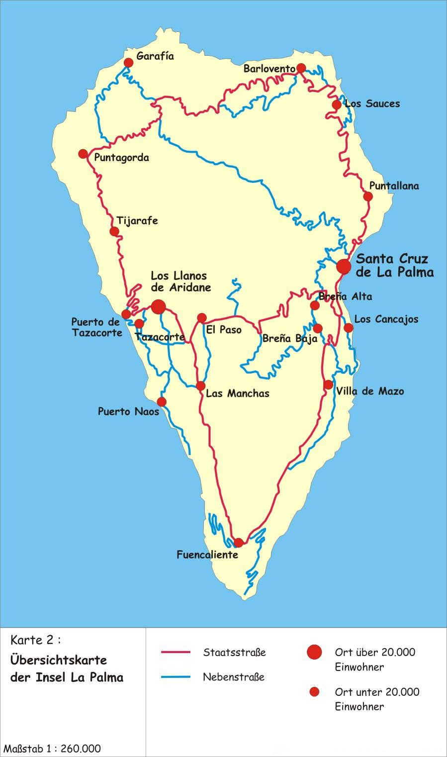
Deutsch: Eine Karte der Insel La Palma mit Fokus auf Städte sowie Staats- und Nebenstraßen im Maßstab 1:260.000 English: Map of the island of La Palma focussing on towns plus state and county roads |
| Date | |
| Source | Own work |
| Author | Robinson2007 |
| Other versions |
|


|
This map image could be re-created using vector graphics as an SVG file. This has several advantages; see Commons:Media for cleanup for more information. If an SVG form of this image is available, please upload it and afterwards replace this template with
{{vector version available|new image name}}.
It is recommended to name the SVG file “Karte La Palma.svg”—then the template Vector version available (or Vva) does not need the new image name parameter. |


Licensing
[edit]
Robinson2007 at German Wikipedia, the copyright holder of this work, hereby publishes it under the following license:
This file is licensed under the Creative Commons Attribution-Share Alike 2.0 Germany license.
Attribution: Robinson2007 at German Wikipedia
- You are free:
- to share – to copy, distribute and transmit the work
- to remix – to adapt the work
- Under the following conditions:
- attribution – You must give appropriate credit, provide a link to the license, and indicate if changes were made. You may do so in any reasonable manner, but not in any way that suggests the licensor endorses you or your use.
- share alike – If you remix, transform, or build upon the material, you must distribute your contributions under the same or compatible license as the original.

Original upload log
[edit]
Transferred from de.wikipedia to Commons.
The original description page was here. All following user names refer to de.wikipedia.
- 2007-04-09 16:55 Robinson2007 899×1522 (168776 bytes) {{Information |Beschreibung = Karte der Insel La Palma |Quelle = |Urheber = Robinson2007 |Datum = 08.04.2007 |Genehmigung = |Andere Versionen = |Anmerkungen = }}
File history
Click on a date/time to view the file as it appeared at that time.
| Date/Time | Thumbnail | Dimensions | User | Comment | |
|---|---|---|---|---|---|
| current | 21:02, 3 May 2013 | | 899 × 1,522 (116 KB) | JøMa (talk | contribs) | corrected "Breñja Alta" to "Breña Alta" |
| 20:25, 15 December 2012 |  | 899 × 1,522 (165 KB) | MGA73bot2 (talk | contribs) | {{BotMoveToCommons|de.wikipedia|year={{subst:CURRENTYEAR}}|month={{subst:CURRENTMONTHNAME}}|day={{subst:CURRENTDAY}}}} == {{int:filedesc}} == {{Information |description=Karte der Insel La Palma |date=08.04.2007 |source={{Own}}<BR />Transferred from [h... |
You cannot overwrite this file.
File usage on Commons
The following 2 pages use this file:
File usage on other wikis
The following other wikis use this file:
- Usage on ast.wikipedia.org
- Usage on de.wikipedia.org
- Usage on de.wikivoyage.org
- Usage on frr.wikipedia.org
- Usage on nl.wikipedia.org