File:Karte Insel Borkum.png
Jump to navigation
Jump to search

Size of this preview: 800 × 479 pixels. Other resolutions: 320 × 192 pixels | 640 × 383 pixels | 1,054 × 631 pixels.
Original file (1,054 × 631 pixels, file size: 338 KB, MIME type: image/png)
Captions
Captions
Add a one-line explanation of what this file represents
Summary
[edit]| Description |
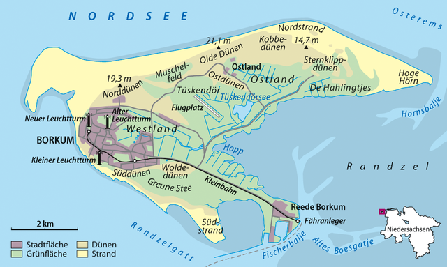
Deutsch: Karte von Borkum
English: Map of Borkum |
|
| Date | ||
| Source | Own work | |
| Author | NordNordWest | |
| Permission (Reusing this file) |
This file is licensed under the Creative Commons Attribution-Share Alike 3.0 Germany license.
 This file is licensed under the Creative Commons Attribution-Share Alike 3.0 Unported license.
|


|
This map has been made or improved in the German Kartenwerkstatt (Map Lab). You can propose maps to improve as well.
|
File history
Click on a date/time to view the file as it appeared at that time.
| Date/Time | Thumbnail | Dimensions | User | Comment | |
|---|---|---|---|---|---|
| current | 09:31, 7 February 2013 | | 1,054 × 631 (338 KB) | NordNordWest (talk | contribs) | upd |
| 21:55, 2 November 2010 |  | 1,054 × 631 (382 KB) | NordNordWest (talk | contribs) | == {{int:filedesc}} == {{Information |Description= {{de|Karte von Borkum}} {{en|Map of Borkum}} |Source={{Own}} |Date=2010-11-02 |Author={{U|NordNordWest}} |Permission={{User:NordNordWest/Licence}} {{cc-by-sa-3.0}} |other_ve |
You cannot overwrite this file.
File usage on Commons
The following 3 pages use this file:
File usage on other wikis
The following other wikis use this file:
- Usage on cs.wikipedia.org
- Usage on de.wikipedia.org
- Ostfriesische Inseln
- Borkum
- Portal:Ostfriesland
- Borkumer Kleinbahn
- Wikipedia:WikiProjekt Ostfriesland/Kartenzimmer
- Diskussion:Borkum/Archiv/1
- Wikipedia:WikiProjekt Ostfriesland/Artikel des Monats
- Wikipedia:WikiProjekt Ostfriesland/Artikel des Monats/September
- Benutzer:KaterBegemot/Kartografen
- Wikipedia:Kartenwerkstatt/Archiv/2010-11
- Wikipedia:Kartenwerkstatt/Archiv/2011-07
- Wikipedia:Kartenwerkstatt/Archiv/2011-08
- Ostlandbahn
- Ostland (Borkum)
- Marinestützpunkt Borkum
- Reede (Borkum)
- Wikipedia:Kartenwerkstatt/Karte des Tages/Galerie
- Usage on de.wiktionary.org
- Usage on en.wikipedia.org
- Usage on et.wikipedia.org
- Usage on fi.wikipedia.org
- Usage on frr.wikipedia.org
- Usage on fr.wikipedia.org
- Usage on fy.wikipedia.org
- Usage on hu.wikipedia.org
- Usage on hy.wikipedia.org
- Usage on ja.wikipedia.org
- Usage on lt.wikipedia.org
- Usage on mg.wikipedia.org
- Usage on mk.wikipedia.org
- Usage on nl.wikipedia.org
- Usage on pl.wikipedia.org
- Usage on ru.wikipedia.org
- Usage on vep.wikipedia.org
- Usage on www.wikidata.org