File:Karte Entstehung der Corps.svg
Jump to navigation
Jump to search

Size of this PNG preview of this SVG file: 566 × 599 pixels. Other resolutions: 227 × 240 pixels | 453 × 480 pixels | 726 × 768 pixels | 967 × 1,024 pixels | 1,935 × 2,048 pixels | 1,830 × 1,937 pixels.
Original file (SVG file, nominally 1,830 × 1,937 pixels, file size: 1.45 MB)
Captions
Captions
Add a one-line explanation of what this file represents
Summary
[edit]| Description |
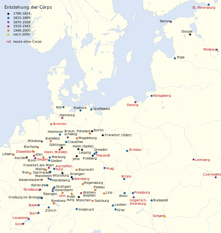
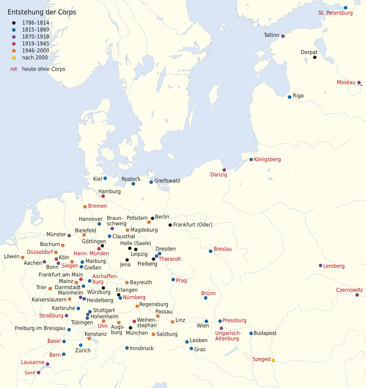
Deutsch: Karte zur Entstehung der Corps
English: Map of the foundations of German Student Corps |
|
| Date | ||
| Source | ||
| Author |
|
|
| Permission (Reusing this file) |
This file is licensed under the Creative Commons Attribution-Share Alike 3.0 Germany license.
 |
|
| Other versions | file:Karte Entstehung der Corps.png: PNG version |


|
This map has been made or improved in the German Kartenwerkstatt (Map Lab). You can propose maps to improve as well.
|
Licensing
[edit]
This file is licensed under the Creative Commons Attribution-Share Alike 3.0 Germany license.
- You are free:
- to share – to copy, distribute and transmit the work
- to remix – to adapt the work
- Under the following conditions:
- attribution – You must give appropriate credit, provide a link to the license, and indicate if changes were made. You may do so in any reasonable manner, but not in any way that suggests the licensor endorses you or your use.
- share alike – If you remix, transform, or build upon the material, you must distribute your contributions under the same or compatible license as the original.
Original upload log
[edit]
This image is a derivative work of the following images:
- File:Europe_laea_location_map.svg licensed with Cc-by-sa-3.0
- 2010-03-10T19:40:39Z Alexrk2 1401x1198 (2313185 Bytes) +San Marino, enh. coastline & countries
- 2010-03-10T18:44:00Z Alexrk2 1401x1198 (1521812 Bytes) == Summary == {{Information |Description= {{de|Positionskarte [[:de:Europa|Europa]]; Politisch mit Staatsgrenzen, Inlandgewässer; Flächentreue Azimutalprojektion}} {{en|Location map [[:en:Europe|Europe]]; Political with sta
File history
Click on a date/time to view the file as it appeared at that time.
| Date/Time | Thumbnail | Dimensions | User | Comment | |
|---|---|---|---|---|---|
| current | 18:09, 16 March 2015 | | 1,830 × 1,937 (1.45 MB) | NordNordWest (talk | contribs) | upd |
| 12:51, 18 August 2013 |  | 1,830 × 1,937 (1.43 MB) | NordNordWest (talk | contribs) | c | |
| 16:58, 30 April 2013 |  | 1,830 × 1,937 (1.45 MB) | NordNordWest (talk | contribs) | upd | |
| 09:19, 23 April 2013 |  | 1,830 × 1,937 (1.45 MB) | NordNordWest (talk | contribs) | c | |
| 17:27, 26 February 2013 |  | 1,830 × 1,937 (1.45 MB) | NordNordWest (talk | contribs) | c | |
| 12:36, 24 February 2013 |  | 1,830 × 1,937 (1.45 MB) | NordNordWest (talk | contribs) | c | |
| 11:34, 15 February 2013 |  | 1,830 × 1,937 (1.45 MB) | NordNordWest (talk | contribs) | upd | |
| 18:58, 14 February 2013 |  | 1,830 × 1,937 (1.45 MB) | NordNordWest (talk | contribs) | upd | |
| 17:14, 12 February 2013 |  | 1,830 × 1,714 (1.44 MB) | NordNordWest (talk | contribs) | == {{int:filedesc}} == {{Information |Description= {{de|Karte zur Entstehung der Corps}} {{en|Map of the foundations of German Student Corps}} |Source=*[[:File:Europe_laea_location_map.svg|Europe_laea_location... |
You cannot overwrite this file.
File usage on Commons
The following 2 pages use this file:
File usage on other wikis
The following other wikis use this file:
- Usage on cs.wikipedia.org
- Usage on de.wikipedia.org