File:Karte Eiger Umgebung.PNG
Jump to navigation
Jump to search

Size of this preview: 730 × 600 pixels. Other resolutions: 292 × 240 pixels | 584 × 480 pixels | 935 × 768 pixels | 1,247 × 1,024 pixels | 1,585 × 1,302 pixels.
Original file (1,585 × 1,302 pixels, file size: 43 KB, MIME type: image/png)
Captions
Captions
Add a one-line explanation of what this file represents
Summary
[edit]| Description |
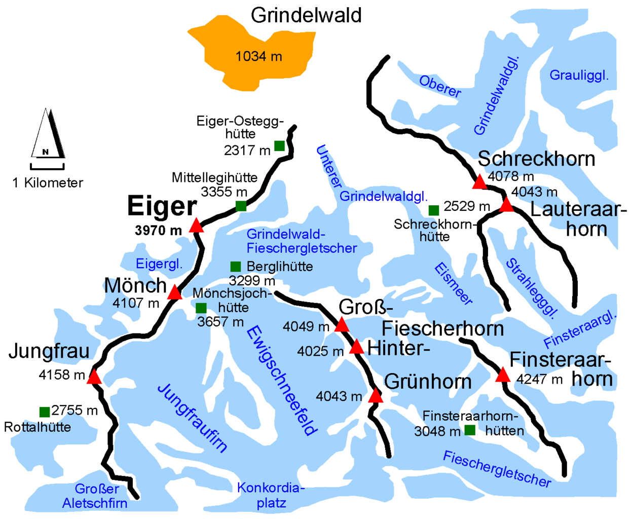
English: Map of the environment of the Eiger in Switzerland. (Red symbol=summit, green symbol=mountain hut, blue areas=glacier)
Deutsch: Vereinfachte, schematische Darstellung der Eiger-Umgebung |
| Date | |
| Source | Own work |
| Author | Kauk0r |
Erstellt nach "http://www.mapplus.ch - Landeskarte"
Licensing
[edit]I, the copyright holder of this work, hereby publish it under the following licenses:

|
Permission is granted to copy, distribute and/or modify this document under the terms of the GNU Free Documentation License, Version 1.2 or any later version published by the Free Software Foundation; with no Invariant Sections, no Front-Cover Texts, and no Back-Cover Texts. A copy of the license is included in the section entitled GNU Free Documentation License. |
This file is licensed under the Creative Commons Attribution-Share Alike 3.0 Unported license.
- You are free:
- to share – to copy, distribute and transmit the work
- to remix – to adapt the work
- Under the following conditions:
- attribution – You must give appropriate credit, provide a link to the license, and indicate if changes were made. You may do so in any reasonable manner, but not in any way that suggests the licensor endorses you or your use.
- share alike – If you remix, transform, or build upon the material, you must distribute your contributions under the same or compatible license as the original.
You may select the license of your choice.
| Annotations | This image is annotated: View the annotations at Commons |

File history
Click on a date/time to view the file as it appeared at that time.
| Date/Time | Thumbnail | Dimensions | User | Comment | |
|---|---|---|---|---|---|
| current | 20:18, 7 June 2015 | | 1,585 × 1,302 (43 KB) | Cmdrjameson (talk | contribs) | Compressed with pngout. Reduced by 93kB (68% decrease). |
| 12:06, 7 April 2009 |  | 1,585 × 1,302 (137 KB) | Kauk0r (talk | contribs) | {{Information |Description={{en|1=Map of the environment of the Eiger in Switzerland. (Red symbol=summit, green symbol=mountain hut, blue areas=glacier)}} {{de|1=Vereinfachte, schematische Darstellung der Eiger-Umgebung}} |Source=Eigenes Werk (own work) | |
You cannot overwrite this file.
File usage on Commons
There are no pages that use this file.
File usage on other wikis
The following other wikis use this file:
- Usage on cs.wikipedia.org
- Usage on en.wikipedia.org
- Usage on es.wikipedia.org
- Usage on it.wikipedia.org
- Usage on nn.wikipedia.org
- Usage on ru.wikipedia.org
- Usage on uk.wikipedia.org