File:Karte Brockenbahn.png
Jump to navigation
Jump to search
Size of this preview: 800 × 426 pixels. Other resolutions: 320 × 170 pixels | 640 × 341 pixels | 1,024 × 545 pixels | 1,280 × 682 pixels | 3,112 × 1,657 pixels.
Original file (3,112 × 1,657 pixels, file size: 6.83 MB, MIME type: image/png)
Captions
Captions
Add a one-line explanation of what this file represents
Summary
[edit]
| Description |
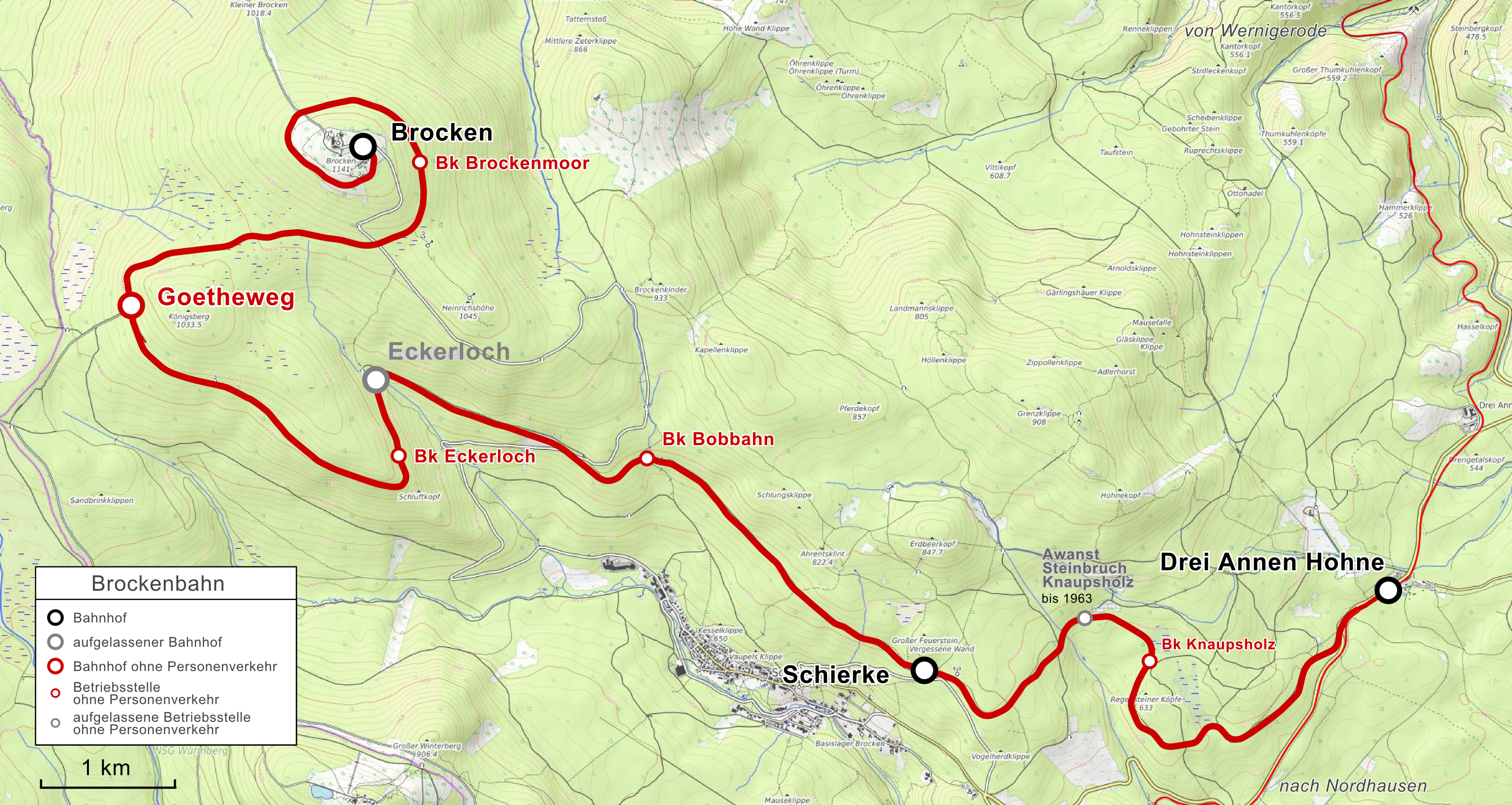
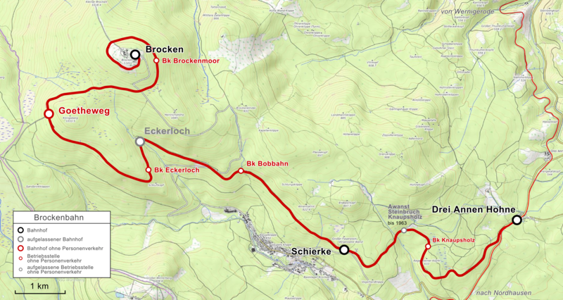
Deutsch: Karte der Brockenbahn |
|||||||||
| Date | ||||||||||
| Source |
Map was created using:
|
|||||||||
| Creator |
rendering by Pechristener |
|||||||||
| Permission (Reusing this file) |
|
|||||||||
| Geotemporal data | ||||||||||
| Bounding box |
|
|||||||||
| Georeferencing | ||||||||||
Licensing
[edit]
I, the copyright holder of this work, hereby publish it under the following license:
This file is licensed under the Creative Commons Attribution-Share Alike 3.0 Unported license.
Attribution: OpenTopoMap, Peter Christener
- You are free:
- to share – to copy, distribute and transmit the work
- to remix – to adapt the work
- Under the following conditions:
- attribution – You must give appropriate credit, provide a link to the license, and indicate if changes were made. You may do so in any reasonable manner, but not in any way that suggests the licensor endorses you or your use.
- share alike – If you remix, transform, or build upon the material, you must distribute your contributions under the same or compatible license as the original.
| This work is licensed under the Open Database License (summary). |
File history
Click on a date/time to view the file as it appeared at that time.
| Date/Time | Thumbnail | Dimensions | User | Comment | |
|---|---|---|---|---|---|
| current | 21:11, 28 August 2018 | | 3,112 × 1,657 (6.83 MB) | Pechristener (talk | contribs) | == {{int:filedesc}} == {{Information |Description ={{de|1=Karte der {{w|Brockenbahn||de}}}} |Source = Map was created using: *[http://www.openstreetmap.org/ Open Street Map] *[http://opentopomap.org/ Open Topo Map] for background |Author =rendering by {{u|Pechristener}} |Date =2018-08-28 |permission= * Map data (c) OpenStreetMap (and) contributors, CC-BY-SA * Map data background(c) OpenTopoMap, CC-BY-SA |other_versions = }} == {{int:license-header}} == {{self|c... |
You cannot overwrite this file.
File usage on Commons
The following 8 pages use this file:
- User:Chumwa/OgreBot/Potential transport maps/2018 August 21-31
- User:Chumwa/OgreBot/Public transport information/2018 August 21-31
- User:Chumwa/OgreBot/Transport Maps/2018 August 21-31
- User:Chumwa/OgreBot/Travel and communication maps/2018 August 21-31
- User:Migebert/Gallery/LKHarz/2018 August
- User:Migebert/Gallery/Wernigerode/2018 August
- User:Nordlicht8/Rail Germany/2018 August 21-31
- Category:Brockenbahn
File usage on other wikis
The following other wikis use this file:
- Usage on de.wikipedia.org
- Usage on it.wikipedia.org
- Usage on www.wikidata.org