File:Karte Bahnstrecke Neustrelitz–Warnemünde.png
Jump to navigation
Jump to search
Size of this preview: 420 × 599 pixels. Other resolutions: 168 × 240 pixels | 336 × 480 pixels | 538 × 768 pixels | 718 × 1,024 pixels | 1,501 × 2,141 pixels.
Original file (1,501 × 2,141 pixels, file size: 2.64 MB, MIME type: image/png)
Captions
Captions
Add a one-line explanation of what this file represents
Summary
[edit]
| Description |
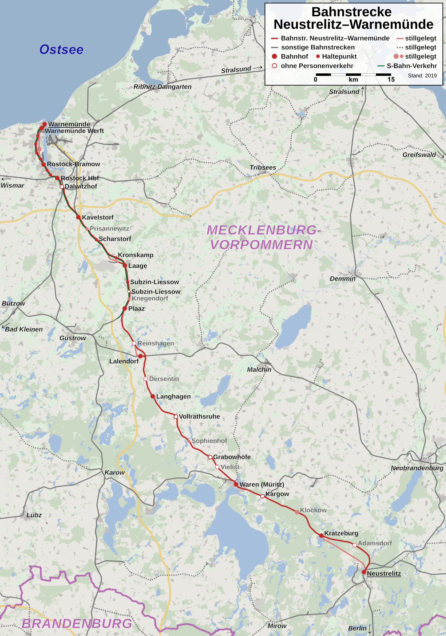
Deutsch: Karte der Bahnstrecke Neustrelitz–Warnemünde. Im Raum Rostock sind aus Gründen der Übersichtlichkeit Haltepunkte und ein stillgelegter Bahnhof nicht beschriftet. |
| Date | |
| Source | Own work, using OpenStreetMap data |
| Author | Hbf878 and OpenStreetMap contributors |
Licensing
[edit]
| Description |
This map was created from OpenStreetMap project data, collected by the community. This map may be incomplete, and may contain errors. Don't rely solely on it for navigation. |
|||
| Date | (see file history) | |||
| Source | openstreetmap.org | |||
| Creator |
OpenStreetMap contributors |
|||
| Permission (Reusing this file) |
OpenStreetMap data is available under the Open Database License (details). Map tiles are licensed under the Creative Commons Attribution-ShareAlike 2.0 license (CC-BY-SA 2.0).
This file is licensed under the Creative Commons Attribution-Share Alike 2.0 Generic license.
|
|||
| Georeferencing | If inappropriate please set warp_status = skip to hide. |
File history
Click on a date/time to view the file as it appeared at that time.
| Date/Time | Thumbnail | Dimensions | User | Comment | |
|---|---|---|---|---|---|
| current | 17:22, 9 October 2020 | | 1,501 × 2,141 (2.64 MB) | Hbf878 (talk | contribs) | Optik |
| 00:04, 1 March 2019 |  | 2,001 × 2,854 (3.63 MB) | Hbf878 (talk | contribs) | Korrekturen, Ergänzungen, freie Schriftart | |
| 10:51, 20 February 2019 |  | 2,000 × 2,854 (2.39 MB) | Hbf878 (talk | contribs) | Verbesserungen | |
| 23:11, 16 February 2019 |  | 2,000 × 2,746 (2.08 MB) | Hbf878 (talk | contribs) | User created page with UploadWizard |
You cannot overwrite this file.
File usage on Commons
The following 15 pages use this file:
- User:Chumwa/OgreBot/Potential transport maps/2019 February 10-18
- User:Chumwa/OgreBot/Potential transport maps/2019 February 19-28
- User:Chumwa/OgreBot/Potential transport maps/2019 March 1-10
- User:Chumwa/OgreBot/Public transport information/2019 February 10-18
- User:Chumwa/OgreBot/Public transport information/2019 February 19-28
- User:Chumwa/OgreBot/Public transport information/2019 March 1-10
- User:Chumwa/OgreBot/Public transport information/2020 October 1-10
- User:Chumwa/OgreBot/Transport Maps/2019 February 10-18
- User:Chumwa/OgreBot/Transport Maps/2019 February 19-28
- User:Chumwa/OgreBot/Transport Maps/2019 March 1-10
- User:Chumwa/OgreBot/Transport Maps/2020 October 1-10
- User:Chumwa/OgreBot/Travel and communication maps/2019 February 10-18
- User:Chumwa/OgreBot/Travel and communication maps/2019 February 19-28
- User:Chumwa/OgreBot/Travel and communication maps/2019 March 1-10
- File:Lloydbahn Karte.png
File usage on other wikis
The following other wikis use this file:
- Usage on de.wikipedia.org
- Usage on ko.wikipedia.org
- Usage on nl.wikipedia.org
- Usage on www.wikidata.org