File:Karte Bahn Neckarelz.png
Jump to navigation
Jump to search

Size of this preview: 759 × 600 pixels. Other resolutions: 304 × 240 pixels | 607 × 480 pixels | 972 × 768 pixels | 1,280 × 1,012 pixels | 2,480 × 1,960 pixels.
Original file (2,480 × 1,960 pixels, file size: 527 KB, MIME type: image/png)
Captions
Captions
Add a one-line explanation of what this file represents
Summary
[edit]| Description |
|
|||
| Date | ||||
| Source | conversion of Image:Karte Bahn Neckarelz.svg to PNG format | |||
| Author | K. Jähne | |||
| Other versions |
|


Licensing
[edit]
| This work has been released into the public domain by its author, kjunix. This applies worldwide. In some countries this may not be legally possible; if so: |
File history
Click on a date/time to view the file as it appeared at that time.
| Date/Time | Thumbnail | Dimensions | User | Comment | |
|---|---|---|---|---|---|
| current | 18:07, 1 June 2015 | | 2,480 × 1,960 (527 KB) | Cmdrjameson (talk | contribs) | Compressed with pngout. Reduced by 223kB (29% decrease). |
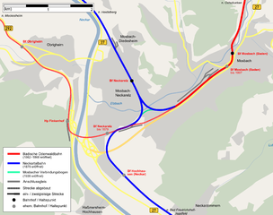
| 19:32, 19 May 2008 |  | 2,480 × 1,960 (750 KB) | Kjunix (talk | contribs) | == Description == {{Information| |Description = *{{de|Karte des Schienennetzes im Raum Mosbach mit Umgebung.}} *{{en|railway map of Mosbach and surroundings.}} |Source = conversion of Image:Karte Bahn Neckarelz.svg to PNG format |Date = 2007-08-24 |A |
You cannot overwrite this file.
File usage on Commons
The following 6 pages use this file:
File usage on other wikis
The following other wikis use this file:
- Usage on de.wikipedia.org
- Usage on en.wikipedia.org
- Usage on ja.wikipedia.org