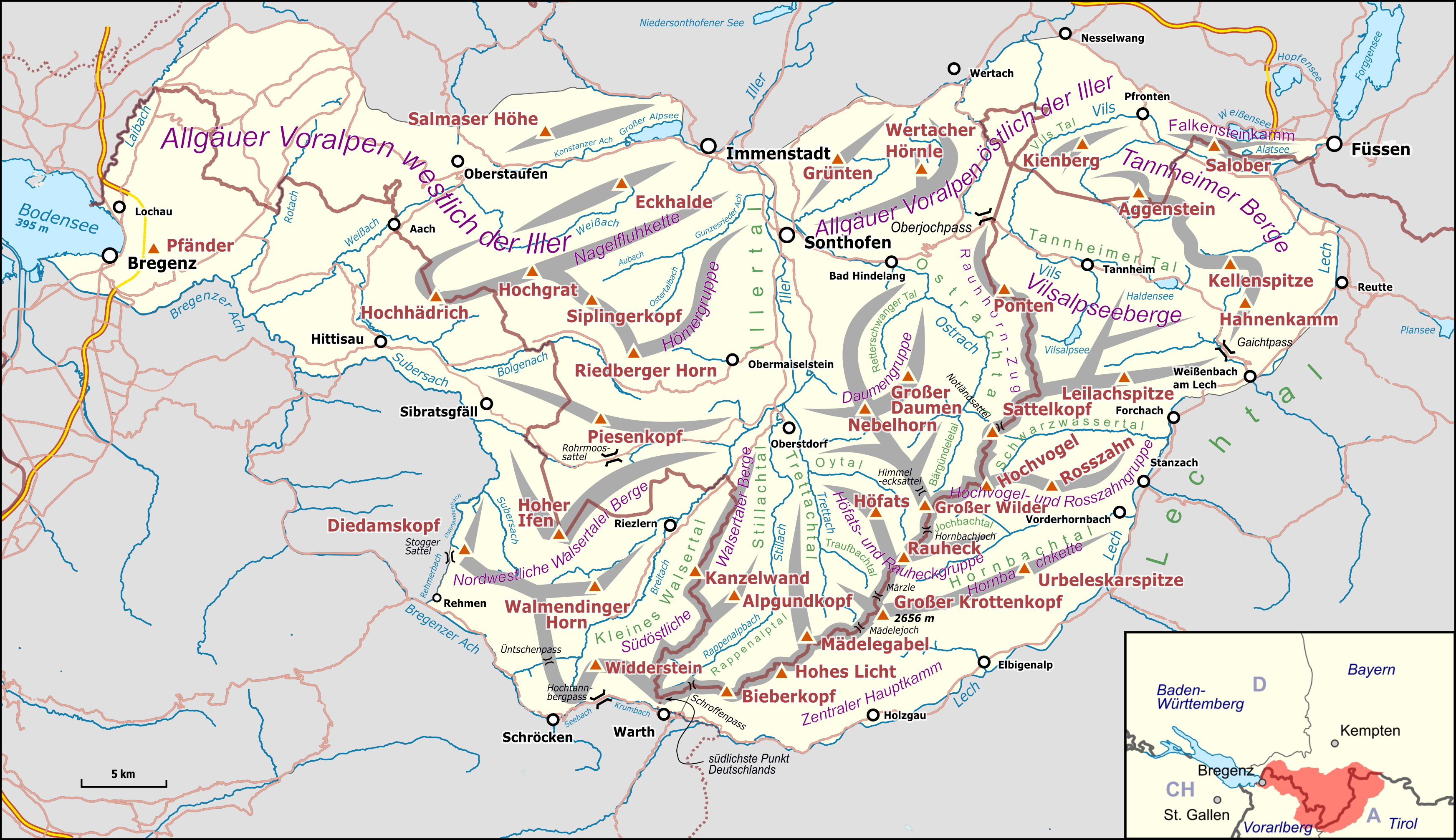
File:Karte Allgäuer Alpen.png
Jump to navigation
Jump to search
Size of this preview: 800 × 462 pixels. Other resolutions: 320 × 185 pixels | 640 × 369 pixels | 1,024 × 591 pixels | 1,280 × 739 pixels | 3,488 × 2,013 pixels.
Original file (3,488 × 2,013 pixels, file size: 2.61 MB, MIME type: image/png)
Captions
Captions
Add a one-line explanation of what this file represents
| Description |
|
|||||||||
| Date | ||||||||||
| Source |
Own work Map was created using:
|
|||||||||
| Creator |
|
|||||||||
| Permission (Reusing this file) |
Map data (c) OpenStreetMap (and) contributors, CC-BY-SA | |||||||||
| Geotemporal data | ||||||||||
| Bounding box |
|
|||||||||
| Georeferencing | ||||||||||
| This work is licensed under the Open Database License (summary). |
This file is licensed under the Creative Commons Attribution-Share Alike 3.0 Unported license.
- You are free:
- to share – to copy, distribute and transmit the work
- to remix – to adapt the work
- Under the following conditions:
- attribution – You must give appropriate credit, provide a link to the license, and indicate if changes were made. You may do so in any reasonable manner, but not in any way that suggests the licensor endorses you or your use.
- share alike – If you remix, transform, or build upon the material, you must distribute your contributions under the same or compatible license as the original.
File history
Click on a date/time to view the file as it appeared at that time.
| Date/Time | Thumbnail | Dimensions | User | Comment | |
|---|---|---|---|---|---|
| current | 19:28, 22 October 2017 | | 3,488 × 2,013 (2.61 MB) | Pechristener (talk | contribs) | Höhe Krottenkopf korr |
| 15:14, 22 October 2017 |  | 3,488 × 2,013 (2.61 MB) | Pechristener (talk | contribs) | {{Map |Description={{de|1=Übersichtskarte des {{w|Allgäuer Alpen||de}}. }} |Source ={{own}} Map was created using: *[http://www.openstreetmap.org/ Open Street Map] *{{w|Germany location map.svg}} for location map |Author = *Haupt... |
You cannot overwrite this file.
File usage on Commons
The following 6 pages use this file:
File usage on other wikis
The following other wikis use this file:
- Usage on ca.wikipedia.org
- Usage on de.wikipedia.org
- Allgäu
- Allgäuer Alpen
- Pfänder
- Waltenbergerhaus
- Hoher Ifen
- Großer Krottenkopf
- Haldenwanger Eck
- Kreuzeck (Allgäuer Alpen)
- Seealpsee (Allgäuer Alpen)
- Liste der Gebirgsgruppen in den Ostalpen (nach AVE)
- Rote Spitze (Allgäuer Alpen)
- Vorlage:Positionskarte Allgäuer Alpen
- Kienberg (Allgäuer Alpen)
- Benutzer Diskussion:Pechristener/Alpenkarten
- Alpe Gelchenwang
- Imberg (Allgäuer Alpen)
- Rickenbach (Leiblach)
- Usage on eo.wikipedia.org
- Usage on es.wikipedia.org
- Usage on fr.wikipedia.org
- Usage on it.wikipedia.org
- Usage on lv.wikipedia.org
- Usage on pl.wikivoyage.org
- Usage on sl.wikipedia.org
- Usage on uk.wikipedia.org
- Usage on www.wikidata.org