File:Karte - Schlacht bei Warburg 1760.png
Jump to navigation
Jump to search

Size of this preview: 800 × 494 pixels. Other resolutions: 320 × 197 pixels | 640 × 395 pixels | 1,024 × 632 pixels | 1,280 × 790 pixels | 3,302 × 2,037 pixels.
Original file (3,302 × 2,037 pixels, file size: 1.22 MB, MIME type: image/png)
Captions
Captions
Add a one-line explanation of what this file represents
Summary
[edit]
| Description |
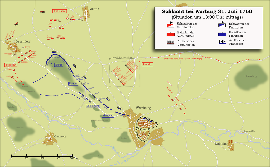
Deutsch: Karte der Schlacht bei Warburg 1760. Die Arbeit basiert auf einer Kartenbeilage aus dem Werk Großer Generalstab / Kriegsgeschichtliche Abteilung (Hrsg.): Der Siebenjährige Krieg 1756–1763, Bd.12: Landeshut und Liegnitz, Verlag Ernst Siegfried Mittler & Sohn, Berlin 1914 (= Die Kriege Friedrichs des Großen, Theil 3), die mit weiteren Angaben aus der Literatur erweitert wurde.
English: Map of the Battle of Minden 1759. The work is based on a seperate map in Großer Generalstab / Kriegsgeschichtliche Abteilung (Hrsg.): Der Siebenjährige Krieg 1756–1763, Bd.12: Landeshut und Liegnitz, Verlag Ernst Siegfried Mittler & Sohn, Berlin 1914 (= Die Kriege Friedrichs des Großen, Theil 3), which has been extended by several additional informations from literature. |
| Date | |
| Source | Own work |
| Author | Memnon335bc |
Licensing
[edit]
I, the copyright holder of this work, hereby publish it under the following license:
This file is licensed under the Creative Commons Attribution-Share Alike 3.0 Unported license.
- You are free:
- to share – to copy, distribute and transmit the work
- to remix – to adapt the work
- Under the following conditions:
- attribution – You must give appropriate credit, provide a link to the license, and indicate if changes were made. You may do so in any reasonable manner, but not in any way that suggests the licensor endorses you or your use.
- share alike – If you remix, transform, or build upon the material, you must distribute your contributions under the same or compatible license as the original.
File history
Click on a date/time to view the file as it appeared at that time.
| Date/Time | Thumbnail | Dimensions | User | Comment | |
|---|---|---|---|---|---|
| current | 22:22, 31 May 2015 | | 3,302 × 2,037 (1.22 MB) | Cmdrjameson (talk | contribs) | Compressed with pngout. Reduced by 441kB (26% decrease). |
| 13:11, 12 June 2010 |  | 3,302 × 2,037 (1.65 MB) | Memnon335bc (talk | contribs) | {{Information |Description={{de|1=Karte der Schlacht bei Warburg 1760. Die Arbeit basiert auf einer Kartenbeilage aus dem Werk Großer Generalstab / Kriegsgeschichtliche Abteilung (Hrsg.): ''Der Siebenjährige Krieg 1756–1763'', Bd.12: ''Landeshut und L |
You cannot overwrite this file.
File usage on Commons
The following 2 pages use this file:
File usage on other wikis
The following other wikis use this file:
- Usage on de.wikipedia.org
- Usage on es.wikipedia.org
- Usage on it.wikipedia.org
- Usage on ja.wikipedia.org
- Usage on nl.wikipedia.org