File:Karte3 Hochwasser Mitteleuropa 2013.png

Original file (1,856 × 1,631 pixels, file size: 1.3 MB, MIME type: image/png)
Captions
Captions
Summary
[edit]| DescriptionKarte3 Hochwasser Mitteleuropa 2013.png |
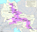
Deutsch: Übersichtskarte zum Hochwasser in Mitteleuropa von 2013
- betroffene Abschnitte der größten Flüsse - Landkreise (D), Kraje (CZ), Länder (A), Megyei (H) mit Katastrophenalarm |
| Date | (UTC) |
| Source |
This file was derived from: Karte Hochwasser in Mitteleuropa 2013.png: |
| Author |
|
| This is a retouched picture, which means that it has been digitally altered from its original version. Modifications: Elbe above Poděbrady unmarked, in Germany Kreise marked instead of Länder. The original can be viewed here: Karte Hochwasser in Mitteleuropa 2013.png:
|
Licensing
[edit]- You are free:
- to share – to copy, distribute and transmit the work
- to remix – to adapt the work
- Under the following conditions:
- attribution – You must give appropriate credit, provide a link to the license, and indicate if changes were made. You may do so in any reasonable manner, but not in any way that suggests the licensor endorses you or your use.
- share alike – If you remix, transform, or build upon the material, you must distribute your contributions under the same or compatible license as the original.
Original upload log
[edit]This image is a derivative work of the following images:
- File:Karte_Hochwasser_in_Mitteleuropa_2013.png licensed with Cc-by-sa-3.0
- 2013-06-25T21:16:58Z Alexrk2 1856x1631 (2162755 Bytes) added Salzach
- 2013-06-21T18:42:02Z Alexrk2 1856x1631 (2159364 Bytes) rev.
- 2013-06-20T16:20:37Z Alexrk2 1856x1631 (2128222 Bytes) == Summary == {{Information |Description= {{de|Übersichtskarte zum Hochwasser in Mitteleuropa von 2013}} {{en|Overview map of the 2013 European floods}} |Source=own work |Date=2013-06 |Author=[[:de:Benutzer:Alexrk2|Alexrk2]]
Uploaded with derivativeFX
File history
Click on a date/time to view the file as it appeared at that time.
| Date/Time | Thumbnail | Dimensions | User | Comment | |
|---|---|---|---|---|---|
| current | 13:47, 18 August 2013 |  | 1,856 × 1,631 (1.3 MB) | Ulamm (talk | contribs) | minor colour mendings |
| 13:16, 18 August 2013 |  | 1,856 × 1,631 (1.31 MB) | Ulamm (talk | contribs) | Inn marked already from Breitenbach (Tyrol) after web research "Inn Tirol Hochwasser 2013. And in Bavaria large parts of Rosenheim were flooded due to a broken dam. In CZ also Berounka river cause major problems, see cs.wiki. Also Weiße Elster penetra... | |
| 12:00, 18 August 2013 |  | 1,856 × 1,631 (1.33 MB) | Ulamm (talk | contribs) | kleine Schönheitsfehler ausgebessert | |
| 09:48, 18 August 2013 |  | 1,856 × 1,631 (1.4 MB) | Ulamm (talk | contribs) | == {{int:filedesc}} == {{Information |Description={{de|Übersichtskarte zum Hochwasser in Mitteleuropa von 2013}} - betroffene Abschnitte der größten Flüsse - Landkreise (D), Kraje (CZ), Länder (A), Megyei (H) mit Katastrophenalarm |Source={{Deriv... |
You cannot overwrite this file.
File usage on Commons
There are no pages that use this file.
File usage on other wikis
The following other wikis use this file:
- Usage on de.wikipedia.org
Metadata
This file contains additional information such as Exif metadata which may have been added by the digital camera, scanner, or software program used to create or digitize it. If the file has been modified from its original state, some details such as the timestamp may not fully reflect those of the original file. The timestamp is only as accurate as the clock in the camera, and it may be completely wrong.
| Horizontal resolution | 31.1 dpc |
|---|---|
| Vertical resolution | 31.1 dpc |
| Software used |