File:Karta Si︠e︡vernago Ledovitago okeana v granit︠s︡akh Rossīĭskoĭ Imperīi - sostavlena na osnovanīi russkikh gidrograficheskikh izsli︠e︡dovanīĭ s 1734 po 1871 god LOC 92685396.jpg
Jump to navigation
Jump to search

Size of this preview: 800 × 432 pixels. Other resolutions: 320 × 173 pixels | 640 × 345 pixels | 1,024 × 553 pixels | 1,280 × 691 pixels | 2,560 × 1,382 pixels | 16,265 × 8,780 pixels.
Original file (16,265 × 8,780 pixels, file size: 24.24 MB, MIME type: image/jpeg)
Captions
Captions
Add a one-line explanation of what this file represents
Summary
[edit]| Warning | The original file is very high-resolution. It might not load properly or could cause your browser to freeze when opened at full size. |
|---|
| Description |
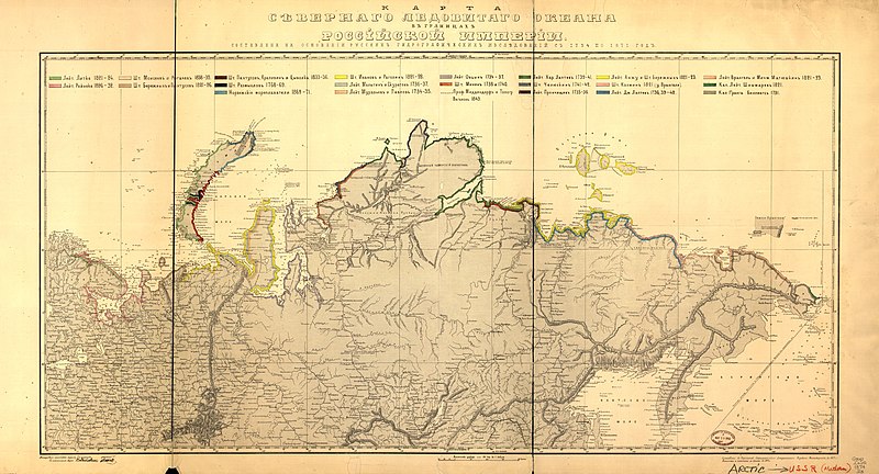
English: Hand col. in watercolors to show northern Russian coastline with explorers'/surveyers' names and dates of survey for each section. "Popolnena i pechatana s kamni︠a︡ v 1874 g." Available also through the Library of Congress Web site as a raster image. ARP 2 copies, copy 1 torn, fold-lined, and annotated in margin. |
||
| Title | Karta Si︠e︡vernago Ledovitago okeana v granit︠s︡akh Rossīĭskoĭ Imperīi : sostavlena na osnovanīi russkikh gidrograficheskikh izsli︠e︡dovanīĭ s 1734 po 1871 god | ||
| Shelf ID | G7062.C6S12 1874 .R8 MLC | ||
| Date | |||
| Source | https://www.loc.gov/item/92685396/ | ||
| Author | Russia. Gidrograficheskīĭ Departament. Chertezhnai︠A | ||
| Permission (Reusing this file) |
|
||
| Location | Arctic Ocean · Russia | ||
| Part of | American Memory · General Maps · Catalog · Geography And Map Division | ||
| Subject | Maps · Arctic Ocean · Coasts · Russia · Discovery And Exploration |

Licensing
[edit]
|
This is a faithful photographic reproduction of a two-dimensional, public domain work of art. The work of art itself is in the public domain for the following reason:
The official position taken by the Wikimedia Foundation is that "faithful reproductions of two-dimensional public domain works of art are public domain".
This photographic reproduction is therefore also considered to be in the public domain in the United States. In other jurisdictions, re-use of this content may be restricted; see Reuse of PD-Art photographs for details. | ||||
File history
Click on a date/time to view the file as it appeared at that time.
| Date/Time | Thumbnail | Dimensions | User | Comment | |
|---|---|---|---|---|---|
| current | 13:32, 15 May 2018 | | 16,265 × 8,780 (24.24 MB) | Fæ (talk | contribs) | LOC Maps https://www.loc.gov/item/92685396/ #8951 |
You cannot overwrite this file.
File usage on Commons
There are no pages that use this file.
File usage on other wikis
The following other wikis use this file: