File:Karnataka-districts-2007-numbered.png
Jump to navigation
Jump to search

Size of this preview: 379 × 600 pixels. Other resolutions: 152 × 240 pixels | 550 × 870 pixels.
Original file (550 × 870 pixels, file size: 20 KB, MIME type: image/png)
Captions
Captions
Add a one-line explanation of what this file represents

|
This locator map image could be re-created using vector graphics as an SVG file. This has several advantages; see Commons:Media for cleanup for more information. If an SVG form of this image is available, please upload it and afterwards replace this template with
{{vector version available|new image name}}.
It is recommended to name the SVG file “Karnataka-districts-2007-numbered.svg”—then the template Vector version available (or Vva) does not need the new image name parameter. |
| Description |
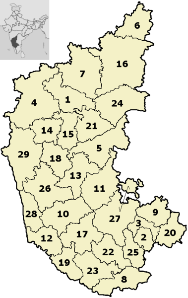
English: Districts of Karnataka, numbered (as of 2007)
|
||||||||
| Date | |||||||||
| Source | Based on File:Karnataka-districts-blank.png and File:IndiaKarnataka.png | ||||||||
| Author | Original files: Nichalp; derivative work: BishkekRocks | ||||||||
| Permission (Reusing this file) |
|

File history
Click on a date/time to view the file as it appeared at that time.
| Date/Time | Thumbnail | Dimensions | User | Comment | |
|---|---|---|---|---|---|
| current | 11:14, 18 September 2009 | | 550 × 870 (20 KB) | BishkekRocks (talk | contribs) | {{Information |Description={{en|1=Districts of Karnataka, numbered (as of 2007) # Bagalkot # Bangalore Urban # Bangalore Rural # Belgaum # Bellary # Bidar # Bijapur # Chamarajanagar # Chikballapur # Chikmagalur # Chitradurga # Dakshina Kannada # Davanage |
You cannot overwrite this file.
File usage on Commons
There are no pages that use this file.