File:Karikal 1931.jpg
Jump to navigation
Jump to search

Size of this preview: 525 × 599 pixels. Other resolutions: 210 × 240 pixels | 421 × 480 pixels | 781 × 891 pixels.
Original file (781 × 891 pixels, file size: 565 KB, MIME type: image/jpeg)
Captions
Captions
Add a one-line explanation of what this file represents
Summary
[edit]
| Description |
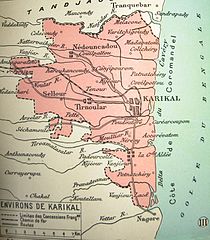
Français : Territoire de Karikal à quelque 80 km au sud de Pondichéry, côte du Coromandel. Deuxième en importance des cinq "comptoirs de l'Inde". Aujourd'hui, Karikal est un des quatre districts du Union Territory of Puducherry. Carte contenue dans L'Atlas colonial français, 1931. English: Territory of Karikal some 80 km south of Pondicherry on the Coromandel coast. Karikal, the second in importance of the five territories of French India, is now one of the four districts of the Union Territory of Puducherry. published in the Atlas colonial français, 1931. |
| Date | |
| Source | Atlas colonial français. Colonies, protectorats et pays sous mandat. |
| Author | L'Illustration, 1931 |
Licensing
[edit]
|
This work is in the public domain in its country of origin and other countries and areas where the copyright term is the author's life plus 70 years or fewer. | |
| This file has been identified as being free of known restrictions under copyright law, including all related and neighboring rights. | |
File history
Click on a date/time to view the file as it appeared at that time.
| Date/Time | Thumbnail | Dimensions | User | Comment | |
|---|---|---|---|---|---|
| current | 12:34, 12 October 2015 | | 781 × 891 (565 KB) | Lubiesque (talk | contribs) | Contrast enhanced. |
| 01:08, 6 March 2014 |  | 781 × 891 (272 KB) | Lubiesque (talk | contribs) | User created page with UploadWizard |
You cannot overwrite this file.
File usage on Commons
There are no pages that use this file.
File usage on other wikis
The following other wikis use this file:
- Usage on de.wikipedia.org
- Usage on fr.wikipedia.org
- Usage on te.wikipedia.org