File:Karakorams.jpg
Jump to navigation
Jump to search

Size of this preview: 752 × 600 pixels. Other resolutions: 301 × 240 pixels | 602 × 480 pixels | 963 × 768 pixels | 1,280 × 1,021 pixels | 2,048 × 1,633 pixels.
Original file (2,048 × 1,633 pixels, file size: 528 KB, MIME type: image/jpeg)
Captions
Captions
Add a one-line explanation of what this file represents
Summary
[edit]| Description |
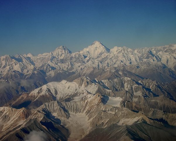
English: Karakorams from a great vantage point. Kanjut Sar (right) and Yukshin Gardan Sar (behind Yutmaru Sar) of the Hispar Muztagh, a subrange of the Karakorams, in the background. The mountains in the foreground belong to the eastern part of the Rakaposhi-Haramosh mountains. They are separated from the Spantik-Sosbun mountains in the middle by the Basha Valley (and Chogolungma glacier on the far left). |
| Date | |
| Source | Own work |
| Author | Sohaibshamim |
| Other versions |
.jpg)
Licensing
[edit]
I, the copyright holder of this work, hereby publish it under the following license:
This file is licensed under the Creative Commons Attribution-Share Alike 3.0 Unported license.
- You are free:
- to share – to copy, distribute and transmit the work
- to remix – to adapt the work
- Under the following conditions:
- attribution – You must give appropriate credit, provide a link to the license, and indicate if changes were made. You may do so in any reasonable manner, but not in any way that suggests the licensor endorses you or your use.
- share alike – If you remix, transform, or build upon the material, you must distribute your contributions under the same or compatible license as the original.
This image was uploaded as part of Wiki Loves Earth 2015.
|
 |
| Annotations | This image is annotated: View the annotations at Commons |
File history
Click on a date/time to view the file as it appeared at that time.
| Date/Time | Thumbnail | Dimensions | User | Comment | |
|---|---|---|---|---|---|
| current | 08:36, 31 May 2015 | | 2,048 × 1,633 (528 KB) | Sohaibshamim (talk | contribs) | User created page with UploadWizard |
You cannot overwrite this file.
File usage on Commons
The following page uses this file:
File usage on other wikis
The following other wikis use this file:
- Usage on hi.wikipedia.org