File:Kapliczka przydrożna pośrodku głównego skrzyżowania w dolinnej części Wilkówca w 2016 r. Widok ku S. 02.jpg
Jump to navigation
Jump to search

Size of this preview: 800 × 600 pixels. Other resolutions: 320 × 240 pixels | 640 × 480 pixels | 1,024 × 768 pixels | 1,280 × 960 pixels | 2,560 × 1,920 pixels | 3,264 × 2,448 pixels.
Original file (3,264 × 2,448 pixels, file size: 4.12 MB, MIME type: image/jpeg)
Captions
Captions
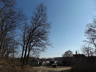
Wayside shrine in the middle of the main intersection in the lower part of Wilkówiec in 2016. View towards S
Summary
[edit]
| Description |
Polski: Kapliczka przydrożna w formie metalowego krzyż z metalową figurką, przedstawiającą Ukrzyżowanego Jezusa Chrystusa. Krzyż osadzony na kamiennym postumencie. Kapliczka okolona drewnianym płotem, umieszczona pośrodku głównego skrzyżowania w dolinnej części Wilkówca w 2016 r. Droga na zachód, po prawej stronie krzyża, wiedzie do Czerwińska nad Wisłą. Droga na wschód, po lewej stronie krzyża, wiedzie do Miączyna. Droga na północ, za krzyżem, wiedzie do Chociszewa. Widok ku S. Obszar specjalnej ochrony siedlisk Kampinoska Dolina Wisły.
English: Wayside shrine in the form of a metal cross with a metal figure depicting the Crucified Jesus Christ. The cross is set on a stone pedestal. A wayside shrine surrounded by a wooden fence, placed in the center of the main intersection in the lower part of Wilkówiec in 2016.
The road to the west, on the right side of the cross, leads to Czerwińsk nad Wisłą. The road to the east, on the left side of the cross, leads to Miączyn. The road to the north, following the cross, leads to Chociszewo. View towards S. |
|||
| Date | ||||
| Source |
Photo - own work; objects -
|
|||
| Author | VVerka5 |
| Camera location | | View this and other nearby images on: OpenStreetMap |
|---|
Licensing
[edit]
This file is licensed under the Creative Commons Attribution-Share Alike 4.0 International license.
- You are free:
- to share – to copy, distribute and transmit the work
- to remix – to adapt the work
- Under the following conditions:
- attribution – You must give appropriate credit, provide a link to the license, and indicate if changes were made. You may do so in any reasonable manner, but not in any way that suggests the licensor endorses you or your use.
- share alike – If you remix, transform, or build upon the material, you must distribute your contributions under the same or compatible license as the original.
File history
Click on a date/time to view the file as it appeared at that time.
| Date/Time | Thumbnail | Dimensions | User | Comment | |
|---|---|---|---|---|---|
| current | 21:41, 8 June 2021 | | 3,264 × 2,448 (4.12 MB) | VVerka5 (talk | contribs) | Uploaded a work by VVerka5 from Photo - own work; objects - {{FoP-Poland}} with UploadWizard |
You cannot overwrite this file.
File usage on Commons
There are no pages that use this file.