File:Kantor Bupati Pidie Jaya, Meureudu.jpg
Original file (2,517 × 1,416 pixels, file size: 1.91 MB, MIME type: image/jpeg)
Captions
Summary
[edit]DescriptionKantor Bupati Pidie Jaya, Meureudu.jpg |
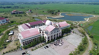
English: Regent office of Pidie Jaya in Meureudu, Aceh, Indonesia |
Date | |
Source | https://bappeda.pidiejayakab.go.id/ |
Author | Government of Pidie Jaya, Aceh |
Camera location | 5° 13′ 44.32″ N, 96° 14′ 44.08″ E | View this and other nearby images on: OpenStreetMap | 5.228979; 96.245578 |
---|
Licensing
[edit]Public domainPublic domainfalsefalse |
This file is in the public domain in Indonesia, because it is published and distributed by the Government of Republic of Indonesia, according to Article 43 of Law 28 of 2014 on copyrights.
Any of the following acts are not considered Copyright infringement:
العربية ∙ Basa Bali ∙ English ∙ Bahasa Indonesia ∙ 日本語 ∙ Jawa ∙ Minangkabau ∙ Bahaso Melayu Jambi ∙ македонски ∙ Bahasa Melayu ∙ português ∙ русский ∙ Sunda ∙ 简体中文 ∙ 繁體中文 ∙ +/− |
File history
Click on a date/time to view the file as it appeared at that time.
Date/Time | Thumbnail | Dimensions | User | Comment | |
---|---|---|---|---|---|
current | 15:15, 16 January 2024 | 2,517 × 1,416 (1.91 MB) | Afif Brika1 (talk | contribs) | Uploaded a work by Government of Pidie Jaya, Aceh from https://bappeda.pidiejayakab.go.id/ with UploadWizard |
You cannot overwrite this file.
File usage on Commons
There are no pages that use this file.
File usage on other wikis
The following other wikis use this file:
- Usage on en.wikipedia.org
- Usage on id.wikipedia.org
Metadata
This file contains additional information such as Exif metadata which may have been added by the digital camera, scanner, or software program used to create or digitize it. If the file has been modified from its original state, some details such as the timestamp may not fully reflect those of the original file. The timestamp is only as accurate as the clock in the camera, and it may be completely wrong.
Image title |
|
---|---|
Camera manufacturer | DJI |
Camera model | FC6510 |
Exposure time | 1/500 sec (0.002) |
F-number | f/6.3 |
ISO speed rating | 100 |
Date and time of data generation | 11:20, 14 February 2018 |
Lens focal length | 8.8 mm |
Latitude | 5° 13′ 44.32″ N |
Longitude | 96° 14′ 44.08″ E |
Altitude | 38.92 meters above sea level |
Short title |
|
Orientation | Normal |
Software used | v01.06.1582 |
File change date and time | 11:20, 14 February 2018 |
Y and C positioning | Centered |
Exposure Program | Normal program |
Exif version | 2.3 |
Date and time of digitizing | 11:20, 14 February 2018 |
Meaning of each component |
|
Image compression mode | 3.5429472126276 |
APEX aperture | 5.31 |
APEX exposure bias | 0 |
Maximum land aperture | 2.97 APEX (f/2.8) |
Subject distance | 0 meters |
Metering mode | Center weighted average |
Light source | Unknown |
Flash | Flash did not fire, No flash function |
DateTimeOriginal subseconds | 00 |
DateTimeDigitized subseconds | 00 |
Supported Flashpix version | 0.1 |
Color space | sRGB |
File source | Digital still camera |
Scene type | A directly photographed image |
Custom image processing | Normal process |
Exposure mode | Auto exposure |
White balance | Auto white balance |
Focal length in 35 mm film | 24 mm |
Scene capture type | Standard |
Scene control | None |
Contrast | Normal |
Saturation | Normal |
Sharpness | Normal |
Subject distance range | Unknown |
GPS tag version | 2.3.0.0 |
Keywords |
|