File:Kantatie 40 Turku region.svg
Jump to navigation
Jump to search

Size of this PNG preview of this SVG file: 800 × 567 pixels. Other resolutions: 320 × 227 pixels | 640 × 453 pixels | 1,024 × 725 pixels | 1,280 × 907 pixels | 2,560 × 1,813 pixels | 840 × 595 pixels.
Original file (SVG file, nominally 840 × 595 pixels, file size: 440 KB)
Captions
Captions
Add a one-line explanation of what this file represents
Summary
[edit]
| Description |
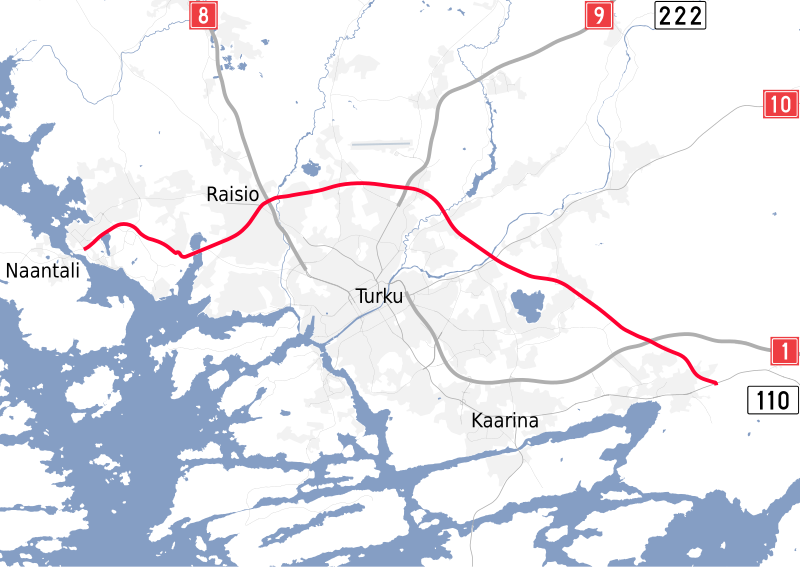
English: A map of the Turku Ring Road/Finnish National Road 40 in the vicinity of Turku, and its connecting main roads.
Suomi: Kartta Kantatie 40/Turun Kehätiestä Turun läheisyydessä ja sen yhdistävät pääväylät. |
| Date | |
| Source |
Own work
|
| Author | Nelg |
Licensing
[edit]
I, the copyright holder of this work, hereby publish it under the following licenses:
This file is licensed under the Creative Commons Attribution-Share Alike 4.0 International license.
- You are free:
- to share – to copy, distribute and transmit the work
- to remix – to adapt the work
- Under the following conditions:
- attribution – You must give appropriate credit, provide a link to the license, and indicate if changes were made. You may do so in any reasonable manner, but not in any way that suggests the licensor endorses you or your use.
- share alike – If you remix, transform, or build upon the material, you must distribute your contributions under the same or compatible license as the original.

|
Permission is granted to copy, distribute and/or modify this document under the terms of the GNU Free Documentation License, Version 1.2 or any later version published by the Free Software Foundation; with no Invariant Sections, no Front-Cover Texts, and no Back-Cover Texts. A copy of the license is included in the section entitled GNU Free Documentation License. |
You may select the license of your choice.
File history
Click on a date/time to view the file as it appeared at that time.
| Date/Time | Thumbnail | Dimensions | User | Comment | |
|---|---|---|---|---|---|
| current | 23:46, 27 December 2017 | | 840 × 595 (440 KB) | Nelg (talk | contribs) | Uploading unoptimized SVG |
| 23:40, 27 December 2017 |  | 840 × 595 (267 KB) | Nelg (talk | contribs) | Re-upload | |
| 23:06, 27 December 2017 |  | 840 × 595 (246 KB) | Nelg (talk | contribs) | {{Information |Description ={{en|1=A map of the Turku Ring Road/Finnish National Road 40 in the vicinity of Turku, and its connecting main roads.}} {{fi|1=Kartta Kantatie 40/Turun Kehätiestä Turun lähei... |
You cannot overwrite this file.
File usage on Commons
The following 5 pages use this file:
- User:Apalsola/recent uploads/Roads in Finland/2017 December 21-31
- User:Chumwa/OgreBot/Potential transport maps/2017 December 21-31
- User:Chumwa/OgreBot/Transport Maps/2017 December 21-31
- User:Chumwa/OgreBot/Travel and communication maps/2017 December 21-31
- User:Makele-90/recent uploads/Finland Proper/2017 December
File usage on other wikis
The following other wikis use this file:
- Usage on fi.wikipedia.org