File:Kanjut Sar (3to4).jpg
Jump to navigation
Jump to search

Size of this preview: 800 × 600 pixels. Other resolutions: 320 × 240 pixels | 640 × 480 pixels | 990 × 742 pixels.
Original file (990 × 742 pixels, file size: 227 KB, MIME type: image/jpeg)
Captions
Captions
Add a one-line explanation of what this file represents
| Description |
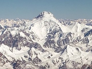
English: Aerial view of the Karakorams: Yukshin Gardan Sar (left) and Kanjut Sar (centre)
Deutsch: Luftaufnahme des Karakorums: Yukshin Gardan Sar (links) und Kanjut Sar (mitte) |
||
| Date | |||
| Source | originally posted to Flickr as Peak | ||
| Author | *_* | ||
| Permission (Reusing this file) |
This file is licensed under the Creative Commons Attribution-Share Alike 2.0 Generic license.
|
||
| Other versions | Derivative works of this file: |

| Annotations | This image is annotated: View the annotations at Commons |
.jpg)
File history
Click on a date/time to view the file as it appeared at that time.
| Date/Time | Thumbnail | Dimensions | User | Comment | |
|---|---|---|---|---|---|
| current | 06:50, 29 April 2022 | | 990 × 742 (227 KB) | PenangLion (talk | contribs) | File:Kanjut Sar.jpg cropped 54 % horizontally, 74 % vertically using CropTool with precise mode. |
You cannot overwrite this file.
File usage on Commons
The following page uses this file:
.jpg&oldid=652853038)