File:Kammuri 2019-12-02 0435Z.jpg

Original file (6,556 × 6,941 pixels, file size: 6.82 MB, MIME type: image/jpeg)
Captions
Captions
Summary
[edit]| DescriptionKammuri 2019-12-02 0435Z.jpg |
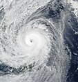
English: On December 2, 2019, a typhoon brought violent winds and torrential rainfall to the central Philippines, causing thousands of people to evacuate low-lying and mudslide-prone areas. The storm known as Kammuri (or Tisoy in the Philippines) is expected to pass Manila, the country’s capital, on December 3.
The image above shows Kammuri approaching landfall on December 2, when the typhoon’s maximum wind speed reached 90 knots (105 miles/170 kilometers per hour). The image was acquired by the Visible Infrared Imaging Radiometer Suite (VIIRS) on the NOAA-NASA Suomi NPP satellite. Kammuri rapidly intensified from a category 1 to category 4 storm in 24 hours from December 1-2 before making landfall at Gubat. At the time of landfall on December 2, peak winds were estimated to be in category 3 range. By December 4, the storm is expected to weaken and exit into the South China Sea. The Philippines meteorological agency, PAGASA, warned of possible flooding and landslides in several coastal areas over the next few days. More than six inches (15 centimeters) of rainfall are expected across the region through December 4, particularly affecting the Bicol Region, Calabarzon, Mimaropa, and Central Luzon, which includes Manila. PAGASA forecasted a storm surge up to three meters (10 feet) for many coastal areas. Winds could also knock over many trees and blow off the roofs of houses. |
| Date | |
| Source | https://earthobservatory.nasa.gov/images/145945/typhoon-kammuri-approaches-the-philippines |
| Author | NASA Earth Observatory image by Joshua Stevens, using VIIRS data from NASA EOSDIS/LANCE and GIBS/Worldview, and the Suomi National Polar-orbiting Partnership. Story by Kasha Patel. |
Licensing
[edit]| Public domainPublic domainfalsefalse |
| This file is in the public domain in the United States because it was solely created by NASA. NASA copyright policy states that "NASA material is not protected by copyright unless noted". (See Template:PD-USGov, NASA copyright policy page or JPL Image Use Policy.) |  | |
 |
Warnings:
|
| Public domainPublic domainfalsefalse |
This image is in the public domain because it contains materials that originally came from the U.S. National Oceanic and Atmospheric Administration, taken or made as part of an employee's official duties.
العربية ∙ čeština ∙ Deutsch ∙ Zazaki ∙ English ∙ español ∙ eesti ∙ suomi ∙ français ∙ hrvatski ∙ magyar ∙ italiano ∙ 日本語 ∙ 한국어 ∙ македонски ∙ മലയാളം ∙ Plattdüütsch ∙ Nederlands ∙ polski ∙ português ∙ română ∙ русский ∙ sicilianu ∙ slovenščina ∙ Türkçe ∙ Tiếng Việt ∙ 简体中文 ∙ 繁體中文 ∙ +/− |
 |
File history
Click on a date/time to view the file as it appeared at that time.
| Date/Time | Thumbnail | Dimensions | User | Comment | |
|---|---|---|---|---|---|
| current | 15:58, 13 January 2021 |  | 6,556 × 6,941 (6.82 MB) | Nino Marakot (talk | contribs) | Contrast -30 |
| 15:57, 13 January 2021 |  | 6,556 × 6,941 (2.73 MB) | Nino Marakot (talk | contribs) | Uploaded a work by NASA Earth Observatory image by Joshua Stevens, using VIIRS data from NASA EOSDIS/LANCE and GIBS/Worldview, and the Suomi National Polar-orbiting Partnership. Story by Kasha Patel. from https://earthobservatory.nasa.gov/images/145945/typhoon-kammuri-approaches-the-philippines with UploadWizard |
You cannot overwrite this file.
File usage on Commons
The following page uses this file:
- File:Kammuri 2019-12-02.jpg (file redirect)
Metadata
This file contains additional information such as Exif metadata which may have been added by the digital camera, scanner, or software program used to create or digitize it. If the file has been modified from its original state, some details such as the timestamp may not fully reflect those of the original file. The timestamp is only as accurate as the clock in the camera, and it may be completely wrong.
| Width | 8,017 px |
|---|---|
| Height | 8,007 px |
| Bits per component |
|
| Compression scheme | Uncompressed |
| Pixel composition | RGB |
| Orientation | Normal |
| Number of components | 3 |
| Horizontal resolution | 72 dpi |
| Vertical resolution | 72 dpi |
| Data arrangement | chunky format |
| Software used | Adobe Photoshop CS6 (Windows) |
| File change date and time | 23:54, 13 January 2021 |
| Exif version | 2.21 |
| Color space | sRGB |
| Date and time of digitizing | 05:53, 2 December 2019 |
| Date metadata was last modified | 07:54, 14 January 2021 |
| Unique ID of original document | xmp.did:2b508474-d52f-d940-9c0c-da3943b70d14 |