File:Kamienista panorama.jpg
Jump to navigation
Jump to search

Size of this preview: 800 × 137 pixels. Other resolutions: 320 × 55 pixels | 640 × 110 pixels | 1,024 × 176 pixels | 1,280 × 219 pixels | 2,560 × 439 pixels | 20,215 × 3,465 pixels.
Original file (20,215 × 3,465 pixels, file size: 13.65 MB, MIME type: image/jpeg)
Captions
Captions
Add a one-line explanation of what this file represents
Summary
[edit]
| Warning | The original file is very high-resolution. It might not load properly or could cause your browser to freeze when opened at full size. |
|---|
| Camera location | | View this and other nearby images on: OpenStreetMap |
|---|
| Description |
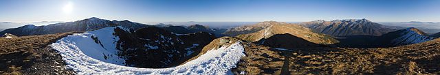
Polski: Panorama 360 stopni z głównego wierzchołka Kamienistej. English: A 360 degree view from the main summit of Veľká Kamenistá. |
| Date | |
| Source | Own work |
| Author | Rafał Kozubek |
| Other versions | z podpisami/with captions |
| 360° | View in 360° panoramic viewer
|
|---|
Licensing
[edit]
I, the copyright holder of this work, hereby publish it under the following license:
This file is licensed under the Creative Commons Attribution-Share Alike 3.0 Unported license.
- You are free:
- to share – to copy, distribute and transmit the work
- to remix – to adapt the work
- Under the following conditions:
- attribution – You must give appropriate credit, provide a link to the license, and indicate if changes were made. You may do so in any reasonable manner, but not in any way that suggests the licensor endorses you or your use.
- share alike – If you remix, transform, or build upon the material, you must distribute your contributions under the same or compatible license as the original.
File history
Click on a date/time to view the file as it appeared at that time.
| Date/Time | Thumbnail | Dimensions | User | Comment | |
|---|---|---|---|---|---|
| current | 12:06, 31 December 2011 | 20,215 × 3,465 (13.65 MB) | Rafik k (talk | contribs) |
You cannot overwrite this file.
File usage on Commons
There are no pages that use this file.
File usage on other wikis
The following other wikis use this file:
- Usage on de.wikipedia.org