File:Kaltohmfeld - Höchster Punkt 540 m - ehemalige Radarstation - panoramio.jpg
Jump to navigation
Jump to search

Size of this preview: 799 × 151 pixels. Other resolutions: 320 × 60 pixels | 2,000 × 378 pixels.
Original file (2,000 × 378 pixels, file size: 512 KB, MIME type: image/jpeg)
Captions
Captions
Add a one-line explanation of what this file represents
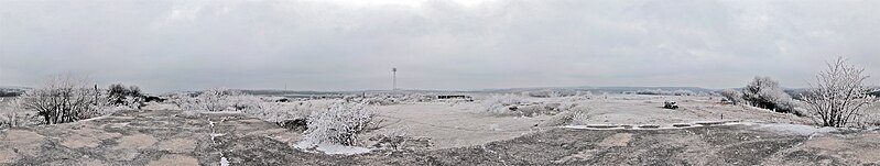
| Description | Kaltohmfeld - Höchster Punkt 540 m - ehemalige Radarstation | ||
| Date | 19 February 2011 (original upload date) | ||
| Source | https://web.archive.org/web/20161018030140/http://www.panoramio.com/photo/48368371 | ||
| Author | Renato Pietsch | ||
| Permission (Reusing this file) |
This file is licensed under the Creative Commons Attribution-Share Alike 3.0 Unported license. Attribution: Renato Pietsch
|
||
| Tags (from Panoramio photo page) | Leinefelde-Worbis, 2011, Deutschland, Leinefelde, Thüringen, Worbis |
| Camera location | | View this and other nearby images on: OpenStreetMap |
|---|
File history
Click on a date/time to view the file as it appeared at that time.
| Date/Time | Thumbnail | Dimensions | User | Comment | |
|---|---|---|---|---|---|
| current | 19:56, 12 November 2016 | 2,000 × 378 (512 KB) | Panoramio upload bot (talk | contribs) | {{Information |description=Kaltohmfeld - Höchster Punkt 540 m - ehemalige Radarstation |date={{Original upload date|2011-02-19}} |source=http://www.panoramio.com/photo/48368371 |author=[http://www.panoramio.com/user/5038562?with_photo_id=48368371 Rena... |
You cannot overwrite this file.
File usage on Commons
There are no pages that use this file.