File:Kaltenberg - Ortsansicht - 2.jpg
Original file (5,766 × 3,243 pixels, file size: 10.71 MB, MIME type: image/jpeg)
Captions
Summary
[edit]DescriptionKaltenberg - Ortsansicht - 2.jpg |
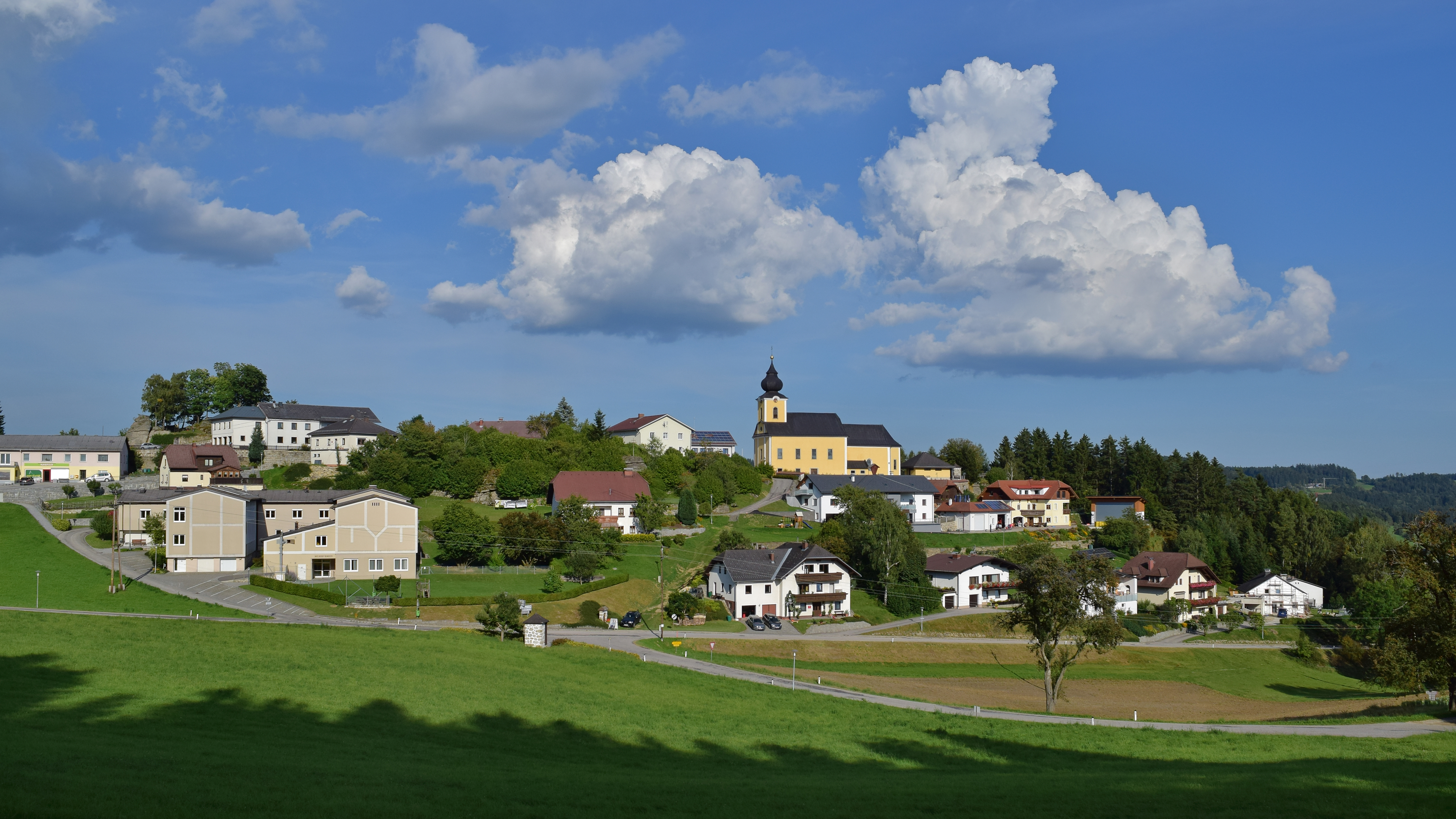
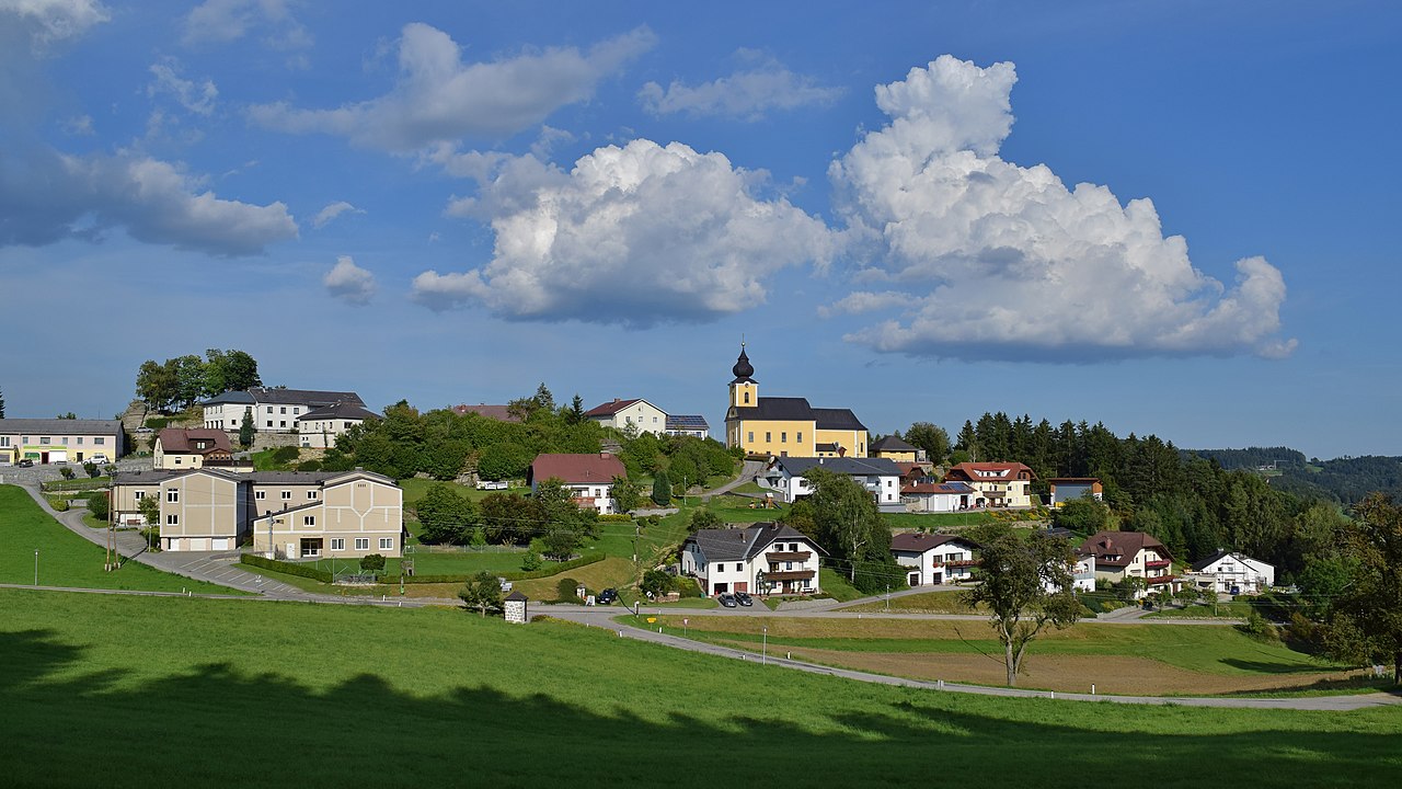
Deutsch: Ansicht der Gemeinde Kaltenberg
Kaltenberg (Oberösterreich) |
Date | |
Source | Own work |
Author | Haeferl |
Camera location | 48° 26′ 58.41″ N, 14° 46′ 22.56″ E | View this and other nearby images on: OpenStreetMap | 48.449558; 14.772933 |
---|
Licensing
[edit]- You are free:
- to share – to copy, distribute and transmit the work
- to remix – to adapt the work
- Under the following conditions:
- attribution – You must give appropriate credit, provide a link to the license, and indicate if changes were made. You may do so in any reasonable manner, but not in any way that suggests the licensor endorses you or your use.
- share alike – If you remix, transform, or build upon the material, you must distribute your contributions under the same or compatible license as the original.
Diese Datei wurde im Rahmen von WikiDaheim 2021 in Österreich erstellt und hochgeladen. Sie wurde dem Themenbereich Bilderwünsche zugeordnet. |
Annotations InfoField | This image is annotated: View the annotations at Commons |
Pfarrhof
Gemeindeamt
Volksschule
Kindergarten
Musikverein
Pfarr- und Wallfahrtskirche
Friedhofskapelle/Aufbahrungshalle
14. Kreuzwegstation
12. Kreuzwegstation
File history
Click on a date/time to view the file as it appeared at that time.
Date/Time | Thumbnail | Dimensions | User | Comment | |
---|---|---|---|---|---|
current | 13:09, 15 September 2021 | 5,766 × 3,243 (10.71 MB) | Haeferl (talk | contribs) | Uploaded own work with UploadWizard |
You cannot overwrite this file.
File usage on Commons
The following 3 pages use this file:
File usage on other wikis
The following other wikis use this file:
- Usage on ceb.wikipedia.org
- Usage on ce.wikipedia.org
- Usage on de.wikipedia.org
- Usage on eo.wikipedia.org
- Usage on es.wikipedia.org
- Usage on fr.wikipedia.org
- Usage on it.wikipedia.org
- Usage on lld.wikipedia.org
- Usage on lmo.wikipedia.org
- Usage on pl.wikipedia.org
- Usage on ru.wikipedia.org
- Usage on tt.wikipedia.org
- Usage on uz.wikipedia.org
- Usage on vec.wikipedia.org
- Usage on vo.wikipedia.org
- Usage on www.wikidata.org
Metadata
This file contains additional information such as Exif metadata which may have been added by the digital camera, scanner, or software program used to create or digitize it. If the file has been modified from its original state, some details such as the timestamp may not fully reflect those of the original file. The timestamp is only as accurate as the clock in the camera, and it may be completely wrong.
Camera manufacturer | NIKON CORPORATION |
---|---|
Camera model | NIKON D5300 |
Author | Haeferl |
Copyright holder |
|
Exposure time | 1/1,250 sec (0.0008) |
F-number | f/8 |
ISO speed rating | 100 |
Date and time of data generation | 16:43, 10 September 2021 |
Lens focal length | 18 mm |
Latitude | 48° 26′ 58.41″ N |
Longitude | 14° 46′ 22.56″ E |
Altitude | 834 meters above sea level |
City shown | Kaltenberg |
Orientation | Normal |
Horizontal resolution | 300 dpi |
Vertical resolution | 300 dpi |
Software used | Adobe Photoshop Elements 8.0 Windows |
File change date and time | 01:07, 14 September 2021 |
Y and C positioning | Centered |
Exposure Program | Aperture priority |
Exif version | 2.3 |
Date and time of digitizing | 16:43, 10 September 2021 |
Meaning of each component |
|
Image compression mode | 4 |
APEX exposure bias | −0.66666666666667 |
Maximum land aperture | 3.7 APEX (f/3.61) |
Metering mode | Center weighted average |
Light source | Unknown |
Flash | Flash did not fire |
DateTime subseconds | 10 |
DateTimeOriginal subseconds | 10 |
DateTimeDigitized subseconds | 10 |
Supported Flashpix version | 1 |
Color space | sRGB |
Sensing method | One-chip color area sensor |
File source | Digital still camera |
Scene type | A directly photographed image |
Custom image processing | Normal process |
Exposure mode | Auto exposure |
White balance | Auto white balance |
Digital zoom ratio | 1 |
Focal length in 35 mm film | 27 mm |
Scene capture type | Standard |
Scene control | None |
Contrast | Normal |
Saturation | Normal |
Sharpness | Normal |
Subject distance range | Unknown |
GPS time (atomic clock) | 14:43 |
Reference for direction of image | True direction |
Direction of image | 79.16 |
Geodetic survey data used | WGS-84 |
Latitude destination | 48° 27′ 0.05″ N |
Longitude of destination | 14° 46′ 35.46″ E |
GPS date | 10 September 2021 |
GPS tag version | 0.0.2.2 |
IIM version | 36,581 |
Keywords |
|
Province or state shown | Oberösterreich |
Code for country shown | AUT |
Country shown | Österreich |
Sublocation of city shown | Kaltenberg |
Supported Flashpix version | 1 |
Image width | 5,766 px |
Image height | 3,243 px |
Contact information | Haeferl@chello.at
http://commons.wikimedia.org/wiki/User:Haeferl
|
Date metadata was last modified | 03:07, 14 September 2021 |
Unique ID of original document | xmp.did:4C763E4EE714EC11830D9380A4E7016A |
Structured data
Items portrayed in this file
depicts
10 September 2021
48°26'58.409"N, 14°46'22.559"E
0.0008 second
18 millimetre
100
image/jpeg
- Files with coordinates missing SDC location of creation
- CC-BY-SA-4.0
- Self-published work
- Media from WikiDaheim 2021 in Austria/all
- Media from WikiDaheim 2021 in Austria/Bilderwunsch
- Images with annotations
- Media from WikiDaheim in Austria check done
- Images by Haeferl
- Taken with Nikon D5300
- Uploaded via Campaign:WikiDaheim-at-bw