File:Kaart zeebeving Indische Oceaan 2004.png
Jump to navigation
Jump to search

Size of this preview: 800 × 481 pixels. Other resolutions: 320 × 192 pixels | 640 × 385 pixels | 1,024 × 616 pixels | 1,500 × 902 pixels.
Original file (1,500 × 902 pixels, file size: 162 KB, MIME type: image/png)
Captions
Captions
Add a one-line explanation of what this file represents
| Description |
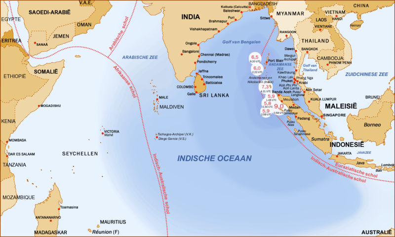
English: Earthquakes and aftershocks, Indian Ocean, 26.12.2004
Deutsch: Seebeben im Indischen Ozean am 26. Dezember 2004, Epizentren, schwere Nachbeben und betroffene Küsten.
Nederlands: Kaart van het gebied getroffen door de tsunami na zeebeving van 26 december 2004. |
| Date | 29 December 2004 (original upload date) |
| Source | Transferred from nl.wikipedia |
| Author | Manfred Werner (altered (translated) by Danielm) |
| Permission (Reusing this file) |
Released under the GNU Free Documentation License. |
| Other versions |
 (original, German) |
Licensing
[edit]

|
Permission is granted to copy, distribute and/or modify this document under the terms of the GNU Free Documentation License, Version 1.2 or any later version published by the Free Software Foundation; with no Invariant Sections, no Front-Cover Texts, and no Back-Cover Texts. A copy of the license is included in the section entitled GNU Free Documentation License. |
| This file is licensed under the Creative Commons Attribution-Share Alike 3.0 Unported license. | ||
| ||
| This licensing tag was added to this file as part of the GFDL licensing update. |
Original upload log
[edit]
The original description page was here. All following user names refer to nl.wikipedia.
- 2004-12-29 16:15 Danielm 1500×902× (166169 bytes) Vertaling Duitse kaart
File history
Click on a date/time to view the file as it appeared at that time.
| Date/Time | Thumbnail | Dimensions | User | Comment | |
|---|---|---|---|---|---|
| current | 12:17, 2 December 2009 | | 1,500 × 902 (162 KB) | BotMultichill (talk | contribs) | {{BotMoveToCommons|nl.wikipedia|year={{subst:CURRENTYEAR}}|month={{subst:CURRENTMONTHNAME}}|day={{subst:CURRENTDAY}}}} {{Information |Description={{nl|Kaart van het gebied getroffen door de tsunami na zeebeving van 26 december 2004. De kaart werd gemaa |
You cannot overwrite this file.
File usage on Commons
The following page uses this file:
File usage on other wikis
The following other wikis use this file:
- Usage on nl.wikipedia.org
- Usage on www.wikidata.org