File:Kaart van het land rondom Breda, 1624-1625, BI-B-FM-013B-4.jpg
Jump to navigation
Jump to search
Size of this preview: 800 × 551 pixels. Other resolutions: 320 × 221 pixels | 640 × 441 pixels | 1,024 × 706 pixels | 1,280 × 882 pixels | 2,560 × 1,764 pixels | 5,068 × 3,493 pixels.
Original file (5,068 × 3,493 pixels, file size: 3.94 MB, MIME type: image/jpeg)
Captions
Captions
Add a one-line explanation of what this file represents
Summary
[edit]
| Description |
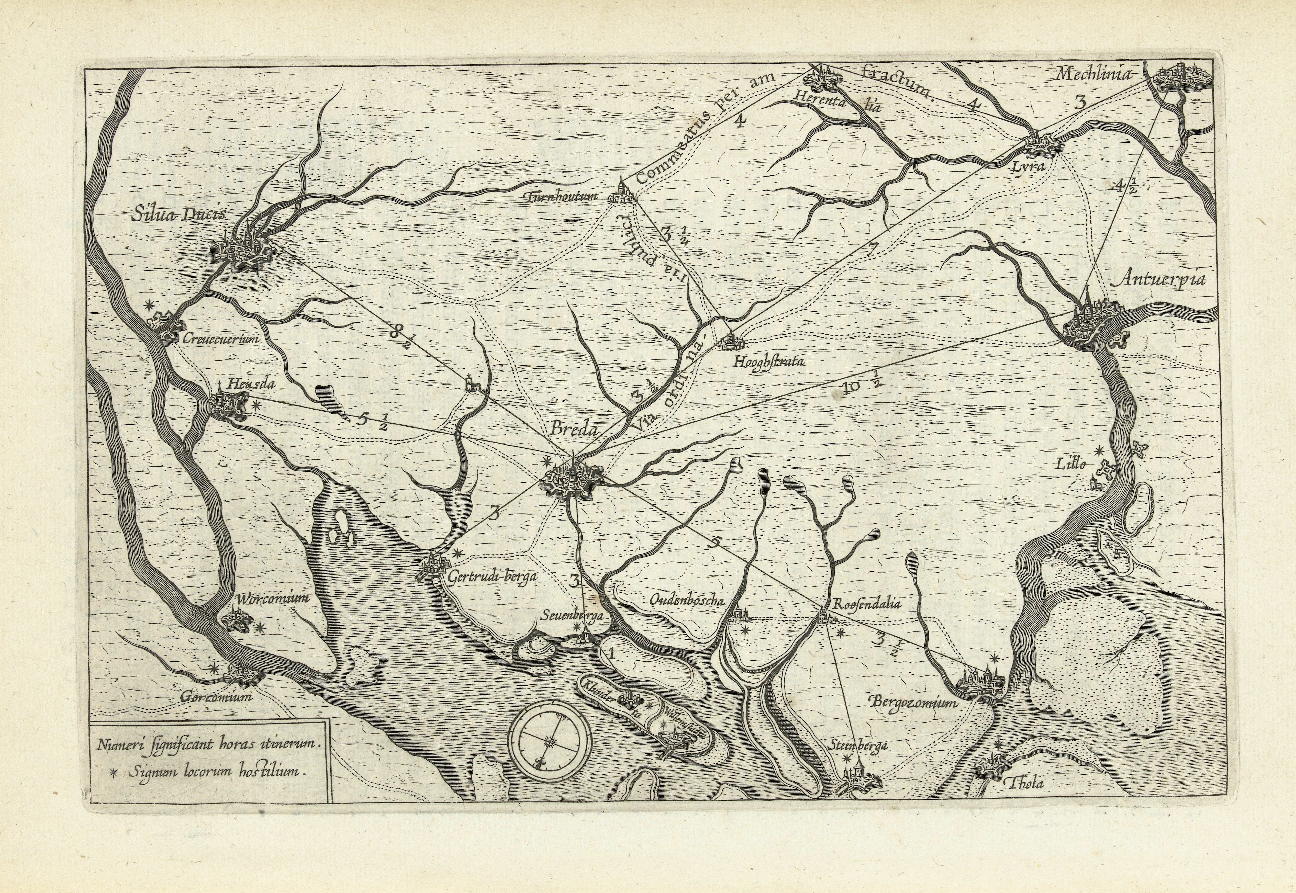
Nederlands: Identificatie Titel(s): Kaart van het land rondom Breda, 1624-1625 Objecttype: prent nieuwsprent kaart Objectnummer: BI-B-FM-013. B-4 Catalogusreferentie: FMH 1511-A/3. Atlas van Stolk 1603. Opmerking: Pag. 13 Omschrijving: Kaart van het land rondom Breda tussen Mechelen, Steenbergen en Den Bosch, waarop aangegeven de belangrijkste wegen en vaarwegen, 1624-1625. Vervaardiging Vervaardiger: prentmaker: anoniem, prentmaker: Theodoor Galle (mogelijk), prentmaker: Boëtius Adamsz. Bolswert (mogelijk), prentmaker: Schelte Adamsz. Bolswert (mogelijk) Plaats vervaardiging: Zuidelijke Nederlanden Datering: 1625 - 1626 Fysieke kenmerken: gravure Materiaal: papier Techniek: graveren (drukprocedé) Afmetingen: plaatrand: h 161 mm × b 246 mm Toelichting Illustratie in: Hermannus Hugo, Obsidio Bredana armis Philippi IIII avspiciis Isabellae Dvctv Ambr. Spinolae perfecta, ex off. Plantiniana, Antwerpen 1629, p. 12/13. Exemplaar in de collectie van de Rijksmuseum Research Library met signatuur 327 I 25. In M. Funck, Le livre belge à gravures : guide de l'amateur de livres illustrés imprimés en Belgique avant le XVIIIe siècle (1925) worden deze illustraties toegeschreven aan Theodoor Galle (11) en Schelte en Boëtius Bolswert (4). Ze worden echter in Hollstein niet bij deze prentmakers vermeld. Onderwerp Wat: maps of separate countries or regions. Beleg van Breda (1624-1625) Wanneer: 1624 - 1625. Waar. Breda Verwerving en rechten Verwerving: aankoop 1881 Copyright: Publiek domein |
| Date | between 1625 and 1626 |
| Source | http://hdl.handle.net/10934/RM0001.COLLECT.460596 |
| Author | Rijksmuseum |
Licensing
[edit]
| This file is made available under the Creative Commons CC0 1.0 Universal Public Domain Dedication. | |
| The person who associated a work with this deed has dedicated the work to the public domain by waiving all of their rights to the work worldwide under copyright law, including all related and neighboring rights, to the extent allowed by law. You can copy, modify, distribute and perform the work, even for commercial purposes, all without asking permission.
|
File history
Click on a date/time to view the file as it appeared at that time.
| Date/Time | Thumbnail | Dimensions | User | Comment | |
|---|---|---|---|---|---|
| current | 17:01, 3 March 2023 | | 5,068 × 3,493 (3.94 MB) | Pelikana (talk | contribs) | Cropped -13 % horizontally, 48 % vertically, rotated 270° using CropTool with lossless mode. |
| 18:37, 12 January 2020 |  | 4,488 × 6,666 (5.67 MB) | Mr.Nostalgic (talk | contribs) | == {{int:filedesc}} == {{Information |Description={{nl|1=<br><br><big>'''Identificatie'''</big><br>'''Titel(s): '''Kaart van het land rondom Breda, 1624-1625<br>'''Objecttype:''' prent nieuwsprent kaart <br>'''Objectnummer:''' BI-B-FM-013B-4<br>'''Catalogusreferentie:''' FMH 1511-A/3Atlas van Stolk 1603Opmerking: Pag. 13<br>'''Omschrijving:''' Kaart van het land rondom Breda tussen Mechelen, Steenbergen en Den Bosch, <br>'''Waar:''' op aangegeven de belangrijkste wegen en vaarwegen, 1624-1625... |
You cannot overwrite this file.
File usage on Commons
The following page uses this file: