File:KSBP diagram.png
Jump to navigation
Jump to search
Size of this preview: 412 × 599 pixels. Other resolutions: 165 × 240 pixels | 330 × 480 pixels | 766 × 1,114 pixels.
Original file (766 × 1,114 pixels, file size: 57 KB, MIME type: image/png)
Captions
Captions
Add a one-line explanation of what this file represents
| Description |
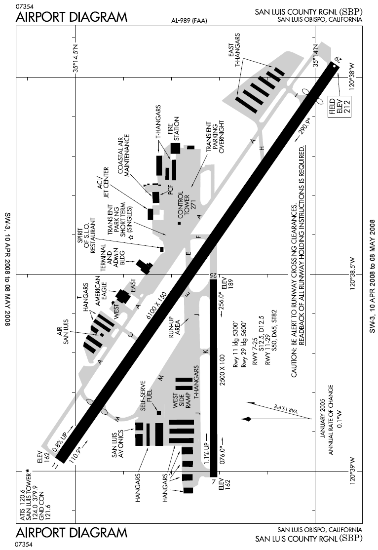
English: FAA diagram for San Luis Obispo County Regional Airport (KSBP) in San Luis Obispo, California, United States. Warning: this diagram contains material which is subject to change, do not use for navigation. |
| Date | Effective: April 2008 |
| Source |
http://204.108.4.16/d-tpp/0804/00989AD.PDF Note: this URL changes monthly; the airport article should contain a link to the current FAA diagram. |
| Author | National Aeronautical Charting Office (NACO), a department of the Federal Aviation Administration (FAA). |
| Permission (Reusing this file) |
Public Domain |
Licensing
[edit]
This image or file is a work of a Federal Aviation Administration employee, taken or made as part of that person's official duties. As a work of the U.S. federal government, the image is in the public domain in the United States.
|
 |
Original upload log
[edit]
Transferred from en.wikipedia to Commons by Quadell using CommonsHelper.
The original description page was here. All following user names refer to en.wikipedia.
- 2008-04-19 00:22 Csecse 766×1114× (57981 bytes) Current FAA Diagram as of April 10, 2008 - Source: http://204.108.4.16/d-tpp/0804/00989AD.PDF
- 2006-04-08 08:40 Zyxw 805×1237× (31918 bytes) FAA diagram of San Luis County Regional Airport (KSBP) as of 13-Apr-2006 http://www.naco.faa.gov/d-tpp/0604/00989AD.PDF
- 2005-12-16 01:02 Akhristov 467×672× (26362 bytes) Compressed
- 2005-11-09 01:38 Akhristov 467×672× (53066 bytes) Detail from FAA diagram of [[San Luis County Regional Airport]]. Warning, this diagram contains material which is subject to change, do not use for navigation.
File history
Click on a date/time to view the file as it appeared at that time.
| Date/Time | Thumbnail | Dimensions | User | Comment | |
|---|---|---|---|---|---|
| current | 20:31, 16 June 2009 | | 766 × 1,114 (57 KB) | File Upload Bot (Magnus Manske) (talk | contribs) | {{BotMoveToCommons|en.wikipedia|year={{subst:CURRENTYEAR}}|month={{subst:CURRENTMONTHNAME}}|day={{subst:CURRENTDAY}}}} {{Information |Description={{en|FAA diagram for en:San Luis Obispo County Regional Airport (KSBP) in San Luis Obispo, California, |
You cannot overwrite this file.
File usage on Commons
There are no pages that use this file.