File:KPA3-2a.jpg
Jump to navigation
Jump to search

Size of this preview: 800 × 499 pixels. Other resolutions: 320 × 200 pixels | 640 × 399 pixels | 832 × 519 pixels.
Original file (832 × 519 pixels, file size: 117 KB, MIME type: image/jpeg)
Captions
Captions
Add a one-line explanation of what this file represents
Summary
[edit]
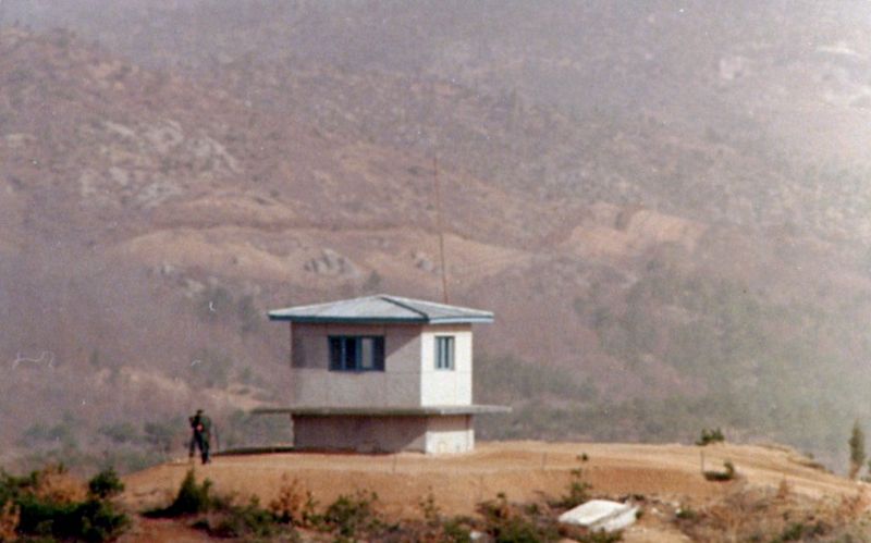
| Description | Another view of KPA#3. The North Korean boundary of the DMZ is clearly visible in the background. The clear area, which is on the south side of a fence, is the North Korean's minefield. The dirt is checked each day for any signs of footprints or other disturbances. (Photo January 1976) |
| Date | 7 January 2007 (original upload date) |
| Source | No machine-readable source provided. Own work assumed (based on copyright claims). |
| Author | No machine-readable author provided. Wbfergus assumed (based on copyright claims). |
Licensing
[edit]
| I, the copyright holder of this work, release this work into the public domain. This applies worldwide. In some countries this may not be legally possible; if so: I grant anyone the right to use this work for any purpose, without any conditions, unless such conditions are required by law. |
File history
Click on a date/time to view the file as it appeared at that time.
| Date/Time | Thumbnail | Dimensions | User | Comment | |
|---|---|---|---|---|---|
| current | 19:32, 24 April 2012 | | 832 × 519 (117 KB) | Hohum (talk | contribs) | Reworked from original. |
| 19:17, 5 October 2009 |  | 835 × 518 (106 KB) | Smurfy (talk | contribs) | Cropped, straightened, colour corrected and cleaned up. | |
| 17:58, 7 January 2007 |  | 900 × 604 (120 KB) | Wbfergus (talk | contribs) | Another view of KPA#3. The North Korean boundary of the DMZ is clearly visible in the background. The clear area, which is on the south side of a fence, is the North Korean's minefield. The dirt is checked each day for any signs of footprints or other dis |
You cannot overwrite this file.
File usage on Commons
The following page uses this file:
File usage on other wikis
The following other wikis use this file:
- Usage on bg.wikipedia.org
- Usage on en.wikipedia.org
- Usage on it.wikipedia.org
- Usage on no.wikipedia.org
- Usage on simple.wikipedia.org
- Usage on zh.wikipedia.org