File:KAM map 1300.jpg
Jump to navigation
Jump to search

Size of this preview: 671 × 599 pixels. Other resolutions: 269 × 240 pixels | 537 × 480 pixels | 860 × 768 pixels | 1,146 × 1,024 pixels | 2,293 × 2,048 pixels | 3,907 × 3,490 pixels.
Original file (3,907 × 3,490 pixels, file size: 2.88 MB, MIME type: image/jpeg)
Captions
Captions
Add a one-line explanation of what this file represents
| Lithuanian interwar maps, 1 : 100 000 | |||||||||||
|---|---|---|---|---|---|---|---|---|---|---|---|
 |
1000 | 1001 | 1002 | 1003 | 1004 | 1005 | 1006 | 1007 | 1008 | ||
| 1100 | 1101 | 1102 | 1103 | 1104 | 1105 | 1106 | 1107 | 1108 | 1109 | ||
| 1200 | 1201 | 1202 | 1203 | 1204 | 1205 | 1206 | 1207 | 1208 | 1209 | 1210 | |
| 1300 | 1301 | 1302 | 1303 | 1304 | 1305 | 1306 | 1307 | 1308 | 1309 | 1310 | |
| 1400 | 1401 | 1402 | 1403 | 1404 | 1405 | 1406 | 1407 | 1408 | 1409 | 1410 | |
| 1500 | 1501 | 1502 | 1503 | 1504 | 1505 | 1506 | 1507 | 1508 | 1509 | ||
| 1603 | 1604 | 1605 | 1606 | 1607 | 1608 | ||||||
| 1703 | 1704 | 1705 | 1706 | 1707 | 1708 | ||||||
| 1803 | 1804 | 1805 | 1806 | 1807 | 1808 | ||||||
| 1904 | 1905 | 1906 | 1907 | ||||||||
| 2004 | 2005 | ||||||||||
Summary
[edit]
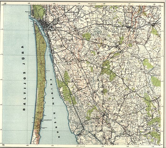
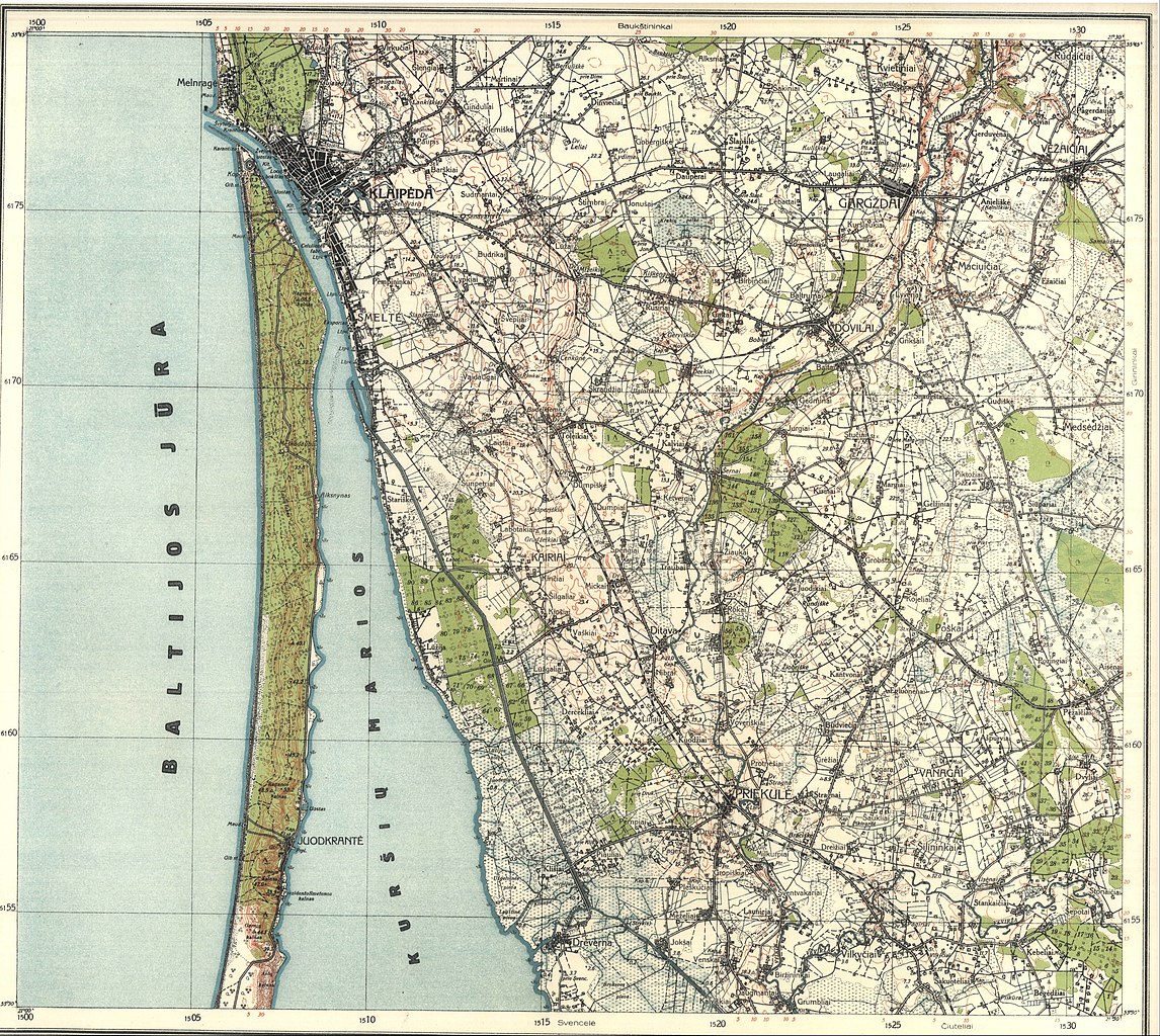
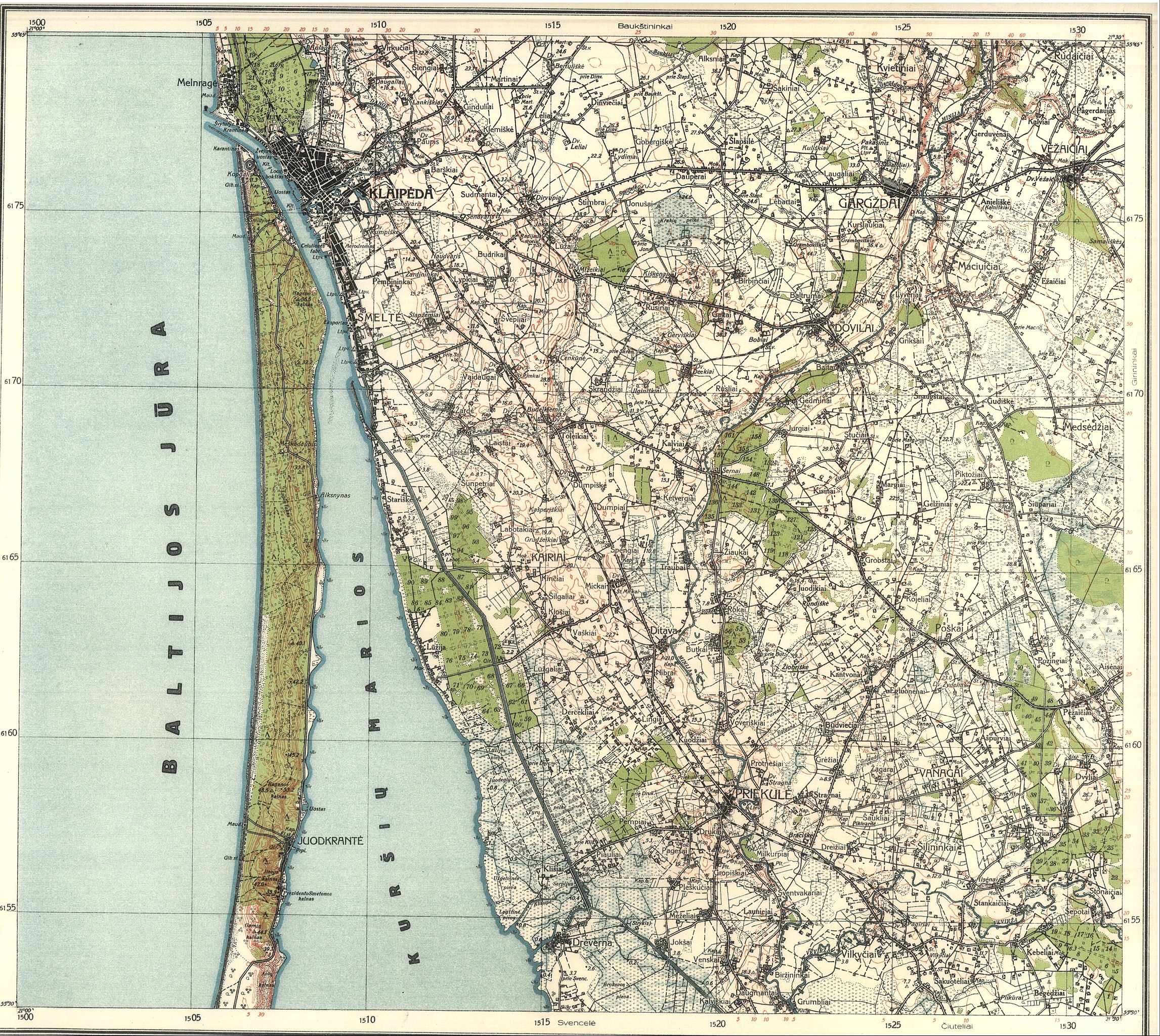
| Description | Lithuanian map, scale 1 : 100 000, page 1300 | ||||
| Date | circa 1935 | ||||
| Source | LithuanianMaps.com | ||||
| Author | Lietuvos karo topografijos skyrius | ||||
| Permission (Reusing this file) |
|
||||
File history
Click on a date/time to view the file as it appeared at that time.
| Date/Time | Thumbnail | Dimensions | User | Comment | |
|---|---|---|---|---|---|
| current | 17:31, 31 December 2021 | | 3,907 × 3,490 (2.88 MB) | CD (talk | contribs) | {{Information |Description=Lithuanian map, scale 1 : 100 000, page 1300 |Source=[http://lithuanianmaps.com/TopoMapsLithuanian1920-39.html LithuanianMaps.com] |Date={{other date|~|1935}} |Author=Lietuvos karo topografijos skyrius |Permission={{PD-old}} |other_versions= }} Category:Maps by Lithuanian war topography department (1 : 100 000) |
You cannot overwrite this file.
File usage on Commons
There are no pages that use this file.
File usage on other wikis
The following other wikis use this file:
- Usage on lt.wikipedia.org
Categories:
- Maps by Lithuanian war topography department (1 : 100 000)
- Dovilai in topographic maps
- Gargždai in topographic maps
- Klaipėda in topographic maps
- Priekulė in topographic maps
- Vėžaičiai in topographic maps
- Agluonėnai train station in maps
- Ažpurviai train station in maps
- Bachmanas train station in maps
- Baičiai train station in maps
- Barškiai train station in maps
- Baukštininkai train station in maps
- Bobiai train station in maps
- Dėckiai train station in maps
- Dinviečiai train station in maps
- Dirvupiai train station in maps
- Dovilai train station in maps
- Grambaviškiai train station in maps
- Grobštai train station in maps
- Jakai train station in maps
- Klaipėda train station in maps
- Klemiškė train station in maps
- Laugaliai train station in maps
- Margiai train station in maps
- Mickai train station in maps
- Mižeikiai train station in maps
- Pėžaičiai train station in maps
- Poškos train station in maps
- Priekulė train station in maps
- Rimkai train station in maps
- Stučiai train station in maps
- Vilkyčiai train station in maps
- Žydeliai train station in maps
- Žilupiai train station in maps