File:KAARTEN SGD - Aanleg van scheepvaartkanalen naar Twenthe.jpeg
Jump to navigation
Jump to search

Size of this preview: 432 × 600 pixels. Other resolutions: 173 × 240 pixels | 346 × 480 pixels | 553 × 768 pixels | 738 × 1,024 pixels | 2,051 × 2,847 pixels.
Original file (2,051 × 2,847 pixels, file size: 724 KB, MIME type: image/jpeg)
Captions
Captions
Add a one-line explanation of what this file represents
Summary
[edit]| Title |
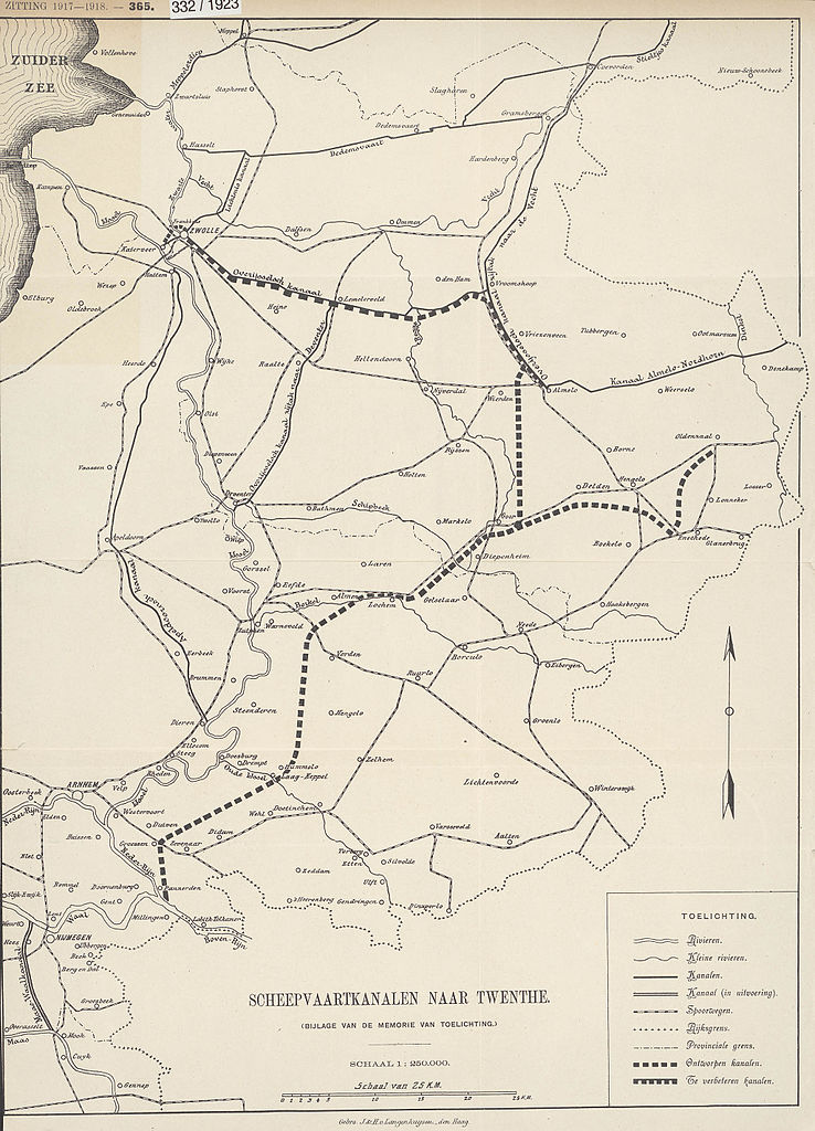
KAARTEN SGD - Aanleg van scheepvaartkanalen naar Twenthe |
||||||||||||||||||||||||||
| Description |
Op de kaart is een onderscheid gemaakt tussen bestaande kanalen, in uitvoering zijnde kanalen, ontworpen kanalen en te verbeteren kanalen. Door de toenemende textielnijverheid in Twente werd de noodzaak tot meer en betere verbindingen over water sterk gevoeld |
||||||||||||||||||||||||||
| Date | |||||||||||||||||||||||||||
| Source |
This image in context: http://www.statengeneraaldigitaal.nl/document?id=sgd:mpeg21:19171918:0002150&pagina=5;
|
||||||||||||||||||||||||||
| Creator |
English: The individual creators of this map are unknown, it was commissioned by the House of Representatives of the Netherlands.
Nederlands: De precieze makers van deze kaart zijn niet bekend, hij werd in opdracht van de Tweede Kamer der Staten-Generaal gemaakt. |
||||||||||||||||||||||||||
| Permission (Reusing this file) |
|
||||||||||||||||||||||||||
| Geotemporal data | |||||||||||||||||||||||||||
| Date depicted | |||||||||||||||||||||||||||
| Map location | Overijssel | ||||||||||||||||||||||||||
| Scale | 1:250.000 | ||||||||||||||||||||||||||
| Bounding box |
|
||||||||||||||||||||||||||
| Georeferencing | |||||||||||||||||||||||||||
| Bibliographic data | |||||||||||||||||||||||||||
| Publisher |
This map was commissioned and published by the
|
||||||||||||||||||||||||||
| Archival data | |||||||||||||||||||||||||||
| Collection |
This map was digitized by the
|
||||||||||||||||||||||||||
| Notes |
Nederlands: uitbreiding en onderhoud van vaarwegen |
||||||||||||||||||||||||||


File history
Click on a date/time to view the file as it appeared at that time.
| Date/Time | Thumbnail | Dimensions | User | Comment | |
|---|---|---|---|---|---|
| current | 13:05, 15 November 2015 | | 2,051 × 2,847 (724 KB) | OlafJanssen (talk | contribs) | GWToolset: Creating mediafile for OlafJanssen. |
You cannot overwrite this file.
File usage on Commons
There are no pages that use this file.
File usage on other wikis
The following other wikis use this file:
- Usage on nl.wikipedia.org