File:Köln-Ehrenfeld – 360°-Panorama aus der Luft (2019).jpg

Original file (8,192 × 4,096 pixels, file size: 14.04 MB, MIME type: image/jpeg)
Captions
Captions
Summary
[edit].jpg&action=edit§ion=1)
| Description |
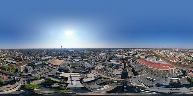
Deutsch: Das Foto zeigt einen Teil des Kölner Stadtteils Ehrenfeld von oben, in Rundum-Ansicht.
Zur Orientierung: Im Osten ist der Fernsehturm zu sehen, rechts davon, leicht verdeckt, die beiden Domspitzen. Die Bahngeleise führen vom Hauptbahnhof über den Bahnhof Ehrenfeld nach Westen, Richtung Aachen. Der Bahnhof Ehrenfeld ist im Nordosten deutlich zu erkennen. Direkt davor befindet sich der Leuchtturm der Heliosstraße (Helios-Leuchtturm). Rechts vom Leuchtturm stößt die Heliusstraße auf die Vogelsangerstraße, die an den Bahngeleisen im Westen beginnt und, hier im gleisenden Sonnenlicht, direkt ins Zentrum Kölns führt. Sie kreuzt dabei den an den Baumreihen erkennbaren Ehrenfeldgürtel, der rechts (also Richtung Süden) nach Lindental und links (also Richtung Norden) nach Nippes führt. Weit im Westen am Horizont sind mehrere Kohlekraftwerke zu sehen, dahinter die Umrisse der Eifel.English: This 360° drone shot shows parts of the Cologne district of Ehrenfeld. |
| Date | |
| Source | Own work |
| Author | Maximilian Schönherr |
Licensing
[edit].jpg&action=edit§ion=2)
- You are free:
- to share – to copy, distribute and transmit the work
- to remix – to adapt the work
- Under the following conditions:
- attribution – You must give appropriate credit, provide a link to the license, and indicate if changes were made. You may do so in any reasonable manner, but not in any way that suggests the licensor endorses you or your use.
- share alike – If you remix, transform, or build upon the material, you must distribute your contributions under the same or compatible license as the original.
| 360° | View in 360° panoramic viewer
|
|---|
.jpg)
[[Category:Spherical panoramics]
File history
Click on a date/time to view the file as it appeared at that time.
| Date/Time | Thumbnail | Dimensions | User | Comment | |
|---|---|---|---|---|---|
| current | 09:40, 11 April 2019 | | 8,192 × 4,096 (14.04 MB) | Maximilian Schönherr (talk | contribs) | User created page with UploadWizard |
You cannot overwrite this file.
File usage on Commons
There are no pages that use this file.
File usage on other wikis
The following other wikis use this file:
- Usage on de.wikipedia.org
.jpg&oldid=495418569)