File:Journey Behind the Falls, Niagara Falls, Ontario (29871590012).jpg
Original file (4,000 × 3,000 pixels, file size: 3.14 MB, MIME type: image/jpeg)
Captions
Captions
Summary
[edit].jpg&action=edit§ion=1)
| Description |
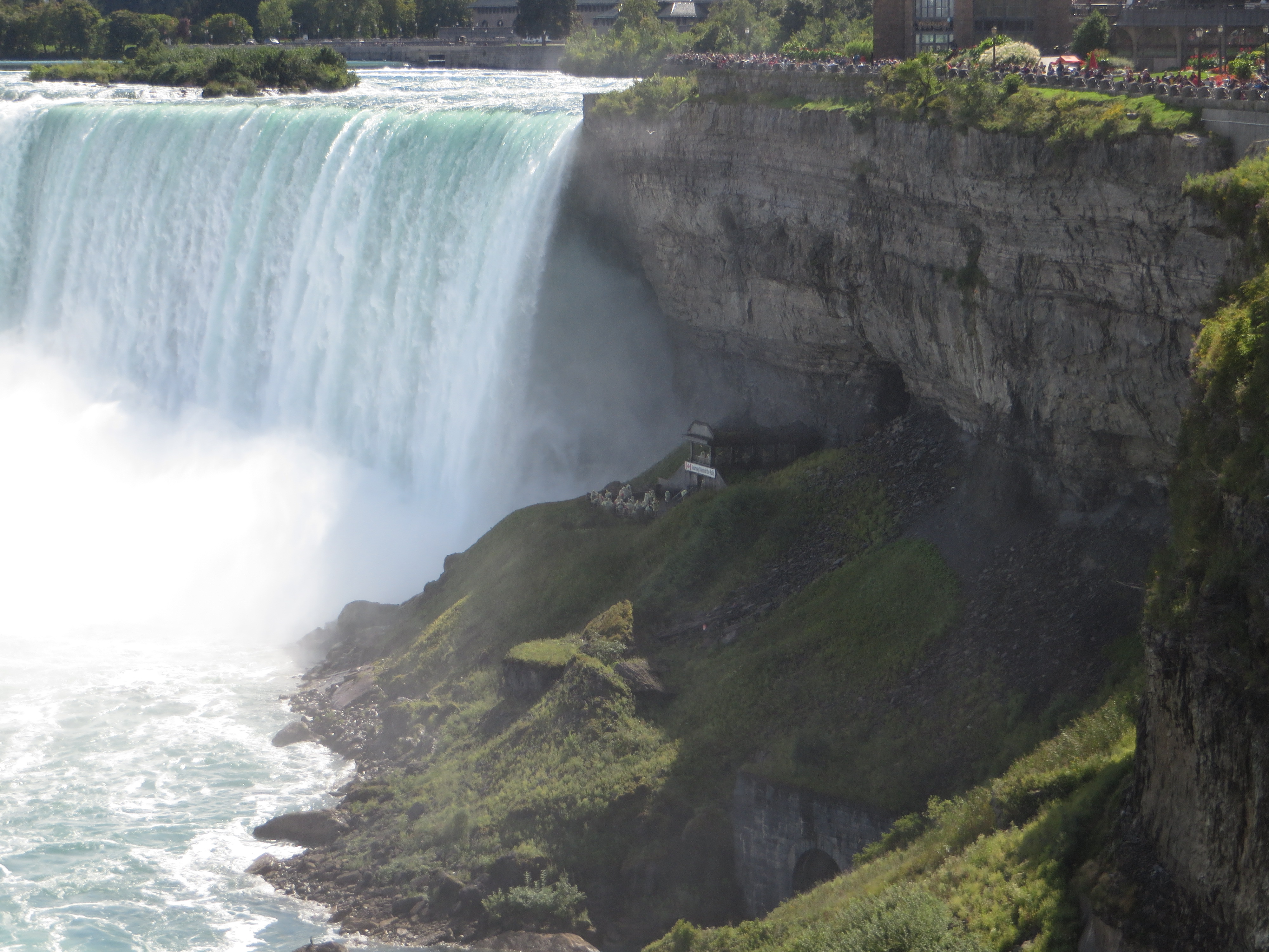
Journey Behind the Falls (known until the early 1990s as the Scenic Tunnels) is an attraction in Niagara Falls, Ontario, Canada located in the Table Rock Centre beside the Canadian Horseshoe Falls. It is open year round and run by the Niagara Parks Commission. Journey consists of an observation platform and series of tunnels near the bottom of the Horseshoe Falls on the Canadian shore of the Niagara River. The tunnels and platform can be reached by elevators from the street level entrance. The tour is unguided. The two tunnels extend approximately 46 metres (151 ft) behind the waterfall and allow visitors to view water cascading in front of the open cave entrances. Earlier in the attraction's history visitors were permitted far closer to the portals' edge, however, the ongoing erosion of the gorge itself left these areas with insufficient rock remaining on the sides, and new tunnels were built further back.[1] Barricades now exist further back from the ledge at the end of the tunnels to ensure visitor safety. The observation deck provides a vantage point looking up with the falls to the right, allowing photographers a full view of the famous landmark. The deck is sprayed with water from the cascade so visitors are provided with plastic raincoats prior to their descent. <a href="https://en.wikipedia.org/wiki/Journey_Behind_the_Falls" rel="noreferrer nofollow">en.wikipedia.org/wiki/Journey_Behind_the_Falls</a> <a href="https://en.wikipedia.org/wiki/Wikipedia:Text_of_Creative_Commons_Attribution-ShareAlike_3.0_Unported_License" rel="noreferrer nofollow">en.wikipedia.org/wiki/Wikipedia:Text_of_Creative_Commons_...</a> |
| Date | |
| Source | Journey Behind the Falls, Niagara Falls, Ontario |
| Author | Ken Lund from Reno, Nevada, USA |
| Camera location | | View this and other nearby images on: OpenStreetMap |
|---|
.jpg¶ms=043.082313_N_-079.077606_E_globe:Earth_type:camera_source:Flickr_&language=en)
Licensing
[edit].jpg&action=edit§ion=2)
- You are free:
- to share – to copy, distribute and transmit the work
- to remix – to adapt the work
- Under the following conditions:
- attribution – You must give appropriate credit, provide a link to the license, and indicate if changes were made. You may do so in any reasonable manner, but not in any way that suggests the licensor endorses you or your use.
- share alike – If you remix, transform, or build upon the material, you must distribute your contributions under the same or compatible license as the original.
| This image was originally posted to Flickr by Ken Lund at https://flickr.com/photos/75683070@N00/29871590012. It was reviewed on 10 March 2022 by FlickreviewR 2 and was confirmed to be licensed under the terms of the cc-by-sa-2.0. |
File history
Click on a date/time to view the file as it appeared at that time.
| Date/Time | Thumbnail | Dimensions | User | Comment | |
|---|---|---|---|---|---|
| current | 19:26, 10 March 2022 | | 4,000 × 3,000 (3.14 MB) | Mindmatrix (talk | contribs) | Transferred from Flickr via #flickr2commons |
You cannot overwrite this file.
File usage on Commons
There are no pages that use this file.
.jpg&oldid=896143392)