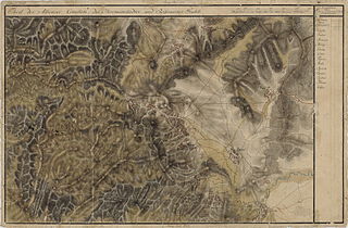
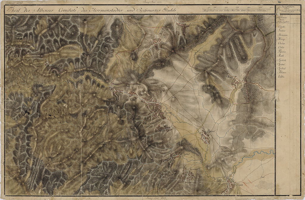
File:Josephinische Landaufnahme pg219.jpg
Jump to navigation
Jump to search

Size of this preview: 800 × 526 pixels. Other resolutions: 320 × 210 pixels | 640 × 421 pixels | 1,024 × 673 pixels | 1,280 × 841 pixels | 2,560 × 1,682 pixels | 8,381 × 5,508 pixels.
Original file (8,381 × 5,508 pixels, file size: 25.83 MB, MIME type: image/jpeg)
Captions
Captions
Add a one-line explanation of what this file represents
| Name shown on the map Nume din hartă |
Administrative unit Unitate administrativă |
Romanian name Numele românesc |
Hungarian name Numele unguresc |
German name Numele german |
Country today Ţara de astăzi |
|---|---|---|---|---|---|
| Pojana | Szerdahely szék Reussmarkter Stuhl Scaunul Miercurea |
Poiana Sibiului | Polyán | Pojana | Romania |
| Etsellõ | Szerdahely szék Reussmarkter Stuhl Scaunul Miercurea |
Aciliu | Ecsellő | Tetscheln | Romania |
| Tiliska | Fehér megye Komitat Unterweißenburg Comitatul Alba de Jos |
Tilişca | Tilicske | Tilischen | Romania |
| Gallis | Fehér megye Komitat Unterweißenburg Comitatul Alba de Jos |
Galeş | Szebengálos | Gallusdorf | Romania |
| Omlás | Fehér megye Komitat Unterweißenburg Comitatul Alba de Jos |
Amnaş | Omlás | Hamlesch | Romania |
| Szibiel | Fehér megye Komitat Unterweißenburg Comitatul Alba de Jos |
Sibiel [în Mărginimea Sibiului] | Szibiel | Budenbach, Biddenbach | Romania |
| Kákova | Fehér megye Komitat Unterweißenburg Comitatul Alba de Jos |
Fântânele [Cacova Sibiului, Cacova] în Mărginimea Sibiului | Szebenkákova | Krebsbach | Romania |
| Máág | Fehér megye Komitat Unterweißenburg Comitatul Alba de Jos |
Mag [Cernavoda] | Mág | Schardörfel, Schardörfl, Schwarzwasser | Romania |
| Roth | Fehér megye Komitat Unterweißenburg Comitatul Alba de Jos |
Rod | Ród, Veresegyház | Rodt, Rode, Roth, Rod [in Unterwaldes, Königsboden] | Romania |
| Szeliste | Fehér megye Komitat Unterweißenburg Comitatul Alba de Jos |
Sălişte [în Mărginimea Sibiului] | Szelistye | Grossdorf, Langendorf, Langesdorf | Romania |
| Szetsel | Fehér megye Komitat Unterweißenburg Comitatul Alba de Jos |
Săcel [Cernadia] | Szecsel, Feketevíz | Schwarzwasser | Romania |
| Vallie | Fehér megye Komitat Unterweißenburg Comitatul Alba de Jos |
Vale [Valea, Folteşti] [în Mărginimea Sibiului] | Vále, Válya | Grabendorf, Garuendorf | Romania |
Summary
[edit]
| Description |
English: Grand Duchy of Transylvania, 1769-1773. Josephinische Landaufnahme pg.219 Română: Harta Iosefină a Transilvaniei, 1769-1773. Josephinische Landaufnahme pg.219 |
||||
| Date | between 1769 and 1773 | ||||
| Source | Österreichisches Staatsarchiv, Kriegsarchiv, B IX 715: Original-Aufnahmskarte des Grossfürtenthums Siebenbürgen. Geometrisch aufgenommen und bearbeitet in den Jahren 1769 bis 1773 unter der Direction des Obristen von Fabris, theils durch Officiere des grossen Feld-Generalstabes, theils auch von verschiedenen aus dem in Siebenbürgen bequartierten Regimentern zu diesem Geschäfte beigezogenen Individuen | ||||
| Author | Historische Militärkarte der österreichisch-ungarischen Monarchie | ||||
| Permission (Reusing this file) |
|
||||
Clickable Map of the Grand Duchy of Transylvania
[edit]
File history
Click on a date/time to view the file as it appeared at that time.
| Date/Time | Thumbnail | Dimensions | User | Comment | |
|---|---|---|---|---|---|
| current | 08:24, 28 December 2009 | | 8,381 × 5,508 (25.83 MB) | Asybaris01 (talk | contribs) | new rez |
| 07:23, 9 December 2009 |  | 8,381 × 5,508 (41.42 MB) | Asybaris01 (talk | contribs) | good rezolution | |
| 11:50, 3 October 2009 |  | 5,448 × 3,580 (17.39 MB) | Asybaris01 (talk | contribs) | {{Information |Description={{ro|1=Josephinische Landaufnahme pg219}} |Source=Josephinische Landaufnahme pg219 |Author=Asybaris01 |Date=10/03/2009 |Permission= |other_versions= }} |
You cannot overwrite this file.
File usage on Commons
The following page uses this file:
File usage on other wikis
The following other wikis use this file:
- Usage on hu.wikipedia.org
- Usage on ro.wikipedia.org
- Usage on tt.wikipedia.org
- Usage on www.wikidata.org