File:Josephinische Landaufnahme pg173.jpg
Jump to navigation
Jump to search

Size of this preview: 800 × 523 pixels. Other resolutions: 320 × 209 pixels | 640 × 419 pixels | 1,024 × 670 pixels | 1,280 × 837 pixels | 2,560 × 1,675 pixels | 8,425 × 5,511 pixels.
Original file (8,425 × 5,511 pixels, file size: 25.87 MB, MIME type: image/jpeg)
Captions
Captions
Add a one-line explanation of what this file represents
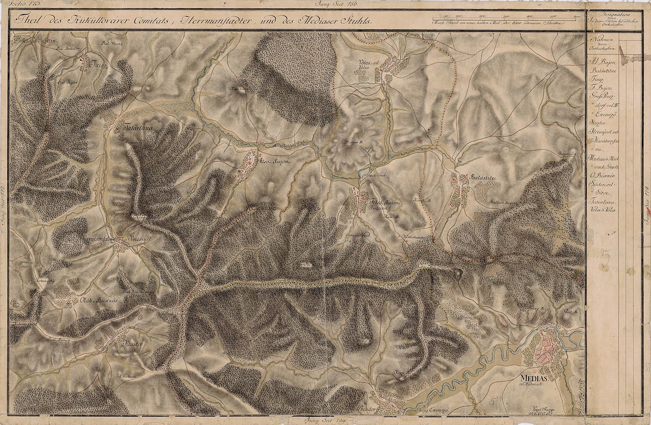
| Name shown on the map Nume din hartă |
Administrative unit Unitate administrativă |
Romanian name Numele românesc |
Hungarian name Numele unguresc |
German name Numele german |
Country today Ţara de astăzi |
|---|---|---|---|---|---|
| Seiden v Siitve | Küküllõ megye Komitat Kokelburg Comitatul Târnava |
Jidvei | Zsidve | Seiden, Sögden | Romania |
| Faisz | Küküllõ megye | Feisa | Küküllõfajsz | Füssen, Füselen, Fützen | Romania |
| Tatárlaka | Küküllõ megye | Tătârlaua | Felsõtatárlaka | Taterloch, Tatarloch, Taterlau, Tatarlau | Romania |
| Also Bajom | Küküllõ megye | Boian | Alsóbajom | Bonnesdorf | Romania |
| Vötes vel Voles | Medgyes szék (Zwei Stühle) Mediascher Stuhl Schelker Stuhl (Două Scaune) Scaunul Mediaşului Scaunul Şeica |
Velţ | Velc | Wölz, Wälzen, Thalheim [in Weinland, Königsboden] | Romania |
| Felsõ Bajom, Buzzen | Medgyes szék | Bazna | Bázna, Felsőbajom, Bajom | Baaßen, Bossern, Brassen, Brossen, Oberbassen [in Weinland, Königsboden] | Romania |
| Balástelke | Küküllõ megye | Blăjel | Balázstelke, Felsőbalázstelke, Balástelke | Klein-Blasendorf | Romania |
| Medias vel Medwisch | Medgyes szék | Mediaş | Medgyes | Mediasch, Medwisch [in Weinland, Königsboden] | Romania |
| Gros Prosdorff, Nagy Ekemezõ | Szeben szék Hermannstädter Stuhl Scaunul Sibiului |
Târnava | Nagyekemező, Ekemező, Prépostfalva | Groß-Probstdorf | Romania |
| Keszler | Küküllõ megye | Chesler | Keszlér | Kesseln, Keszlen, Kesselr | Romania |
| Oláh Bükkös | Küküllõ megye | Făget | Oláhbükkös | Birkendorf, Birkenwald | Romania |
| Karátsonfalva v Kreesivel | Küküllõ megye | Crăciunelu de Sus | Felsőkarácsonfalva, Oláhkarácsonfalva, Karácsonfalva | Christendorf, Krotschendorf | Romania |
Summary
[edit]
| Description |
English: Grand Duchy of Transylvania, 1769-1773. Josephinische Landaufnahme pg.173 Română: Harta Iosefină a Transilvaniei, 1769-1773. Josephinische Landaufnahme pg.173 |
||||
| Date | between 1769 and 1773 | ||||
| Source | Österreichisches Staatsarchiv, Kriegsarchiv, B IX 715: Original-Aufnahmskarte des Grossfürtenthums Siebenbürgen. Geometrisch aufgenommen und bearbeitet in den Jahren 1769 bis 1773 unter der Direction des Obristen von Fabris, theils durch Officiere des grossen Feld-Generalstabes, theils auch von verschiedenen aus dem in Siebenbürgen bequartierten Regimentern zu diesem Geschäfte beigezogenen Individuen | ||||
| Author | Historische Militärkarte der österreichisch-ungarischen Monarchie | ||||
| Permission (Reusing this file) |
|
||||
Clickable Map of the Grand Duchy of Transylvania
[edit]
File history
Click on a date/time to view the file as it appeared at that time.
| Date/Time | Thumbnail | Dimensions | User | Comment | |
|---|---|---|---|---|---|
| current | 07:43, 8 December 2009 | | 8,425 × 5,511 (25.87 MB) | Asybaris01 (talk | contribs) | good rezolution |
| 19:34, 4 November 2009 |  | 5,476 × 3,582 (17.25 MB) | Asybaris01 (talk | contribs) | {{Information |Description={{ro|1=Josephinische Landaufnahme pg173}} |Source=Josephinische Landaufnahme pg173 |Author=Asybaris01 |Date=2009/11/04 |Permission= |other_versions= }} |
You cannot overwrite this file.
File usage on Commons
The following page uses this file:
File usage on other wikis
The following other wikis use this file:
- Usage on arz.wikipedia.org
- Usage on de.wikipedia.org
- Usage on hu.wikipedia.org
- Usage on ro.wikipedia.org
- Usage on tt.wikipedia.org
- Usage on www.wikidata.org