File:Josephinische Landaufnahme pg070.jpg
Jump to navigation
Jump to search

Size of this preview: 800 × 532 pixels. Other resolutions: 320 × 213 pixels | 640 × 426 pixels | 1,024 × 681 pixels | 1,280 × 852 pixels | 2,560 × 1,703 pixels | 8,934 × 5,944 pixels.
Original file (8,934 × 5,944 pixels, file size: 26.94 MB, MIME type: image/jpeg)
Captions
Captions
Add a one-line explanation of what this file represents
| Warning | The original file is very high-resolution. It might not load properly or could cause your browser to freeze when opened at full size. |
|---|
| Name shown on the map Nume din hartă |
Administrative unit Unitate administrativă |
Romanian name Numele românesc |
Hungarian name Numele unguresc |
German name Numele german |
Country today Ţara de astăzi |
|---|---|---|---|---|---|
| Szent Király vel Kalota Szent Király | Kolozs megye Komitat Klausenburg Comitatul Cluj |
Sâncraiu | Kalotaszentkirály | Romania | |
| Zentelke | Kolozs megye | Zam | Zentelkeszentkirály | Kalotaszeg | Romania |
| Dános | Kolozs megye | Domoşu | Kalotadámos | Kleinbistritz | Romania |
| Nyarszo | Kolozs megye | Nearşova | Nyárszó | Romania | |
| Körös Fö | Kolozs megye | Izvoru Crişului | Körösfő | Romania | |
| Nados | Kolozs megye | Nadăşu | Kalotanádas | Romania | |
| Jegenye | Kolozs megye | Leghia | Jegenye | Tannendorf | Romania |
| Deritse | Kolozs megye | Dretea | Deréte | Romania | |
| Jakotelke | Kolozs megye | Horlacea | Jákótelke | Jakesteig | Romania |
| Kalota | Kolozs megye | Călata | Nagykalota | Romania | |
| Bökény | Kolozs megye | Buteni | Kalotabökény | Krumpendorf | Romania |
| Czula | Kolozs megye | Ciuleni | Incsel | Romania | |
| Valko | Kolozs megye | Văleni | Magyarvalkó | Gorisdorf | Romania |
| Oláh Bikal | Kolozs megye | Bica | Kalotabikal | Romania | |
| Erdőfalva | Kolozs megye | Ardeova | Erdőfalva | Walddorf | Romania |
| Nagy Monostor | Kolozs megye | Mănăstireni | Magyargyerőmonostor | Klosterdorf | Romania |
| Bedets | Kolozs megye | Bedeciu | Bedecs | Romania | |
| Pányik | Kolozs megye | Păniceni | Gyerőfalva | Romania | |
| Gyerö Vásárhelly | Kolozs megye | Dumbrava | Gyerővásárhely | Markendorf | Romania |
| Olah Monostor | Kolozs megye | Mănăşturu Românesc | Felsőgyerőmonsotor | Romania | |
| Kelentzel | Kolozs megye | Călăţele | Kiskalota | Kelezel | Romania |
| Ujfalu vel Kalota Ujfalu | Kolozs megye | Finciu | Kalotaújfalu | Neudorf | Romania |
Summary
[edit]
| Description |
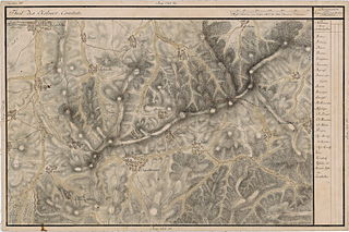
English: Grand Duchy of Transylvania, 1769-1773. Josephinische Landaufnahme pg.070 Română: Harta Iosefină a Transilvaniei, 1769-1773. Josephinische Landaufnahme pg.070 |
||||
| Date | between 1769 and 1773 | ||||
| Source | Österreichisches Staatsarchiv, Kriegsarchiv, B IX 715: Original-Aufnahmskarte des Grossfürtenthums Siebenbürgen. Geometrisch aufgenommen und bearbeitet in den Jahren 1769 bis 1773 unter der Direction des Obristen von Fabris, theils durch Officiere des grossen Feld-Generalstabes, theils auch von verschiedenen aus dem in Siebenbürgen bequartierten Regimentern zu diesem Geschäfte beigezogenen Individuen | ||||
| Author | Historische Militärkarte der österreichisch-ungarischen Monarchie | ||||
| Permission (Reusing this file) |
|
||||
Clickable Map of the Grand Duchy of Transylvania
[edit]
File history
Click on a date/time to view the file as it appeared at that time.
| Date/Time | Thumbnail | Dimensions | User | Comment | |
|---|---|---|---|---|---|
| current | 09:44, 4 December 2009 | | 8,934 × 5,944 (26.94 MB) | Asybaris01 (talk | contribs) | good rezolution |
| 06:27, 23 October 2009 |  | 5,807 × 3,864 (18.43 MB) | Asybaris01 (talk | contribs) | {{Information |Description={{ro|1=Josephinische Landaufnahme pg70}} |Source=Josephinische Landaufnahme pg70 |Author=Asybaris01 |Date=2009/10/23 |Permission= |other_versions= }} |
You cannot overwrite this file.
File usage on Commons
There are no pages that use this file.
File usage on other wikis
The following other wikis use this file:
- Usage on arz.wikipedia.org
- Usage on hu.wikipedia.org
- Usage on it.wikipedia.org
- Usage on ro.wikipedia.org
- Dretea, Cluj
- Dumbrava, Cluj
- Păniceni, Cluj
- Comuna Călățele, Cluj
- Ardeova, Cluj
- Bedeciu, Cluj
- Bica, Cluj
- Buteni, Cluj
- Ciuleni, Cluj
- Domoșu, Cluj
- Finciu, Cluj
- Horlacea, Cluj
- Comuna Izvoru Crișului, Cluj
- Leghia, Cluj
- Comuna Mănăstireni, Cluj
- Mănășturu Românesc, Cluj
- Nadășu, Cluj
- Nearșova, Cluj
- Comuna Sâncraiu, Cluj
- Văleni (Călățele), Cluj
- Călata, Cluj
- Sâncraiu, Cluj
- Călățele, Cluj
- Usage on tt.wikipedia.org
- Usage on www.wikidata.org