File:Josephinische Landaufnahme Varasdi.jpg
Jump to navigation
Jump to search

Size of this preview: 800 × 561 pixels. Other resolutions: 320 × 224 pixels | 640 × 449 pixels | 1,024 × 718 pixels | 1,280 × 897 pixels | 1,625 × 1,139 pixels.
Original file (1,625 × 1,139 pixels, file size: 146 KB, MIME type: image/jpeg)
Captions
Captions
Add a one-line explanation of what this file represents
Summary
[edit]
| Description |
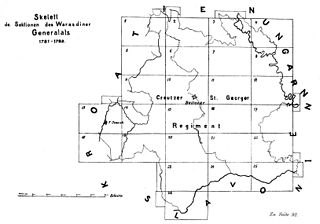
Română: Harta generală a Districtului Varasdi în hărţile iozefine, executată între anii 1781-82 |
||||
| Date | between 1781 and 1782 | ||||
| Source | Österreichisches Staatsarchiv, Kriegsarchiv | ||||
| Author | Historische Militärkarte der österreichisch-ungarischen Monarchie | ||||
| Permission (Reusing this file) |
|
||||
File history
Click on a date/time to view the file as it appeared at that time.
| Date/Time | Thumbnail | Dimensions | User | Comment | |
|---|---|---|---|---|---|
| current | 12:07, 1 December 2009 | | 1,625 × 1,139 (146 KB) | Asybaris01 (talk | contribs) | {{Information |Description={{ro|1=Harta generală a Districtului Varasdi în hărţile iozefine, executată între anii 1781-82}} |Source=Österreichisches Staatsarchiv, Kriegsarchiv |Author=Asybaris01 |Date=12/1/2009 |Permission= |oth |
You cannot overwrite this file.
File usage on Commons
The following 3 pages use this file:
.png)
File usage on other wikis
The following other wikis use this file:
- Usage on de.wikipedia.org
- Usage on es.wikipedia.org
- Usage on ro.wikipedia.org