File:Joseph Moxon, The travels of St. Paul and other the Apostles or a geographical description of those lands and countries where in the Gospel of Christ was first propagated (FL200067343 2368802).jpg
Jump to navigation
Jump to search
Size of this preview: 800 × 545 pixels. Other resolutions: 320 × 218 pixels | 640 × 436 pixels | 1,024 × 698 pixels | 1,280 × 873 pixels | 2,560 × 1,746 pixels | 6,852 × 4,672 pixels.
Original file (6,852 × 4,672 pixels, file size: 51.48 MB, MIME type: image/jpeg)
Captions
Captions
Add a one-line explanation of what this file represents
Summary
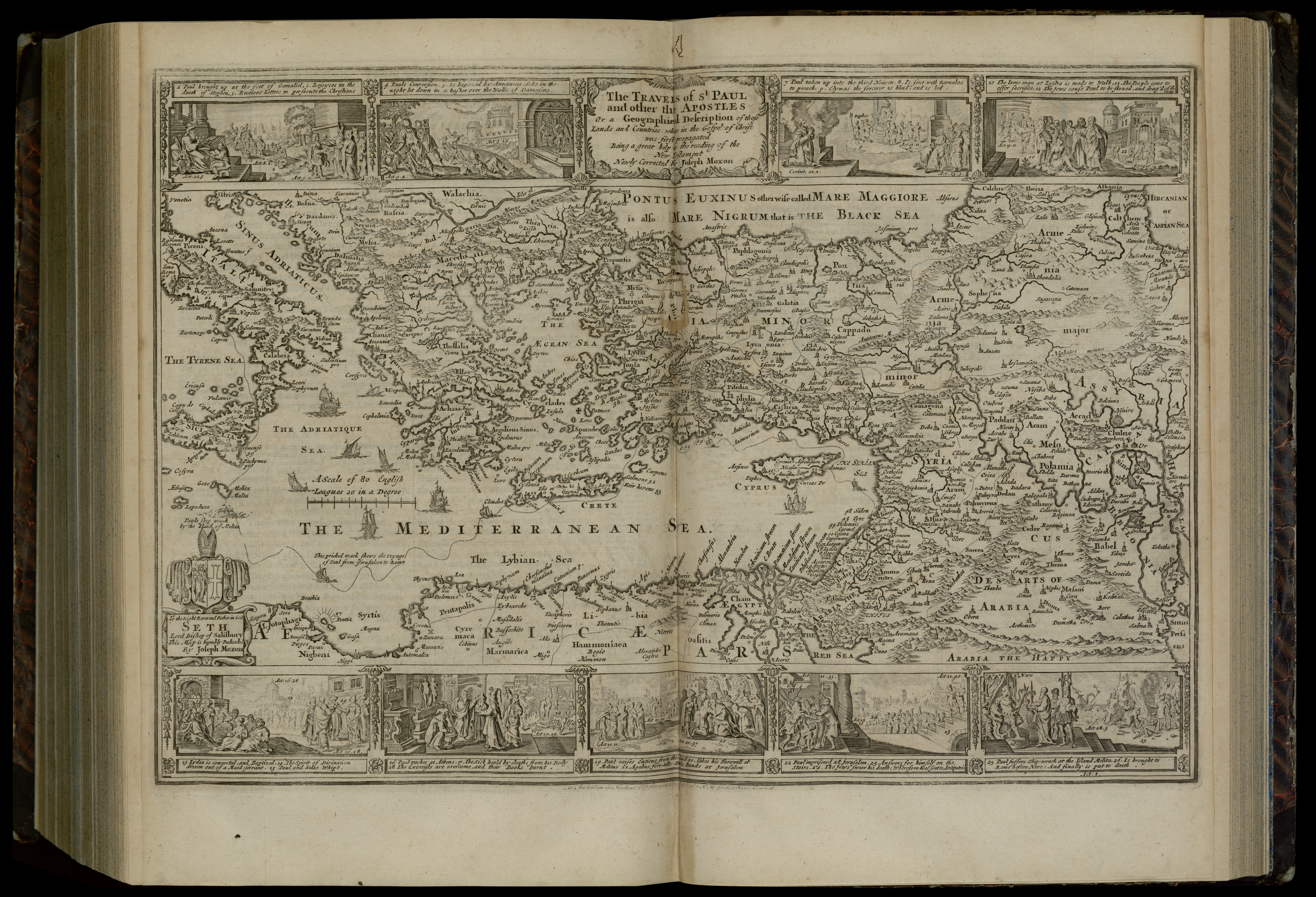
[edit]| Joseph Moxon: The travels of St. Paul and other the Apostles or a geographical description of those lands and countries where in the Gospel of Christ was first propagated
( |
||||||||||||||||||||||||
|---|---|---|---|---|---|---|---|---|---|---|---|---|---|---|---|---|---|---|---|---|---|---|---|---|
| Artist |
| |||||||||||||||||||||||
| Contributors | Visscher, Nicolaes, 1618-1679 Moxon, James | |||||||||||||||||||||||
| Title |
The travels of St. Paul and other the Apostles or a geographical description of those lands and countries where in the Gospel of Christ was first propagated |
|||||||||||||||||||||||
| Description |
The travels of St. Paul and other the Apostles or a geographical description of those lands and countries where in the Gospel of Christ was first propagated. Being a great help in the reading of the New Testament . Newly corrected by Joseph Moxon. |
|||||||||||||||||||||||
| Language | English | |||||||||||||||||||||||
| Publication date | 1715 | |||||||||||||||||||||||
| Dimensions | height: 315 mm (12.40 in); width: 460 mm (18.11 in) | |||||||||||||||||||||||
| Collection |
|
|||||||||||||||||||||||
| Current location |
|
|||||||||||||||||||||||
| Place of publication | London | |||||||||||||||||||||||
| search Merhav catalog | London | |||||||||||||||||||||||
| Notes | Copperplate; The fifth of the series of six Biblical maps by Nicolas Visscher, translated from the Dutch by Joseph Moxon. For the sixth map see Jerusalem; In: The Holy Bible, London, 1715, New Testament, before the Acts of the Apostles, p.102. S2= 82 B 1861. | |||||||||||||||||||||||
| IE PID | IE200067341 | |||||||||||||||||||||||
| Rosetta filename | FL200067343 | |||||||||||||||||||||||
| NNL item ID (P3959) | 990023688020205171 | |||||||||||||||||||||||
| search Merhav catalog | English, Joseph Moxon | |||||||||||||||||||||||
| search Merhav catalog | ChristianityMiddle EastMaps | |||||||||||||||||||||||
| Source/Photographer |
|
|||||||||||||||||||||||
| Other versions | ||||||||||||||||||||||||
| Jpg / Tif version |
|
|||||||||||||||||||||||


.jpg)

.jpg&action=edit§ion=1)
Licensing
[edit].jpg&action=edit§ion=2)
The copyright situation of this work is theoretically uncertain, because in the country of origin copyright lasts 70 years after the death of the author, and the date of the author's death is unknown. However, the date of creation of the work was over 120 years ago, and it is thus a reasonable assumption that the copyright has expired (see here for the community discussion). Do not use this template if the date of death of the author is known.
| |
| This file has been identified as being free of known restrictions under copyright law, including all related and neighboring rights. | |
File history
Click on a date/time to view the file as it appeared at that time.
| Date/Time | Thumbnail | Dimensions | User | Comment | |
|---|---|---|---|---|---|
| current | 19:26, 28 July 2023 | | 6,852 × 4,672 (51.48 MB) | Geagea (talk | contribs) | pattypan 22.03 |
You cannot overwrite this file.
File usage on Commons
The following page uses this file:
.jpg&oldid=801870382)