File:Jordan Craters.jpg

Original file (2,550 × 3,300 pixels, file size: 1.76 MB, MIME type: image/jpeg)
Captions
Captions
Summary
[edit]
| Description |
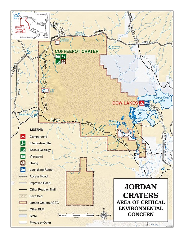
English: The name Jordan Craters lava field is applied to the Holocene basalt lava flows and their eruptive vents that lie 30 km (19 mi) northwest of the town of Jordan Valley, Oregon. The largest vent is at Coffeepot Crater, a breached crater adjacent to a remnant of its scoria cone. Other smaller spatter-cone vents are aligned to the west-southwest along a fissure extending about 0.3 km (0.2 mi). Eruptions emanating from the vents covered 68 km2 (26 mi2) with 1 km3 (0.24 mi3) with basaltic pahoehoe lava. During the eruption, the cone of Coffeepot Crater held a lava pond that occasionally broke through the confining walls to raft away of the northeastern and southeastern flanks of the cone. Lava flows spread outward, buried existing drainages, and dammed gulches to form Upper and Lower Cow Lakes on the east side of the lava field. A southeasterly lobe of tube-fed lava reached 2 km (1.2 mi) down ancestral Cow Creek before stopping.
The age of the Jordan Craters lava field is commonly cited as 3,200 yr, the age from a charred twig obtained during a lake-sediment coring experiment in 1986. The twig, from the contact between silt and mud of Upper Cow Lake and underlying stream gravels, presumably marks the time when lava dammed the basin, but the relationship with the lava hasn't been well established. The charcoal formation age may predate the deposition of lake sediment by some unknown amount. Thus the 3,200-yr age is best considered the oldest possible age for the flows. Older lava flows surround the Jordan Craters lava field; they range in age from 0.25 to 1.86 Ma and have volumes ranging from 0.8-1.0 km3 (0.2 – 0.25 mi3). Coffee Pot Crater, the only feature to which there is vehicle access, covers about two-thirds of a square mile and is a well-preserved, steep-sided crater. One of the most interesting features in the vicinity of Coffee Pot is a sequence of roughly aligned spatter cones. They consist of blocks of lava, probably ejected in a semi-molten state, that have welded together, forming cones. The interiors of the cones have a glassy furnace lining look because they were vents for hot gasses. Jordan Craters is located in the southeast corner of Oregon in Malheur County. From Highway 95, eight miles north of Jordan Valley, turn west at the Jordan Craters sign onto Cow Creek Road. Follow BLM Jordan Craters access signs 25 miles to the site. www.youtube.com/watch?v=FYbOrQxOMLc For more information contact: 100 Oregon St. Vale, OR 97918 541-473-3144 |
| Date | |
| Source | https://www.flickr.com/photos/50169152@N06/30565983376/ |
| Author | BLM Oregon & Washington |
Licensing
[edit]
- You are free:
- to share – to copy, distribute and transmit the work
- to remix – to adapt the work
- Under the following conditions:
- attribution – You must give appropriate credit, provide a link to the license, and indicate if changes were made. You may do so in any reasonable manner, but not in any way that suggests the licensor endorses you or your use.
| This image was originally posted to Flickr by BLM Oregon & Washington at https://flickr.com/photos/50169152@N06/30565983376. It was reviewed on 7 March 2022 by FlickreviewR 2 and was confirmed to be licensed under the terms of the cc-by-2.0. |
File history
Click on a date/time to view the file as it appeared at that time.
| Date/Time | Thumbnail | Dimensions | User | Comment | |
|---|---|---|---|---|---|
| current | 20:39, 7 March 2022 | | 2,550 × 3,300 (1.76 MB) | Ser Amantio di Nicolao (talk | contribs) | Uploaded a work by BLM Oregon & Washington from https://www.flickr.com/photos/50169152@N06/30565983376/ with UploadWizard |
You cannot overwrite this file.
File usage on Commons
There are no pages that use this file.