File:John Gill Farmstead.jpg
Jump to navigation
Jump to search

Size of this preview: 800 × 450 pixels. Other resolutions: 320 × 180 pixels | 640 × 360 pixels | 1,024 × 576 pixels | 1,280 × 720 pixels | 2,816 × 1,584 pixels.
Original file (2,816 × 1,584 pixels, file size: 1.32 MB, MIME type: image/jpeg)
Captions
Captions
Add a one-line explanation of what this file represents
|
This is an image of a place or building that is listed on the National Register of Historic Places in the United States of America. Its reference number is 97000373. |
| Camera location | | View this and other nearby images on: OpenStreetMap |
|---|
| Description |
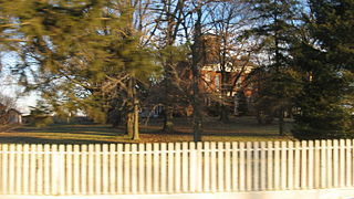
English: House at the John Gill Farmstead, located at 12310 Lancaster-Newark Road (State Route 37 west of Millersport in Walnut Township, Fairfield County, Ohio, United States. The complex is listed on the National Register of Historic Places. |
||
| Date | Taken on 27 December 2013 | ||
| Source | Own work | ||
| Author | Nyttend | ||
| Permission (Reusing this file) |
|
File history
Click on a date/time to view the file as it appeared at that time.
| Date/Time | Thumbnail | Dimensions | User | Comment | |
|---|---|---|---|---|---|
| current | 15:15, 31 December 2013 | | 2,816 × 1,584 (1.32 MB) | Nyttend (talk | contribs) | {{Location|39|54|15|N|82|33|35|W}} {{Information |Description={{en|House at the {{w|John Gill Farmstead}}, located at 12310 Lancaster-Newark Road ({{w|Ohio State Route 37|State Route 37}} west of {{w|Millersport, Ohio|Millersport}} in {{w|Walnut Townsh... |
You cannot overwrite this file.
File usage on Commons
The following 2 pages use this file:
File usage on other wikis
The following other wikis use this file:
- Usage on en.wikipedia.org
- Usage on es.wikipedia.org
- Usage on eu.wikipedia.org
- Usage on fa.wikipedia.org
- Usage on pt.wikipedia.org
- Usage on vi.wikipedia.org
- Usage on www.wikidata.org
- Usage on zh.wikipedia.org