File:Joggins Cliffs, Nova Scotia.jpg
Jump to navigation
Jump to search

Size of this preview: 600 × 600 pixels. Other resolutions: 240 × 240 pixels | 480 × 480 pixels | 768 × 768 pixels | 1,024 × 1,024 pixels | 2,048 × 2,048 pixels | 3,000 × 3,000 pixels.
Original file (3,000 × 3,000 pixels, file size: 4.64 MB, MIME type: image/jpeg)
Captions
Captions
Add a one-line explanation of what this file represents
Summary
[edit]
| Description |
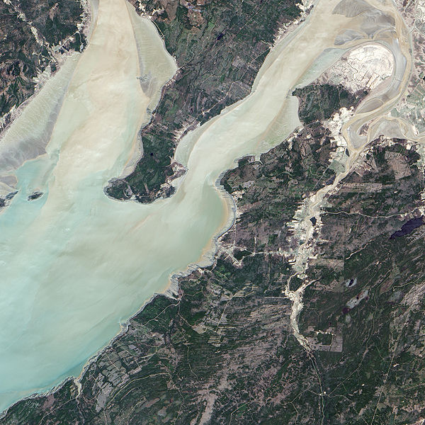
English: The Advanced Land Imager (ALI) on NASA’s Earth Observing-1 satellite captured this true-color image of the Joggins Fossil Cliffs region. The fossil cliffs trace a curving line through the middle of this image, with Cumberland Basin in the west and a small village in the east. Sunlight and sediment color the water of Cumberland Basin pastel. On land, colors vary from deep green vegetation to brown bare rock to gray paved surfaces. Roads cut crooked lines through the landscape. The cliffs appear gray-beige, giving way to buff color nearest the water. |
| Date | |
| Source | NASA Earth Observatory |
| Author | Jesse Allen |
Instrument: EO-1 - ALI
Licensing
[edit]
| This file is in the public domain in the United States because it was solely created by NASA. NASA copyright policy states that "NASA material is not protected by copyright unless noted". (See Template:PD-USGov, NASA copyright policy page or JPL Image Use Policy.) | ||
 |
Warnings:
|
| Annotations | This image is annotated: View the annotations at Commons |
File history
Click on a date/time to view the file as it appeared at that time.
| Date/Time | Thumbnail | Dimensions | User | Comment | |
|---|---|---|---|---|---|
| current | 13:53, 23 May 2009 | | 3,000 × 3,000 (4.64 MB) | Originalwana (talk | contribs) | {{Information |Description={{en|1=The Advanced Land Imager (ALI) on NASA’s Earth Observing-1 satellite captured this true-color image of the Joggins Fossil Cliffs region. The fossil cliffs trace a curving line through the middle of this image, with Cumb |
You cannot overwrite this file.
File usage on Commons
There are no pages that use this file.
File usage on other wikis
The following other wikis use this file:
- Usage on de.wikipedia.org
- Usage on en.wikipedia.org
- Usage on fr.wikipedia.org
- Usage on hr.wikipedia.org
- Usage on ru.wikipedia.org
- Usage on sh.wikipedia.org
- Usage on uk.wikipedia.org