File:Jinju.svg
Jump to navigation
Jump to search

Size of this PNG preview of this SVG file: 728 × 582 pixels. Other resolutions: 300 × 240 pixels | 601 × 480 pixels | 961 × 768 pixels | 1,280 × 1,023 pixels | 2,560 × 2,047 pixels.
Original file (SVG file, nominally 728 × 582 pixels, file size: 365 KB)
Captions
Captions
Add a one-line explanation of what this file represents
Summary
[edit]
| Description |
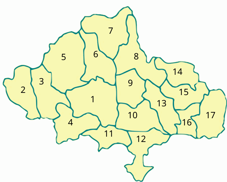
English: Full Jinju City Map including outer city
한국어: 진주시 전체 지도 |
| Date | |
| Source | Own work |
| Author | Asfreeas |
| Permission (Reusing this file) |
public domain |
- 1 = 진주 시
- 2 = 수곡 면
- 3 = 대평 면
- 4 = 내동 면
- 5 = 명석 면
- 6 = 집현 면
- 7 = 미천 면
- 8 = 대곡 면
- 9 = 금산 면
- 10 = 문산 읍
- 11 = 내곡 면
- 12 = 정촌 면
- 13 = 금곡 면
- 14 = 지수 면
- 15 = 사봉 면
- 16 = 일반성 면
- 17 = 이반성 면
Licensing
[edit]
| I, the copyright holder of this work, release this work into the public domain. This applies worldwide. In some countries this may not be legally possible; if so: I grant anyone the right to use this work for any purpose, without any conditions, unless such conditions are required by law. |
File history
Click on a date/time to view the file as it appeared at that time.
| Date/Time | Thumbnail | Dimensions | User | Comment | |
|---|---|---|---|---|---|
| current | 10:00, 1 July 2011 | | 728 × 582 (365 KB) | Asfreeas (talk | contribs) | {{Information |Description ={{en|1=Full Jinju City Map including outer city}} {{ko|1=진주시 전체 지도}} |Source ={{own}} |Author =Asfreeas |Date =2011-7-1 |Permission = |other_versions = }} [[Cate |
You cannot overwrite this file.
File usage on Commons
There are no pages that use this file.