File:Jerusalem light rail map in Arabic.png
Jump to navigation
Jump to search

Size of this preview: 766 × 600 pixels. Other resolutions: 307 × 240 pixels | 613 × 480 pixels | 981 × 768 pixels | 1,280 × 1,002 pixels | 2,560 × 2,005 pixels | 3,204 × 2,509 pixels.
Original file (3,204 × 2,509 pixels, file size: 332 KB, MIME type: image/png)
Captions
Captions
Add a one-line explanation of what this file represents
Summary
[edit]
| Description |
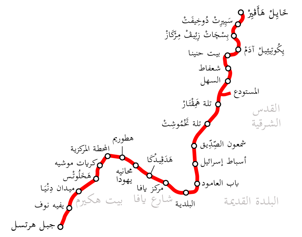
English: Jerusalem light rail map in Arabic
العربية: خريطة القطار الخفيف في القدس |
| Date | |
| Source | Derivative from this file |
| Author |
|
Licensing
[edit]
I, the copyright holder of this work, hereby publish it under the following license:
This file is licensed under the Creative Commons Attribution-Share Alike 3.0 Unported license.
- You are free:
- to share – to copy, distribute and transmit the work
- to remix – to adapt the work
- Under the following conditions:
- attribution – You must give appropriate credit, provide a link to the license, and indicate if changes were made. You may do so in any reasonable manner, but not in any way that suggests the licensor endorses you or your use.
- share alike – If you remix, transform, or build upon the material, you must distribute your contributions under the same or compatible license as the original.
File history
Click on a date/time to view the file as it appeared at that time.
| Date/Time | Thumbnail | Dimensions | User | Comment | |
|---|---|---|---|---|---|
| current | 12:46, 13 April 2024 | | 3,204 × 2,509 (332 KB) | Moataz1997 (talk | contribs) | Edit station name |
| 11:19, 12 March 2021 |  | 3,204 × 2,509 (331 KB) | Moataz1997 (talk | contribs) | Add the name of the Beit HaKeerem neighborhood | |
| 21:12, 19 January 2021 |  | 3,204 × 2,509 (321 KB) | Moataz1997 (talk | contribs) | Uploaded own work with UploadWizard |
You cannot overwrite this file.
File usage on Commons
The following 6 pages use this file:
- User:Chumwa/OgreBot/Public transport information/2021 January 11-20
- User:Chumwa/OgreBot/Public transport information/2021 March 11-20
- User:Chumwa/OgreBot/Public transport information/2024 April 11-20
- User:Chumwa/OgreBot/Transport Maps/2021 January 11-20
- User:Chumwa/OgreBot/Transport Maps/2021 March 11-20
- User:Chumwa/OgreBot/Transport Maps/2024 April 11-20
File usage on other wikis
The following other wikis use this file:
- Usage on ar.wikipedia.org