File:Jean Delagrive, Nouvelle Carte de la Terre Sainte 01-north (FL13736241 2368514).jpg
Jump to navigation
Jump to search

Size of this preview: 800 × 588 pixels. Other resolutions: 320 × 235 pixels | 640 × 471 pixels | 1,024 × 753 pixels | 1,280 × 941 pixels | 2,560 × 1,882 pixels | 7,496 × 5,512 pixels.
Original file (7,496 × 5,512 pixels, file size: 67.12 MB, MIME type: image/jpeg)
Captions
Captions
Add a one-line explanation of what this file represents
Summary
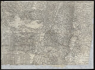
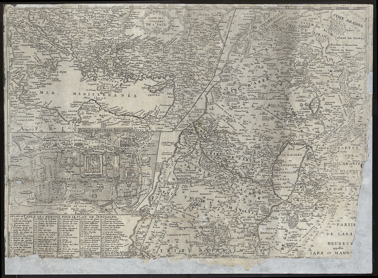
[edit]| Jean Delagrive: Nouvelle Carte de la Terre Sainte
( |
||||||||||||||||||||||||
|---|---|---|---|---|---|---|---|---|---|---|---|---|---|---|---|---|---|---|---|---|---|---|---|---|
| Artist |
| |||||||||||||||||||||||
| Contributors | Mondhare, L. | |||||||||||||||||||||||
| Title |
Nouvelle Carte de la Terre Sainte |
|||||||||||||||||||||||
| Publisher |
Chez Mondhare |
|||||||||||||||||||||||
| Description |
Nouvelle Carte de la Terre Sainte. Dedie a Monseigneur Le Duc Daumont...Par M.L'Abbe de la Grive. |
|||||||||||||||||||||||
| Language | French | |||||||||||||||||||||||
| Publication date | 1772 | |||||||||||||||||||||||
| Medium | 2 sheets ; | |||||||||||||||||||||||
| Dimensions | height: 431 mm (16.96 in); width: 608 mm (23.93 in) each. | |||||||||||||||||||||||
| Collection |
|
|||||||||||||||||||||||
| Current location |
|
|||||||||||||||||||||||
| Place of publication | Paris | |||||||||||||||||||||||
| search Merhav catalog | Paris | |||||||||||||||||||||||
| Notes | Copperplate; 3 insets: Plan de l'ancienne Jerusalem ; Carte des voiages de St. Paul (north sheet). Campement des Israelites dans le desert a la sortie de l'Egypte... (south sheet).; At bottom: vessels of the Temple. Temple vessels. On left: Adam and Eve Expulsion from the Garden of Eden.; Cartouch shows Moses and Aaron, Bronze serpent. | |||||||||||||||||||||||
| IE PID | IE13736239 | |||||||||||||||||||||||
| Rosetta filename | FL13736241 | |||||||||||||||||||||||
| NNL item ID (P3959) | 990023685140205171 | |||||||||||||||||||||||
| search Merhav catalog | French, Jean Delagrive | |||||||||||||||||||||||
| search Merhav catalog | Twelve tribes of IsraelMapsChez Mondhare | |||||||||||||||||||||||
| Source/Photographer |
|
|||||||||||||||||||||||
| Other versions | ||||||||||||||||||||||||
| Jpg / Tif version |
|
|||||||||||||||||||||||
,_g%C3%A9ographe_et_graveur._-_P2672_-_Mus%C3%A9e_Carnavalet.jpg)

.jpg)

.jpg&action=edit§ion=1)
Licensing
[edit].jpg&action=edit§ion=2)
The copyright situation of this work is theoretically uncertain, because in the country of origin copyright lasts 70 years after the death of the author, and the date of the author's death is unknown. However, the date of creation of the work was over 120 years ago, and it is thus a reasonable assumption that the copyright has expired (see here for the community discussion). Do not use this template if the date of death of the author is known.
| |
| This file has been identified as being free of known restrictions under copyright law, including all related and neighboring rights. | |
File history
Click on a date/time to view the file as it appeared at that time.
| Date/Time | Thumbnail | Dimensions | User | Comment | |
|---|---|---|---|---|---|
| current | 11:29, 28 July 2023 | | 7,496 × 5,512 (67.12 MB) | Geagea (talk | contribs) | pattypan 22.03 |
You cannot overwrite this file.
File usage on Commons
The following page uses this file:
.jpg&oldid=787583113)