File:Jean Boisseau, Description de la ville de Ierusalem auec les noms des Saints lieux ou antiquitez qui sont visitez par les pellerins et voiageurs (FL169318439 2367965).jpg
Jump to navigation
Jump to search

Size of this preview: 791 × 600 pixels. Other resolutions: 317 × 240 pixels | 633 × 480 pixels | 1,013 × 768 pixels | 1,280 × 971 pixels | 2,560 × 1,942 pixels | 5,770 × 4,376 pixels.
Original file (5,770 × 4,376 pixels, file size: 23.14 MB, MIME type: image/jpeg)
Captions
Captions
Add a one-line explanation of what this file represents
Summary
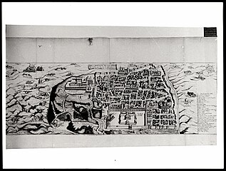
[edit]| Jean Boisseau: Description de la ville de Ierusalem auec les noms des Saints lieux ou antiquitez qui sont visitez par les pellerins et voiageurs
( |
||||||||||||||||||||||||
|---|---|---|---|---|---|---|---|---|---|---|---|---|---|---|---|---|---|---|---|---|---|---|---|---|
| Artist |
| |||||||||||||||||||||||
| Contributors | Amico, Bernardino | |||||||||||||||||||||||
| Title |
Description de la ville de Ierusalem auec les noms des Saints lieux ou antiquitez qui sont visitez par les pellerins et voiageurs |
|||||||||||||||||||||||
| Publisher |
chez Iean Boisseau |
|||||||||||||||||||||||
| Description |
Description de la ville de Ierusalem auec les noms des Saints lieux ou antiquitez qui sont visitez par les pellerins et voiageurs. |
|||||||||||||||||||||||
| Language | French | |||||||||||||||||||||||
| Publication date | 1643 | |||||||||||||||||||||||
| Dimensions | 247 × 470 mm (9.72 × 18.50 in) | |||||||||||||||||||||||
| Collection |
|
|||||||||||||||||||||||
| Current location |
|
|||||||||||||||||||||||
| Place of publication | Paris | |||||||||||||||||||||||
| search Merhav catalog | Paris | |||||||||||||||||||||||
| Notes | Copperplate; Plan; Drawn after Bernardino Amico; Photocopy of the original map.; צילום המפה מאוסף קפלן, אונ' תל אביב. | |||||||||||||||||||||||
| IE PID | IE169318437 | |||||||||||||||||||||||
| Rosetta filename | FL169318439 | |||||||||||||||||||||||
| NNL item ID (P3959) | 990023679650205171 | |||||||||||||||||||||||
| search Merhav catalog | French, Jean Boisseau | |||||||||||||||||||||||
| search Merhav catalog | chez Iean Boisseau | |||||||||||||||||||||||
| Source/Photographer |
|
|||||||||||||||||||||||
| Other versions | ||||||||||||||||||||||||
| Jpg / Tif version |
|
|||||||||||||||||||||||

.jpg)

.jpg&action=edit§ion=1)
Licensing
[edit].jpg&action=edit§ion=2)
The copyright situation of this work is theoretically uncertain, because in the country of origin copyright lasts 70 years after the death of the author, and the date of the author's death is unknown. However, the date of creation of the work was over 120 years ago, and it is thus a reasonable assumption that the copyright has expired (see here for the community discussion). Do not use this template if the date of death of the author is known.
| |
| This file has been identified as being free of known restrictions under copyright law, including all related and neighboring rights. | |
File history
Click on a date/time to view the file as it appeared at that time.
| Date/Time | Thumbnail | Dimensions | User | Comment | |
|---|---|---|---|---|---|
| current | 10:55, 26 July 2023 | | 5,770 × 4,376 (23.14 MB) | Geagea (talk | contribs) | pattypan 22.03 |
You cannot overwrite this file.
File usage on Commons
The following page uses this file:
.jpg&oldid=786950306)