File:Japan Korea provisional zone E.svg
Jump to navigation
Jump to search

Size of this PNG preview of this SVG file: 386 × 322 pixels. Other resolutions: 288 × 240 pixels | 576 × 480 pixels | 921 × 768 pixels | 1,228 × 1,024 pixels | 2,455 × 2,048 pixels.
Original file (SVG file, nominally 386 × 322 pixels, file size: 168 KB)
Captions
Captions
Add a one-line explanation of what this file represents
Summary
[edit]
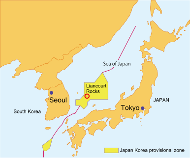
| Description | Provisional zone between Japan and South Korea in the Sea of Japan, based on "Japan-South Korea Fisheries Agreement" in 1998. Self-made SVG file. |
| Date | |
| Source | Own work |
| Author | Eurodollers |
| SVG development | This map was created with Adobe Illustrator. |
Licensing
[edit]
I, the copyright holder of this work, hereby publish it under the following licenses:

|
Permission is granted to copy, distribute and/or modify this document under the terms of the GNU Free Documentation License, Version 1.2 or any later version published by the Free Software Foundation; with no Invariant Sections, no Front-Cover Texts, and no Back-Cover Texts. A copy of the license is included in the section entitled GNU Free Documentation License. |
| This file is licensed under the Creative Commons Attribution-Share Alike 3.0 Unported license. | ||
| ||
| This licensing tag was added to this file as part of the GFDL licensing update. |
You may select the license of your choice.
File history
Click on a date/time to view the file as it appeared at that time.
| Date/Time | Thumbnail | Dimensions | User | Comment | |
|---|---|---|---|---|---|
| current | 14:41, 16 July 2008 | | 386 × 322 (168 KB) | Ponta2 (talk | contribs) | Reverted to version as of 09:53, 16 April 2008 |
| 03:03, 16 July 2008 |  | 386 × 322 (210 KB) | 쿠도군 (talk | contribs) | wrong. | |
| 03:02, 16 July 2008 |  | 386 × 322 (210 KB) | 쿠도군 (talk | contribs) | ||
| 02:59, 16 July 2008 |  | 386 × 322 (192 KB) | 쿠도군 (talk | contribs) | ||
| 09:53, 16 April 2008 |  | 386 × 322 (168 KB) | Eurodollers (talk | contribs) | {{Information |Description= Provisional zone between Japan and South Korea in the Sea of Japan, based on "Japan-South Korea Fisheries Agreement" in 1998. Self-made SVG file. |Source=self-made |Date= April 16, 2008 |Author= [[User:Eurodollers|Eurodollers |
You cannot overwrite this file.
File usage on Commons
There are no pages that use this file.
File usage on other wikis
The following other wikis use this file:
- Usage on nl.wikipedia.org
- Usage on no.wikipedia.org
- Usage on uk.wikipedia.org