File:Janowiec Wielki (gmina) map.png

Original file (671 × 944 pixels, file size: 170 KB, MIME type: image/png)
Captions
Captions
Summary
[edit]_map.png&action=edit§ion=1)
| Description |
English: Location map |
| Date | |
| Source | Own work |
| Author | Smat |
| Description |
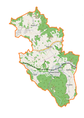
Polski: Mapa gminy Janowice Wielkie, Polska
English: Map of Janowice Wielkie (gmina), Poland |
|||||||||
| Date | ||||||||||
| Source | You may find a page on the OpenStreetMap wiki page for Janowice Wielkie (gmina) | |||||||||
| Creator |
OpenStreetMap contributors OpenStreetMap contributors |
|||||||||
| Permission (Reusing this file) |
OpenStreetMap data is available under the Open Database License (details). Map tiles are licensed under the Creative Commons Attribution-ShareAlike 2.0 license (CC-BY-SA 2.0).
This file is licensed under the Creative Commons Attribution-Share Alike 2.0 Generic license.
|
|||||||||
| Geotemporal data | ||||||||||
| Bounding box |
|
|||||||||
| Georeferencing | If inappropriate please set warp_status = skip to hide. | |||||||||
Licensing
[edit]_map.png&action=edit§ion=2)
| This work contains information from OpenStreetMap, which is made available under the Open Database License (ODbL).
The ODbL does not require any particular license for maps produced from ODbL data. Prior to 1 August 2020, map tiles produced by the OpenStreetMap Foundation were licensed under the CC-BY-SA-2.0 license. Maps produced by other people may be subject to other licences. |
File history
Click on a date/time to view the file as it appeared at that time.
| Date/Time | Thumbnail | Dimensions | User | Comment | |
|---|---|---|---|---|---|
| current | 11:19, 5 January 2017 | | 671 × 944 (170 KB) | Smat (talk | contribs) | User created page with UploadWizard |
You cannot overwrite this file.
File usage on Commons
There are no pages that use this file.
File usage on other wikis
The following other wikis use this file:
- Usage on de.wikipedia.org
- Usage on pl.wikipedia.org
- Trzcińsko
- Janowice Wielkie
- Janowice Wielkie (gmina)
- Komarno (województwo dolnośląskie)
- Miedzianka (województwo dolnośląskie)
- Mniszków (województwo dolnośląskie)
- Radomierz (województwo dolnośląskie)
- Pałac w Janowicach Wielkich
- Dwór w Mniszkowie
- Dwór w Radomierzu
- Zamek Bolczów
- Hutniczy Potok (dopływ Bobru)
- Krupówka (potok)
- Parafia Chrystusa Króla w Janowicach Wielkich
- Janowice Wielkie (stacja kolejowa)
- Dopływ spod Mniszkowa
- Trzcińsko (przystanek kolejowy)
- Trzcińskie Mokradła
- Pałac w Komarnie
- Parafia Matki Bożej Różańcowej w Radomierzu
- Moduł:Mapa/dane/Janowice Wielkie (gmina)
- Kościół św. Jana Chrzciciela w Miedziance
- Kościół Chrystusa Króla w Janowicach Wielkich
- Kościół Wniebowzięcia Najświętszej Maryi Panny w Janowicach Wielkich
- Chałupy (Komarno)
- Kościół św. Jana Chrzciciela w Komarnie
- Usage on pl.wikibooks.org
_map.png&oldid=728505530)