File:Jangmi 2008-09-27 0445Z.jpg
Jump to navigation
Jump to search

Size of this preview: 473 × 599 pixels. Other resolutions: 189 × 240 pixels | 379 × 480 pixels | 606 × 768 pixels | 808 × 1,024 pixels | 1,617 × 2,048 pixels | 6,000 × 7,600 pixels.
Original file (6,000 × 7,600 pixels, file size: 4.93 MB, MIME type: image/jpeg)
Captions
Captions
Add a one-line explanation of what this file represents
Summary
[edit]
| Description |
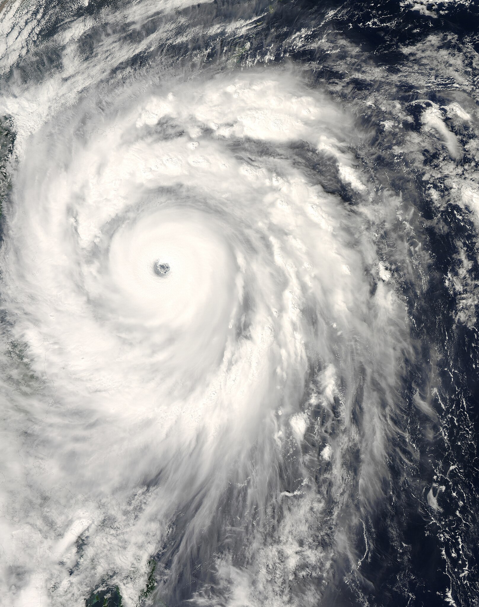
English: The title of “strongest storm of 2008” goes to Typhoon Jangmi, shown in this image from the Moderate Resolution Imaging Spectroradiometer (MODIS) on NASA’s Aqua satellite from September 27, 2008.
Seen from space, even a super typhoon seems more beautiful than dangerous. The 50-kilometer-wide eye of Jangmi is encircled by a smooth disk of clouds. Bands of clouds swirl gracefully into the low-pressure heart of the storm. The smooth cloud band north of the eye is studded with thunderstorms. On the ground, Jangmi was less lovely It was not only the strongest storm in any ocean basin in 2008 but the only storm to reach category 5 strength anywhere in the world that year. |
| Date | |
| Source | http://rapidfire.sci.gsfc.nasa.gov/cgi-bin/imagery/single.cgi?image=Jangmi.A2008271.0445.250m.jpg |
| Author | MODIS image captured by NASA’s Aqua satellite |
| Camera location | | View this and other nearby images on: OpenStreetMap |
|---|
Licensing
[edit]
| This file is in the public domain in the United States because it was solely created by NASA. NASA copyright policy states that "NASA material is not protected by copyright unless noted". (See Template:PD-USGov, NASA copyright policy page or JPL Image Use Policy.) | ||
 |
Warnings:
|
File history
Click on a date/time to view the file as it appeared at that time.
| Date/Time | Thumbnail | Dimensions | User | Comment | |
|---|---|---|---|---|---|
| current | 13:58, 30 May 2018 | | 6,000 × 7,600 (4.93 MB) | Nino Marakot (talk | contribs) | Reverted to version as of 05:09, 9 January 2018 (UTC) |
| 23:03, 21 April 2018 |  | 1,723 × 2,089 (1.06 MB) | Saxitoxin (talk | contribs) | Less gray | |
| 23:02, 21 April 2018 |  | 1,723 × 2,089 (2.64 MB) | Saxitoxin (talk | contribs) | More storm centered | |
| 05:09, 9 January 2018 |  | 6,000 × 7,600 (4.93 MB) | Nino Marakot (talk | contribs) | Reverted to version as of 22:20, 2 November 2008 (UTC) - It's gallery version. Please separate them (it would become 3rd party if stayed) | |
| 15:48, 24 November 2017 |  | 5,985 × 7,980 (9.62 MB) | Meow (talk | contribs) | Rebuilt. | |
| 22:20, 2 November 2008 |  | 6,000 × 7,600 (4.93 MB) | Cyclonebiskit (talk | contribs) | {{Information |Description={{en|1={{en|1=Satellite image of Typhoon Jangmi at 0445 UTC Sept. 27, 2008.}}This photo-like image was taken by the Aqua MODIS Satellite as Typhoon Jangmi (or Super Typhoon 19W according to the JTWC) moved closer to the island o |
You cannot overwrite this file.
File usage on Commons
The following 5 pages use this file:
File usage on other wikis
The following other wikis use this file:
- Usage on de.wikipedia.org
- Usage on en.wikipedia.org
- Usage on ja.wikipedia.org
- Usage on ko.wikipedia.org
- Usage on pt.wikipedia.org
- Usage on vi.wikipedia.org
- Usage on zh-yue.wikipedia.org
- Usage on zh.wikipedia.org